Downpatrick is a town in County Down, Northern Ireland. It is on the Lecale peninsula, about 21 mi (34 km) south of Belfast. In the Middle Ages, it was the capital of the Dál Fiatach, the main ruling dynasty of Ulaid. Its cathedral is said to be the burial place of Saint Patrick. Today, it is the county town of Down and the joint headquarters of Newry, Mourne and Down District Council. Downpatrick had a population of 11,545 according to the 2021 Census.
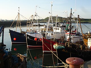
Ardglass is a coastal fishing village, townland and civil parish in County Down, Northern Ireland, in the historic barony of Lecale Lower. It is still a relatively important fishing harbour. It is situated on the B1 Ardglass to Downpatrick road, about 6 miles to the south east of Downpatrick, in the Lecale peninsula on the Irish Sea. It had a population of 1,668 in the 2001 Census, and is located within the Newry, Mourne and Down area.

Down Cathedral, the Cathedral Church of the Holy and Undivided Trinity, is a Church of Ireland cathedral located in the town of Downpatrick in Northern Ireland. It stands on Cathedral Hill overlooking the town. It is one of two cathedrals in the Diocese of Down and Dromore. The cathedral is the centre point of Downpatrick, a relatively new name for the settlement, having only come into usage in the seventeenth century.

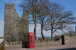
Ardtole Church is a 15th-century ruined church standing on a hilltop overlooking the Irish Sea and the Isle of Man, 0.75 miles (1.2 km) north-east of the town of Ardglass in County Down, Northern Ireland, at grid ref: J564382. It was formerly the parish church of Ardglass and is dedicated to St Nicholas, the patron saint of sailors.

The Giant's Ring is a henge monument at Ballynahatty, near Shaw's Bridge, Belfast, Northern Ireland. It was originally preserved by Viscount Dungannon. The inscribed stone tablet on the wall surrounding the site which details Viscount Dungannon's interest was carved by Belfast stonecarver Charles A Thompson about c.1919.

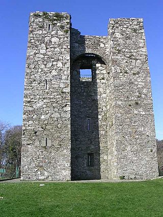
Kilclief Castle is a tower-house castle beside Strangford Lough and 2.5 miles (4 km) south of the village of Strangford, County Down, Northern Ireland. Kilclief is a hamlet on the Strangford to Ardglass road.
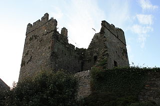
Audley's Castle is a 15th-century castle located 1 mile (1.6 km) north-east of Strangford, County Down, Northern Ireland, on a rocky height overlooking Strangford Lough. It is a three-storey Tower house named after its 16th century owner, John Audley. Audley's Castle tower house and bawn is a State Care Historic Monument in the townland of Castleward, in Down District Council area, at grid ref: J5781 5058.

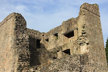
Greencastle is a castle in County Down, Northern Ireland. While it dates mainly from the 13th century, it had substantial 15th- and 16th-century alterations. It was originally surrounded by outer rectangular walls with four corner towers. It is likely to have been built by Hugh de Lacy, along with Carlingford Castle on the opposite side of Carlingford Lough, to guard the narrow entry channel to the Lough, and the ferry crossing between the two.

Grey Abbey is a ruined Cistercian priory in Greyabbey, County Down, Northern Ireland. Currently maintained by the Northern Ireland Environment Agency, it is a monument in state care in the townland of Rosemount, on the eastern edge of the village of Greyabbey in the Ards and North Down local government district.

Struell Wells are a set of four holy wells in the townland of Struell, 1.5 miles (2.4 km) east of Downpatrick, County Down, Northern Ireland. The wells date from before the time of Saint Patrick, and even today are used for people seeking cures. On Mid-Summer Eve and the Friday before Lammas, hundreds of pilgrims used to visit Struell. The earliest written reference to the wells is in 1306, but none of the surviving buildings is earlier than about 1600. Pilgrimages to the site are well documented from the 16th century to the 19th century. The site is managed by the Northern Ireland Environment Agency.
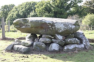
Annadorn Dolmen is a dolmen sited at the Buck's Head near Loughinisland, in the townland of Annadorn. Nearby you can find the old Annadorn school and post office in County Down, Northern Ireland. It is on the north-east shore of Loughinisland Lake, on a hillock overlooking Loughinisland Churches, a group of three ruined churches. The site is a State Care Historic Monument at grid ref: J4289 4591. Co-ordinates: Latitude: 54° 20' 29.97" N Longitude: 5° 48' 8.72" W
The White House is a ruined 17th century dwelling house at Ballyspurge, near Cloghy, County Down, Northern Ireland on the Ards Peninsula. It is situated about one mile (1.2 km) south-east of Cloghy, overlooking Slanes Bay. It is a State Care Historic Monument at grid ref: J6248 5506.

Tievenadarragh is a townland of area 1,269 acres (514 ha) in County Down, Northern Ireland. It is situated in the civil parish of Loughinisland and the historic barony of Kinelarty.

The Quoile Bridge is a railway bridge across the River Quoile in Downpatrick, County Down, Northern Ireland. It is 43 metres (141 ft) long and carries a single-track line.