| Regional route R516 | ||||
|---|---|---|---|---|
| Route information | ||||
| Length | 169 km (105 mi) | |||
| Major junctions | ||||
| West end | ||||
| East end | ||||
| Location | ||||
| Country | South Africa | |||
| Major cities | Bela-Bela | |||
| Highway system | ||||
| ||||
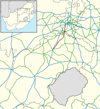
The R516 is a Regional Route in South Africa. [1]
Taking its western origin from the R511 near Thabazimbi. The road runs east to Bela-Bela (Warmbaths), where it meets, and is briefly cosigned with, the R101. It crosses the N1, before the R576 coming from the east-south-east, meets it at a t-junction. The R516 continues east, but then starts to turn north-east, crossing the R33 and then ending its journey at the R519 between Mookgophong (Naboomspruit) and Roedtan. [1]

Limpopo is the northernmost province of South Africa. It is named after the Limpopo River, which forms the province's western and northern borders. The capital and largest city in the province is Polokwane, while the provincial legislature is situated in Lebowakgomo.

The N1 is a national route in South Africa that runs from Cape Town through Bloemfontein, Johannesburg, Pretoria and Polokwane to Beit Bridge on the border with Zimbabwe. It forms the first section of the famed Cape to Cairo Road.

The R25 is a provincial route in South Africa that connects Johannesburg with Groblersdal via Kempton Park, Bapsfontein and Bronkhorstspruit.

The R59 is a provincial route in South Africa that connects Hertzogville with Alberton via Bothaville, Parys and Vereeniging. The R59 is a freeway from the R57 Junction in Sasolburg until the N12 Reading Interchange in Alberton, signposted as the Sybrand van Niekerk Freeway.

The R63 is a tarred provincial route in South Africa that connects Calvinia with Komga via Carnarvon, Victoria West, Graaff-Reinet, Somerset East and King William's Town. It is cosigned with the N10 between Eastpoort and Cookhouse for 24 kilometres.

The R82 is a provincial route in South Africa that connects Johannesburg with Kroonstad via Vereeniging and Sasolburg. It starts just south of the M1 Johannesburg Municipal Highway's interchange with the N12 Southern Bypass, going south, meeting the R59, R54, R42 & R28 routes at Vereeniging before crossing the Vaal River into the Free State & proceeding to Kroonstad. It is an alternative, but longer route to the N1 national route between Johannesburg & Kroonstad.
The R304 is a Regional Route in South Africa that connects Stellenbosch with Atlantis.
The R307 is a Regional Route in South Africa that connects the R27 north of Melkbosstrand with the R45 south-west of Moorreesburg.
The R317 is a Regional Route in South Africa that connects Bredasdorp in the south with Robertson in the north via Bonnievale.

The R353 is a Regional Route in South Africa that connects Leeu-Gamka with Brandvlei via Fraserburg and Williston.
The R354 is a Regional Route in South Africa that connects Matjiesfontein with Calvinia via Sutherland.
The R358 is a Regional Route in South Africa that connects the N7 north of Bitterfontein with the Namibian border at Onseepkans via Pofadder.
The R363 is a Regional Route in South Africa that connects Nuwerus on the N7 and Klawer, also on the N7, via Vredendal.
The R399 is a Regional Route in South Africa that connects Vredenburg with the N7 between Piketberg and De Hoek.

The N10 is a national route in South Africa connecting Gqeberha on the Eastern Cape coast with the Namibian border at Nakop, via Cradock, De Aar and Upington.
The R101 is a Regional Route in South Africa that is the designation for some of the old sections of roads that were previously the N1, prior to upgrading. It only has 2 sections, from Bellville to Worcester and from Johannesburg to Polokwane.

The R511 is a Regional Route in South Africa that connects Sandton with Thabazimbi via Hartbeespoort and Brits.
The R519 is a Regional Route in South Africa.
The R564 is a Regional Route in the City of Johannesburg Metropolitan Municipality in Gauteng, South Africa. It connects Roodepoort with Buccleuch via Northriding and Fourways.
The R576 is a Regional Route in South Africa.