The Bay Adelaide Centre is an office complex in the Financial District of Toronto, Ontario, Canada. The first phase, a 51-storey skyscraper known as Bay Adelaide West, was completed in July 2009. The second phase, the 44-storey Bay Adelaide East, was completed in October 2016. A third tower, Bay Adelaide North, is planned.
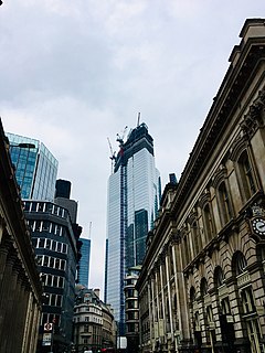
22 Bishopsgate is a commercial skyscraper under construction in London, United Kingdom. It will occupy a prominent site on Bishopsgate, in the City of London financial district, and is set to stand 278 m (912 ft) tall with 62 storeys. The project replaces an earlier plan for a 288 m (945 ft) tower named The Pinnacle, on which construction was started in 2008 but suspended in 2012 following the Great Recession, with only the concrete core of the first seven storeys. The structure was later subjected to a re-design, out of which it became known by its postal address, 22 Bishopsgate.

The Koombooloomba Dam is a concrete gravity dam with a controlled spillway across the Tully River, located west of Tully and south, southeast of Ravenshoe in Far North Queensland, Australia. Built for the purpose of hydroelectric power generation, the dam creates the reservoir, Lake Koombooloomba.

The Fremantle Markets is a public market located on the corner of South Terrace and Henderson Street, Fremantle, Western Australia.

Park Tzameret is a residential neighborhood of Tel Aviv, Israel, on the east-central side of the city. It comprises eleven luxurious tall apartment buildings, with one more under construction as of 2018, surrounded by green space. The 133 dunams (13.3 ha) area has been modeled upon similar projects in London and Paris. Only 18% of the area will contain buildings. Two squares will be built at the southern and northern sides of the neighborhood with a 60-metre-wide (200 ft) avenue linking them. Mature trees and vegetation will be planted along the avenue. In total, 1,747 apartments will be built in the neighborhood with 6,000 square metres (65,000 sq ft) of commercial and public buildings. The east and west boundaries of the area will be delineated by 4.5-metre-high (15 ft) acoustic barriers.

Allendale Square is a 32-storey skyscraper in Perth, Western Australia. When opened in 1976, the 132-metre (433 ft) building surpassed the AMP Building to become the tallest completed building in Perth, a title which it only held until 1977 when St Martins Tower opened.
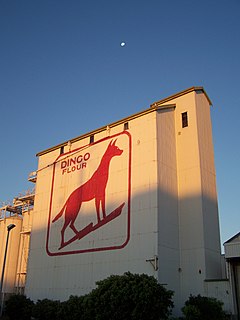
The Dingo Flour sign is a well-known landmark of a stylised silhouetted dingo in red on the side of an historic and heritage-listed working flour mill in North Fremantle, Western Australia.

The Esplanade Hotel is a hotel located opposite Esplanade Park in Fremantle, Western Australia. The building stands on the site of the first building used for housing convicts transported from Great Britain in 1850.

Kings Square, also known as King's Square, is a town square in Fremantle, Western Australia. It is bounded by Queen, Newman, William, and Adelaide Streets. Though the square was originally a public reserve, it has been the site of Saint John's Church of England since 1843, and the Fremantle Town Hall since 1887. High Street was extended through and beyond the square in the 1880s, but the portion through the square was closed off in the 1960s. Today Kings Square functions as a civic and cultural centre of Fremantle, with modern events taking place adjacent to the historic buildings.
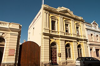
The Adelaide Steamship House is located at 10-12 Mouat Street, Fremantle. Built in 1900, the building was designed by Fremantle-based architectural firm Charles Oldham and Herbert Eales and was constructed by C. Coghill. The building takes its name from the original owners of the building, the Adelaide Steamship Company, who provided sea passenger and freight services around Australia.

The Adelec Buildings located at 28-36 High Street, on the corner of Henry Street in Fremantle, Western Australia. The heritage listed buildings were constructed in 1906 during the gold boom period by the trustees of Captain Edward Henry Fothergills estate.

The Marich Buildings is a single two-storey building at the corner of Henry and High Streets in Fremantle, Western Australia, and dates from c1897; there were several single-storey shops on the site including one occupied by butchers Henry Albert & Co.

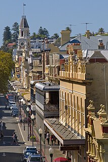
Mouat Street is a 300-metre-long (980 ft) street in Fremantle, Western Australia. Historically, the name was often spelled as Mouatt Street.

Wilhemsen House, also known as the Elders Building, Elder Building, Barwil House and the Dalgety & Co. Building, is a heritage building located at 11 Cliff Street on the corner of Phillimore Street in the port city of Fremantle, Western Australia. The building dates from the gold rush boom period in the late nineteenth and early twentieth centuries and is of historic significance.

Central Chambers is a heritage listed building located at 61-63 High Street on the corner of Pakenham Street in Fremantle, Western Australia. It was one of many commercial buildings constructed in Fremantle during the gold boom period in the late nineteenth and early twentieth century.

The Evan Davies Building, also known as the Literary Institute Building, is a heritage listed building located at 13 South Terrace, Fremantle on the corner with Collie Street. It was one of many buildings constructed in Fremantle during the gold boom period in the late nineteenth and early twentieth century.

Owston's Buildings, also known as Ouston's building, is a heritage listed building located at 9-23 High Street on the corner with Mouat Street in the Fremantle West End Heritage area. It was one of many buildings constructed in Fremantle during the gold boom period in the late nineteenth and early twentieth century.

The Tolley & Company Warehouse, also known as the Tolley Bond Store and the Tolley & Company Building, is a heritage building located at 1 Pakenham Street in the Fremantle West End Heritage area. It dates from the gold rush boom period in the late nineteenth and early twentieth centuries, and is of historic significance.
Stamp Museum is a museum in Ankara, Turkey.