| RSPB Dungeness | |
|---|---|
 | |
| Coordinates | 50°55′00″N0°58′00″E / 50.916667°N 0.966667°E |
RSPB Dungeness is a nature reserve owned and managed by the Royal Society for the Protection of Birds (RSPB)
| RSPB Dungeness | |
|---|---|
| | |
| Coordinates | 50°55′00″N0°58′00″E / 50.916667°N 0.966667°E |
RSPB Dungeness is a nature reserve owned and managed by the Royal Society for the Protection of Birds (RSPB)
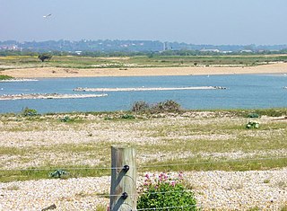
Dungeness headland is a cuspate foreland formed by longshore drift. It originally consisted of around 500 gravel beach ridges, although much of the structure has been lost due to centuries of gravel extraction. [1] and major storms in the 12th and 13th centuries.The oldest exposed ridges on the west of the headland date back about 5,000 years, whereas those to the east, by the power station were formed between 500 and 1000 years ago. The shelter provided by the gravel barrier enabled the formation of marshes and natural pools in its lee. [2]
The shingle is 98% flint and the exposed area covers 2,158 hectares (5,330 acres) with a further 1,150 hectares (2,800 acres) buried by alluvial deposits. The deposits can be up to 15 metres (49 ft) thick, with another 12 metres (39 ft) of mixed sand and gravel below that. [3]
Evidence of Bronze Age activity in the area includes a bronze axe, pottery fragments and worked flint. During the Romano-British period salt was made by taking saltwater trapped between the gravel ridges and heating it over fires. [1]
The reserve is accessible by car from Lydd 1.6 kilometres (0.99 mi) away. It is also connected to Route 2 (Dover to St Austell) of the Sustrans National Cycle Network by the Suffolk Coast Cycle route. The nearest bus access is in Lydd, and rail access is in Rye 16 kilometres (9.9 mi) distant [4] [5]
Entry to the reserve is free for RSPB members, although a fee is charged for non-members. The site is open daily from 9 am to sunset or 9 pm, which ever is later. Except for 25 and 26 December, it is open year-round. The visitor centre and facilities are open from 10 am and close at 4 pm from November to February, 5 pm the rest of the year. Only assistance dogs are allowed within the reserve; all other dogs must be kept within the car park on a lead. [6]
The visitor centre provides a café, picnic area, shop and toilets and baby-changing facilities; guided walks and binocular hire are also available. The main 3.2 kilometres (2.0 mi) circular nature trail and two 380 metres (1,250 ft) tracks from the trail to a bird hide and a viewing screen can be accessed by wheelchair and pushchair users, and all the hides can accommodate wheelchairs too. [7]
The Lade Pits site was donated to the RSPB by Cemex in 2015. The pits were created by the commercial extraction of four million tonnes of gravel and sand from the 70 hectares (170 acres) site. As well as habitats including open water, shingle and marshland, the site holds the Denge Sound Mirrors, large concrete structures built between 1928 and 1935. In the days before radar, they were intended to focus and amplify the sound of enemy aircraft approaching the coast, enabling early detection. All three are scheduled monuments. The site is open year round and access is free, although the island on which the sound mirrors stand can only be visited by prior arrangement. [8]
The site has Site of Special Scientific Interest (SSSI), Special Area of Conservation (SAC), Ramsar and Special Protection Area (SPA) status. [8]
Dungeness's location and range of habitats make it a major site for rare species. Notable recent occurrences include a short-toed treecreeper in 2015, Audouin's Gull and Blyth's reed warbler in 2014, [9] crested lark in 2012, [10] collared pratincole in 2011 and white-tailed lapwing in 2010. [11] [12]
Invertebrates include medicinal leeches and Sussex emerald moth, the latter being uncommon in the UK. [8]

Snettisham RSPB reserve is a nature reserve in the care of the Royal Society for the Protection of Birds, situated near Snettisham in the county of Norfolk, England, north of King's Lynn, and close to Sandringham. It faces The Wash, a large estuary. In autumn and winter, the big tides of the Wash pushes up hundreds of thousands of wading birds onto the Norfolk coast. The nature reserve's bird lagoons provide a safe habitat for them.

Romney Marsh is a sparsely populated wetland area in the counties of Kent and East Sussex in the south-east of England. It covers about 100 square miles (260 km2). The Marsh has been in use for centuries, though its inhabitants commonly suffered from malaria until the 18th century. Due to its location, geography and isolation, it was important for smugglers between the 17th and 19th centuries. The area has long been used for sheep pasture: Romney Marsh sheep are considered one of the most successful and important sheep breeds. Featuring numerous waterways, and with some areas lying below sea level, the Marsh has over time sustained a gradual level of reclamation, both through natural causes and by human intervention.

Lydd is a town and electoral ward in Kent, England, lying on Romney Marsh. It is one of the larger settlements on the marsh, and the most southerly town in Kent. Lydd reached the height of its prosperity during the 13th century, when it was a corporate member of the Cinque Ports, a "limb" of Romney. Located on Denge Marsh, Lydd was one of the first sandy islands to form as the bay filled in and evolved into what is now called Romney Marsh.

Dungeness is a headland on the coast of Kent, England, formed largely of a shingle beach in the form of a cuspate foreland. It shelters a large area of low-lying land, Romney Marsh. Dungeness spans Dungeness Nuclear Power Station, the hamlet of Dungeness, and an ecological site at the same location. It lies within the civil parish of Lydd.

RSPB Minsmere is a nature reserve owned and managed by the Royal Society for the Protection of Birds (RSPB) at Minsmere, Suffolk. The 1,000-hectare (2,500-acre) site has been managed by the RSPB since 1947 and covers areas of reed bed, lowland heath, acid grassland, wet grassland, woodland and shingle vegetation. It lies within the Suffolk Coast and Heaths Area of Outstanding Natural Beauty and the Suffolk Heritage Coast area. It is conserved as a Site of Special Scientific Interest, Special Area of Conservation, Special Protection Area and Ramsar site.

Gibraltar Point national nature reserve is an area of about 4.3 km2 (1.7 sq mi) on the coast of Lincolnshire, England.

Cemlyn Bay is a bay on the northwest coast of Anglesey, North Wales, approximately 2.5 km west of Wylfa nuclear power station, within the community of Cylch-y-Garn.
Royal Air Force Denge or more simply RAF Denge is a former Royal Air Force site near Dungeness, in Kent, England. It is best known for the early experimental acoustic mirrors which remain there.

RSPB Dearne Valley Old Moor is an 89-hectare (220-acre) wetlands nature reserve in the Dearne Valley near Barnsley, South Yorkshire, run by the Royal Society for the Protection of Birds (RSPB). It lies on the junction of the A633 and A6195 roads and is bordered by the Trans Pennine Trail long-distance path. Following the end of coal mining locally, the Dearne Valley had become a derelict post-industrial area, and the removal of soil to cover an adjacent polluted site enabled the creation of the wetlands at Old Moor.

Havergate Island is the only island entirely located within the county of Suffolk, England. It is found at the confluence of the River Ore and the Butley River near the village of Orford. It is a marshy nature reserve run by the Royal Society for the Protection of Birds (RSPB) and is known for its population of pied avocets and terns. It is part of the ecologically important Alde-Ore Estuary and has protected conservation status as part of a national nature reserve, SSSI, SAC, SPA, Ramsar Site and is also a part of the Suffolk Coast and Heaths AONB.

London Ashford Airport is 1 NM east of the town of Lydd and 12 NM south of Ashford in the district of Folkestone and Hythe, in Kent, England. Originally named Lydd Ferryfield, it is now also known as London Ashford Airport. The airport is operated by London Ashford Airport Ltd, controlled by Saudi businessman Fahad Al Athlel.

Cuspate forelands, also known as cuspate barriers or nesses in Britain, are geographical features found on coastlines and lakeshores that are created primarily by longshore drift. Formed by accretion and progradation of sand and shingle, they extend outwards from the shoreline in a triangular shape.
Middleton Lakes RSPB reserve is a 160 hectares nature reserve, formally opened on 19 May 2011, created and run by the Royal Society for the Protection of Birds at Middleton, Warwickshire, England, just south of Tamworth. The Northern part of the reserve lies in Staffordshire, yet the reserve is only a few minutes from the outskirts of Birmingham.
Dungeness, Romney Marsh and Rye Bay is a 10,172.9-hectare (25,138-acre) biological and geological Site of Special Scientific Interest which stretches from New Romney in Kent to Winchelsea in East Sussex. An area of 5,129.5 hectares is a Special Protection Area, an area of 3,141.1 hectares is a Special Area of Conservation, and an area of 6,377.6 hectares is a Ramsar Site, a wetland site designated of international importance under the Ramsar Convention. Part of the site is in the High Weald Area of Outstanding Natural Beauty, parts are Geological Conservation Review sites, part is a Local Nature Reserve, and part is a Royal Society for the Protection of Birds nature reserve, and part is a National Nature Reserve.

Ham Wall is an English wetland National Nature Reserve (NNR) 4 kilometres (2.5 mi) west of Glastonbury on the Somerset Levels. It is managed by the Royal Society for the Protection of Birds (RSPB). Since the last Ice Age, decomposing plants in the marshes of the Brue valley in Somerset have accumulated as deep layers of peat that were commercially exploited on a large scale in the twentieth century. Consumer demand eventually declined, and in 1994 the landowners, Fisons, gave their old workings to what is now Natural England, who passed the management of the 260 hectares Ham Wall section to the RSPB.

The North Norfolk Coast Site of Special Scientific Interest (SSSI) is an area of European importance for wildlife in Norfolk, England. It comprises 7,700 ha (19,027 acres) of the county's north coast from just west of Holme-next-the-Sea to Kelling, and is additionally protected through Natura 2000, Special Protection Area (SPA) listings; it is also part of the Norfolk Coast Area of Outstanding Natural Beauty (AONB). The North Norfolk Coast is also designated as a wetland of international importance on the Ramsar list and most of it is a Biosphere Reserve.

Cley Marshes is a 176-hectare (430-acre) nature reserve on the North Sea coast of England just outside the village of Cley next the Sea, Norfolk. A reserve since 1926, it is the oldest of the reserves belonging to the Norfolk Wildlife Trust (NWT), which is itself the oldest county Wildlife Trust in the United Kingdom. Cley Marshes protects an area of reed beds, freshwater marsh, pools and wet meadows and is part of the North Norfolk Coast Site of Special Scientific Interest (SSSI), Special Area of Conservation (SAC), Special Protection Area (SPA), and Ramsar Site due to the large numbers of birds it attracts.
Denge Marsh, also spelled Dengemarsh and occasionally called the Denge, is a part of Romney Marsh in Kent. Its north-west boundary is the town of Lydd; to the south-east is Denge Beach and Dungeness.
The Avalon Marshes Partnership is a group of conservation organisations working together in the Somerset Levels. The members are Natural England, the Royal Society for the Protection of Birds (RSPB), the Somerset Wildlife Trust, the Hawk and Owl Trust, Historic England, South West Heritage Trust and the Environment Agency. Between 2012 and 2016 the scheme was supported by a Heritage Lottery Fund grant of £1,772,500 with additional investment of £920,080 from other sources. The Avalon Marshes Centre, run by Natural England, is near the Shapwick Heath reserve. The network of reserves and private land managed for conservation in the Avalon marshes means that wetland management can be carried out on a landscape scale.

Rye Harbour LNR is a 325.4-hectare (804-acre) local nature reserve in Rye in East Sussex. The site is part of the 465-hectare (1,150-acre) nature reserve managed by the Sussex Wildlife Trust. It is also part of Dungeness, Romney Marsh and Rye Bay Ramsar site, Special Protection Area and Site of Special Scientific Interest and Dungeness Special Area of Conservation.