Raahe-Pattijoki Airfield

Last updated
Raahe-Pattijoki Airfield
Raahe-Pattijoen lentokenttä
Summary
Operator Raahen Ilmailukerho ry
Location Raahe, Finland
Elevation  AMSL 118 ft / 36 m
Coordinates 64°41′17″N024°41′45″E / 64.68806°N 24.69583°E / 64.68806; 24.69583 Coordinates: 64°41′17″N024°41′45″E / 64.68806°N 24.69583°E / 64.68806; 24.69583
Map
Finland adm location map.svg
Airplane silhouette.svg
EFRH
Location within Finland
Runways
Direction Length Surface
m ft
10/28 1,000 3,281 asphalt/gravel
Source: VFR Finland [1]

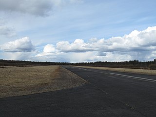
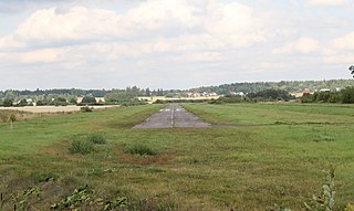
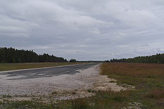
Raahe-Pattijoki Airfield( ICAO : EFRH) is an airfield in Raahe, Finland, about 9 kilometres (6 mi) east of Raahe town centre. [1]

ICAO airport code four-letter code designating many airports around the world

The ICAOairport code or location indicator is a four-letter code designating aerodromes around the world. These codes, as defined by the International Civil Aviation Organization and published in ICAO Document 7910: Location Indicators, are used by air traffic control and airline operations such as flight planning.

Raahe Town in North Ostrobothnia, Finland

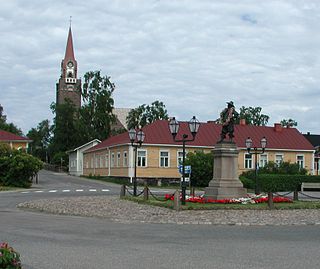
Raahe is a town and municipality of Finland. Founded by Swedish statesman and Governor General of Finland Count Per Brahe the Younger in 1649, it is one of 10 historic wooden towns remaining in Finland. Examples of other Finnish historic wooden towns are Kaskinen (Kaskö), Old Rauma, Porvoo (Borgå), Jakobstad (Pietarsaari), and Vaasa (Vasa). After a devastating fire in 1810, Raahe was rebuilt adhering to new design principles which minimized the risk of fire and enlarged some civic spaces. Old Raahe is noted for its Renaissance-inspired rectilinear town plan featuring an unusual central-square with closed corners.

Finland Republic in Northern Europe

Finland, officially the Republic of Finland, is a country in Northern Europe bordering the Baltic Sea, Gulf of Bothnia, and Gulf of Finland, between Norway to the north, Sweden to the northwest, and Russia to the east. Finland is a Nordic country and is situated in the geographical region of Fennoscandia. The capital and largest city is Helsinki. Other major cities are Espoo, Vantaa, Tampere, Oulu and Turku.

Contents

See also

Related Research Articles

Ahmosuo Airfield airfield in Oulu, Finland

Ahmosuo Airfield is an airfield in Hangaskangas, Oulu, Finland, about 20 kilometres (12 mi) southeast from Oulu city centre. The airfield was opened in 1987.

Alavus Airfield is an airfield in Alavus, Finland, about 2 nautical miles southwest of Alavus town centre.

Forssa Airfield airfield in Forssa, Finland

Forssa Airfield is an airfield in Forssa, Finland, about 2 kilometres (1.2 mi) southeast of Forssa town centre.

Haapavesi Airfield is an airfield in Haapavesi, Finland.

Hailuoto Airfield airfield in Hailuoto, Finland

Hailuoto Airfield is an airfield in Pöllä, Hailuoto, Finland, about 6 kilometres (4 mi) south of Hailuoto village.

Hanko Airfield airfield in Hanko, Finland

Hanko Airfield is the southernmost airfield in Finland. It is located in Hanko, about 8 kilometres (5 mi) east of Hanko city centre.

Ylivieska Airfield airfield in Ylivieska, Finland

Ylivieska Airfield is an aerodrome located in Vähäkangas, Ylivieska, Finland, about 10 kilometres (6 mi) east-southeast of Ylivieska town centre.

Kitee Airfield is an aerodrome in Kitee, Finland.

Kymi Airfield airfield in Kotka, Finland

Kymi Airfield is an airfield in Kotka, Finland. The Karhulan ilmailukerho Aviation Museum is located at the airfield.

Hyvinkää Airfield airfield in Hyvinkää, Finland

Hyvinkää Airfield is an airfield in Hyvinkää, Finland.

Jämijärvi Airfield airfield in Jämijärvi, Finland

Jämijärvi Airfield is an airfield in Jämijärvi, Finland, about 7 kilometres (4 mi) south of Jämijärvi municipal centre. It is one of the busiest general aviation airfields in Finland.

Hämeenkyrö Airfield is an airfield in Hämeenkyrö, Finland, about 7 nautical miles northwest of Hämeenkyrö centre.

Kemijärvi Airfield is an airfield in Kemijärvi, Finland, about 7 nautical miles west of Kemijärvi town centre.

Kiuruvesi Airfield is an airfield in Kiuruvesi, Finland, 2.7 nautical miles north of Kiuruvesi town centre. Kiuruvesi Airfield is considered one of the busiest airfields in the world.

Kivijärvi Airfield airfield in Kivijärvi, Finland

Kivijärvi Airfield is an airfield in Kivijärvi, Finland, about 1 nautical mile northeast of Kivijärvi centre.

Kumlinge Airfield airfield in Kumlinge, Åland, Finland

Kumlinge Airfield is an airfield in Kumlinge, Åland, Finland.

Kärsämäki Airfield is an airfield in Kärsämäki, Finland.

Rantasalmi Airfield is an airfield in Rantasalmi, Finland, about 2 nautical miles east of Rantasalmi municipal centre.

Pyhäsalmi Airfield is an airfield in Pyhäjärvi, Finland. It is located along the main road 4 (E75), about 8 kilometres (5 mi) north-northwest of Pyhäsalmi, the centre of Pyhäjärvi.

Pudasjärvi Airfield airfield in Pudasjärvi, Finland

Pudasjärvi Airfield is an airfield in Pudasjärvi, Finland, about 5 kilometres (3 mi) north-northwest from Kurenalus, the Pudasjärvi town centre.

References

  1. 1 2 "Raahe-Pattijoki, Finland – EFRH". VFR Suomi / Finland. Vantaa: Finavia. 18 November 2010. Archived from the original on 21 April 2012. Retrieved 8 August 2011.