Racks railway station

Last updated

Racks
Racks railway station, Dumfries. 1900.jpg
Racks station in 1900
General information
LocationDumfries, Dumfries and Galloway
Scotland
Platforms2
Other information
StatusDisused
History
Original company Glasgow, Dumfries and Carlisle Railway
Pre-grouping Glasgow and South Western Railway
Post-grouping LMS
Key dates
23 August 1848 [1] Opened
6 December 1965 [1] Closed
6 May 1964Closed to goods traffic

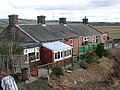
Racks railway station was a railway station in Dumfries and Galloway, Scotland, south of Dumfries, OS NGR NY 033 743, serving and effectively creating [2] the village of Racks near the Lochar Water, 4 miles ESE of Dumfries; a rural community within the Parish of Torthorwald. [3] [4]

Contents

History

The station, 62.64 miles south of Glasgow Saint Enoch station, opened in July 1848. [5] The station is now closed, although the line running through the station remains open. The station building has been converted into a private dwelling. The difference in height between the main building and platform level was overcome by the use of two fenced diagonal ramps built into the slope, with the remainder of the area occupied by a profusion of shrubbery and flower beds.

Racks station was opened by the Glasgow, Dumfries and Carlisle Railway, which then became part of the Glasgow and South Western Railway. In 1923, it became part of the London Midland and Scottish Railway at the Grouping, passing on to the Scottish Region of British Railways following the 1948 nationalisation of the railways. It had been a 'Wednesday Only' station since 1860 before becoming a fully open station on 2 January 1865. [6] It was closed by the British Railways Board under the Beeching Axe in 1965.

Services

Preceding station Historical railways Following station
Dumfries
Line open; station open
  Glasgow and South Western Railway
Glasgow, Dumfries and Carlisle Railway
  Ruthwell
Line open; station closed

Views of Racks in 2010

Related Research Articles

The Glasgow, Dumfries and Carlisle Railway was a railway company in Scotland, which constructed the line from near Cumnock to Gretna Junction, forming the route from Glasgow to Carlisle via Dumfries, in association with other lines. Its promoters hoped it would form the only railway between central Scotland and England, but it lost out to rival companies.

<span class="mw-page-title-main">Nitshill railway station</span> Railway station in Glasgow, Scotland

Nitshill railway station is situated in Nitshill, a district of Glasgow, Scotland. The station is managed by ScotRail and is on the Glasgow South Western Line, 5+34 miles (9.3 km) southwest of Glasgow Central.

<span class="mw-page-title-main">Barrhead railway station</span> Railway station of Barrhead, Greater Glasgow, Scotland

Barrhead railway station is a railway station in the town of Barrhead, East Renfrewshire, Greater Glasgow, Scotland. The station is managed by ScotRail and is on the Glasgow South Western Line, 7+12 miles (12.1 km) southwest of Glasgow Central.

The Glasgow and Paisley Joint Railway was the section of railway line between Glasgow Bridge Street railway station and Paisley, in the west of Scotland. It was constructed and operated jointly by two competing railway companies as the stem of their lines to Greenock and Ayr respectively, and it opened in 1840. The Joint Committee, which controlled the line, built a branch to Govan and later to Cessnock Dock, and then Prince's Dock.

The Paisley and Renfrew railway was an early Scottish railway company that constructed and operated a line between Paisley and the River Clyde at Renfrew Wharf, enabling journeys between Glasgow and Paisley by connecting river boat. The railway was built to the track gauge of 4 ft 6 in on stone block sleepers.

The Dalry and North Johnstone Line was a branch of the Glasgow and South Western Railway (G&SWR) in Renfrewshire and Ayrshire, Scotland, connecting the stations in Elderslie and Dalry via a route running parallel to the existing line built by the Glasgow, Paisley, Kilmarnock and Ayr Railway. This provided additional line capacity for Ayrshire Coast and Kilmarnock services. The loop line was used for passenger services until the mid-1960s, when it was closed by the Beeching Axe. The majority of the line's trackbed has since been absorbed into the Sustrans National Cycle Network.

The Greenock and Ayrshire Railway ran from Greenock, Scotland to Bridge of Weir, connecting there to the Glasgow and South Western Railway and making a through connection between Glasgow and Greenock. It closed progressively between 1959 and 1983.

The Glasgow, Barrhead and Kilmarnock Joint Railway was a railway jointly owned by the Caledonian Railway and the Glasgow and South Western Railway, completed in 1873, and giving the latter a shorter access to its Carlisle main line. A branch to Beith was also built.

<span class="mw-page-title-main">Catrine railway station</span> Railway station in East Ayrshire, Scotland, UK

Catrine railway station served the village of Catrine in East Ayrshire, Scotland. Open 1903–1943, except for a temporary closure, the station was the only one on the Catrine branch line of the Glasgow and South Western Railway (G&SWR).

The Largs Branch is a railway line in Scotland, serving communities on the north Ayrshire Coast, as well as the deep water ocean terminal at Hunterston. It branches from the Glasgow to Ayr line at Kilwinning.

The Ayr and Maybole Junction Railway (A&MJR) was a railway in Ayrshire, Scotland that provided services between Ayr and Maybole. It opened in 1856 and was seen as a link in providing a through line between Glasgow and Portpatrick, then the ferry port for the north of Ireland.

The Maybole and Girvan Junction Railway was a railway company that constructed a line between Maybole and Girvan. Although promoted independently, it was supported by the Glasgow and South Western Railway, and was seen as part of a trunk line connecting Glasgow with a ferry port for the north of Ireland.

Girvan and Portpatrick Junction Railway (G&PJR) was a railway company in Scotland. It opened in 1877 between Girvan and Challoch Junction, where it joined the Portpatrick Railway, which had already reached Stranraer from Castle Douglas. Portpatrick had been an important ferry terminal for traffic to and from the north of Ireland, but its significance was waning and Stranraer assumed greater importance. The new line formed part of a route between Glasgow, Ayr and Stranraer.

<span class="mw-page-title-main">Auldgirth railway station</span> Disused railway station in Auldgirth, Scotland

Auldgirth railway station was a station which served Auldgirth, in the Scottish county of Dumfries and Galloway. It was served by trains on what is now known as the Glasgow South Western Line north of Dumfries. The latter station is now the nearest to Auldgirth.

<span class="mw-page-title-main">Thornhill railway station (Scotland)</span> Former railway station in Scotland

Thornhill is a closed station. It served the country town of Thornhill in Dumfries and Galloway. The station site is a mile or so from the town. Four miles north of Thornhill is Drumlanrig Castle, home to the Duke of Buccleuch and Queensberry. The Glasgow and South Western main line rail route between Kilmarnock and Dumfries is forced to make a long detour to the east of Thornhill and through a long tunnel, rather than the more logical route nearer Thornhill town centre and up the Nith Valley, so as not to be seen from the Buccleuch estate. The distance of the station from Thornhill may be one reason that passenger use was light and stopping services ended in 1965. There was formerly a busy livestock market near to the station, which eventually closed around 2001.

<span class="mw-page-title-main">Ruthwell railway station</span> Former railway station in Scotland

Ruthwell railway station was a railway station in Dumfries and Galloway south of Dumfries, serving the village of Ruthwell with its famous 8th century carved cross; a rural community within the Parish of Ruthwell, lying a half-mile (1 km) north of Clarencefield and 1+14 miles (2.0 km) south southwest of Carrutherstown.

<span class="mw-page-title-main">Cummertrees railway station</span> Former railway station in Scotland

Cummertrees railway station was a railway station in Dumfries and Galloway south of Dumfries, serving the village of Cummertrees. The village lies some 3 miles (4.8 km) west of Annan and 12 miles (19 km) south of Lockerbie.

The Dumfries, Lochmaben and Lockerbie Railway was a railway in Dumfriesshire, Scotland. It connected Dumfries with Lockerbie via Lochmaben. Promoted independently, it was absorbed by the Caledonian Railway to give access to Dumfriesshire and later to Portpatrick for the Irish ferry service. It opened in 1863, closed to ordinary passenger services in 1952, and closed completely in 1966.

<span class="mw-page-title-main">Carronbridge railway station</span> Former railway station in Scotland

Carronbridge railway station was a railway station in Dumfries and Galloway north of Dumfries, serving the village of Carronbridge and district. The station lay a significant distance from the village of Carronbridge, however it also served a large rural area of scattered farms and cottages.

<span class="mw-page-title-main">Newbie Junction Halt railway station</span>

Newbie Junction Halt railway station was a railway station in Dumfries and Galloway, Scotland, located just west of Annan on the old Glasgow and South Western Railway main line that briefly served workers employed 0.5 mile or circa 800 metres away at the Cochran & Co. Boiler factory and the Newbie Brick and Tile Works at Newbie. The Newbie Siding branched off near the halt and was accessed from the west.

References

  1. 1 2 Butt 1995, p. 193.
  2. History of Torthorwald Church. Accessed : 2010-07-11
  3. "Racks railway station" . Retrieved 25 October 2009.
  4. "Ordnance Gazetteer for Scotland" . Retrieved 25 October 2009.
  5. Lindsay, David M. E. (2002). G&SWR Register of stations, routes & lines. G&SWR Association. Part 6.3, Page 20
  6. Stephenson Locomotive Society (1950). The Glasgow and South Western Railway. The Stephenson Locomotive Society. p. 12.

Sources

55°03′14″N3°30′53″W / 55.0540°N 03.5148°W / 55.0540; -03.5148