
The Aller is a 215-kilometre-long (134 mi) river in the states of Saxony-Anhalt and Lower Saxony in Germany. It is a right-hand, and hence eastern, tributary of the Weser and is also its largest tributary. Its last 117 kilometres (73 mi) form the Lower Aller federal waterway (Bundeswasserstraße). The Aller was extensively straightened, widened and, in places, dyked, during the 1960s to provide flood control of the river. In a 20-kilometre-long (12 mi) section near Gifhorn, the river meanders in its natural river bed.
Gifhorn is a district in Lower Saxony, Germany.
The Ohrekreis was a district (Kreis) in the north-east of Saxony-Anhalt, Germany. Neighboring districts are Altmarkkreis Salzwedel, Stendal, Jerichower Land, the district-free city Magdeburg, Bördekreis, and the districts Helmstedt and Gifhorn in Lower Saxony. Its territory is now incorporated into Börde.
The Ohre is a river in northern Germany, left tributary to the Elbe. Its total length is 103 kilometres (64 mi). Its source is north of Wolfsburg, in Lower Saxony. It flows generally south-east, at first following the border of Lower Saxony and Saxony-Anhalt. After Buchhorst it flows completely through Saxony-Anhalt, along the Mittellandkanal. It flows into the Elbe in Rogätz, north of Magdeburg. The towns Brome, Calvörde, Haldensleben and Wolmirstedt lie along the river. The upper course of the Ohre is in the Drömling nature reserve.

The Province of Hanover was a province of the Kingdom of Prussia and the Free State of Prussia from 1868 to 1946.

Wittingen is a town in the district of Gifhorn, Lower Saxony, Germany. It is about 30 kilometres (19 mi) northeast of Gifhorn, and 30 kilometres (19 mi) southeast of Uelzen.

Brome is a municipality in the district of Gifhorn, in Lower Saxony, Germany. It is situated on the river Ohre, approx. 25 km northeast of Wolfsburg.

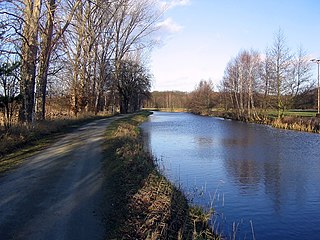
The Elbe Lateral Canal, is a 115-kilometre (71 mi) long canal in Lower Saxony, Germany. It runs from the Mittelland Canal near Gifhorn to the Elbe in Artlenburg. It forms an important transport connection between southern and northern Germany, and it provides a bypass of a section of the Elbe with limited navigability. At the construction start it was also thought as a bypass outside the GDR, considered politically unreliable.
The Osthannoversche Eisenbahnen AG (OHE) is a Celle based transportation company with railway network in North-eastern Lower Saxony around the Lüneburg Heath area of over 250 km.

The Lachte is a 38-kilometre-long (24 mi) right-hand tributary of the Aller in the Südheide Nature Park in the north German state of Lower Saxony.

Neudorf-Platendorf is a village in the municipality of Sassenburg in Gifhorn district in the German state of Lower Saxony. As of 2020, its population is about 2,800.

Drömling is a sparsely populated depression on the border of Lower Saxony and Saxony-Anhalt in Germany with an area of about 340 square kilometres (130 sq mi). The larger part belonging to Saxony-Anhalt in the east has been a nature park since 1990. The former swampland was transformed by drainage from a natural into a cultural landscape in the 18th century under the direction of Frederick the Great of Prussia. Today the depression, with its waterways, the Mittelland Canal and the rivers Aller and Ohre is a refuge for rare or endangered species of animal and plant. Most of the area is now made up of nature reserves and protected areas. Nearby towns include Oebisfelde and Wolfsburg.
The Aller Canal is a canal built in the mid-19th century in the German state of Lower Saxony. The canal is 18 kilometres (11 mi) long and runs between Wolfsburg and Gifhorn. It was built to protect agricultural land from flooding by the river Aller. The nearly straight canal carries water from the Aller more quickly than the river itself can in its meandering course through this section of the old glacial valley.

The Ise is a 43 km (27 mi) long, almost natural river of East Lower Saxony and Saxony-Anhalt, Germany. It crosses the district of Gifhorn from north to south and discharges into the Aller at Gifhorn itself.
Lower Saxon cuisine covers a range of regional, North German culinary traditions from the region correspondingly broadly to the state of Lower Saxony, which in many cases are very similar to one another, for example cuisine from the areas of Oldenburg, Brunswick, or East Frisia.
The Celle–Wittingen railway is a line belonging to the East Hanoverian Railways. Because its western portion runs along the River Lachte, it is also known as the Lachte Valley Railway (Lachtetalbahn).
The Celle–Wittingen Light Railway was founded on 21 June 1902 by the Prussian state, the town of Celle and 33 municipalities. On 15 August 1904 it opened the 51 km long, standard gauge line from Celle Stadt (Nord) via Beedenbostel and Hankensbüttel to Wittingen West. This line was also called the Lachte Valley Railway (Lachtetalbahn) because part of it ran along the river Lachte. The journey time on the Celle–Wittingen line in 1906 was about 2 hours and 20 minutes. In 1908 the station at Wittingen West was moved to the east side of the state station in order to enable a common station to be created with the Kleinbahn Wittingen-Oebisfelde, opened in 1909, and the Kleinbahn Bismark-Gardelegen-Wittingen, later the Altmärkische Kleinbahn AG. The new route made the construction of embankments and a bridge over the state railway necessary.
The Wittingen-Oebisfelde Light Railway was a railway company in Germany that operated passenger and goods trains on the 43 kilometre long Wittingen–Oebisfelde railway.
The village of Ohrdorf lies in the north German state of Lower Saxony in the district of Gifhorn and belongs to the town of Wittingen.
The village of Kakerbeck lies in the north German state of Lower Saxony in the district of Gifhorn. It is a village in the town of Wittingen.


