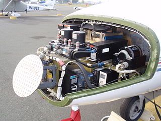
Avionics are the electronic systems used on aircraft. Avionic systems include communications, navigation, the display and management of multiple systems, and the hundreds of systems that are fitted to aircraft to perform individual functions. These can be as simple as a searchlight for a police helicopter or as complicated as the tactical system for an airborne early warning platform.

Loran-C is a hyperbolic radio navigation system that allows a receiver to determine its position by listening to low frequency radio signals that are transmitted by fixed land-based radio beacons. Loran-C combined two different techniques to provide a signal that was both long-range and highly accurate, features that had been incompatible. Its disadvantage was the expense of the equipment needed to interpret the signals, which meant that Loran-C was used primarily by militaries after it was introduced in 1957.

Navigation is a field of study that focuses on the process of monitoring and controlling the movement of a craft or vehicle from one place to another. The field of navigation includes four general categories: land navigation, marine navigation, aeronautic navigation, and space navigation.

Very high frequency (VHF) is the ITU designation for the range of radio frequency electromagnetic waves from 30 to 300 megahertz (MHz), with corresponding wavelengths of ten meters to one meter. Frequencies immediately below VHF are denoted high frequency (HF), and the next higher frequencies are known as ultra high frequency (UHF).

An emergency position-indicating radiobeacon (EPIRB) is a type of emergency locator beacon for commercial and recreational boats, a portable, battery-powered radio transmitter used in emergencies to locate boaters in distress and in need of immediate rescue. In the event of an emergency, such as a ship sinking or medical emergency onboard, the transmitter is activated and begins transmitting a continuous 406 MHz distress radio signal, which is used by search-and-rescue teams to quickly locate the emergency and render aid. The signal is detected by satellites operated by an international consortium of rescue services, COSPAS-SARSAT, which can detect emergency beacons anywhere on Earth transmitting on the distress frequency of 406 MHz. The satellites calculate the position or utilize the GPS coordinates of the beacon and quickly passes the information to the appropriate local first responder organization, which performs the search and rescue. As Search and Rescue approach the search areas, they use Direction Finding (DF) equipment to locate the beacon using the 121.5 MHz homing signal, or in newer EPIRBs, the AIS location signal. The basic purpose of this system is to help rescuers find survivors within the so-called "golden day" during which the majority of survivors can usually be saved. The feature distinguishing a modern EPIRB, often called GPIRB, from other types of emergency beacon is that it contains a GPS receiver and broadcasts its position, usually accurate within 100 m (330 ft), to facilitate location. Previous emergency beacons without a GPS can only be localized to within 2 km (1.2 mi) by the COSPAS satellites and relied heavily upon the 121.5 MHz homing signal to pin-point the beacons location as they arrived on scene.

Radio navigation or radionavigation is the application of radio frequencies to determine a position of an object on the Earth, either the vessel or an obstruction. Like radiolocation, it is a type of radiodetermination.
A distress signal, also known as a distress call, is an internationally recognized means for obtaining help. Distress signals are communicated by transmitting radio signals, displaying a visually observable item or illumination, or making a sound audible from a distance.
The Global Maritime Distress and Safety System (GMDSS) is a worldwide system for automated emergency signal communication for ships at sea developed by the United Nations' International Maritime Organization (IMO) as part of the SOLAS Convention.

A search and rescue transponder (SART) is a self-contained, waterproof transponder intended for emergency use at sea. These devices may be either a radar-SART, or a GPS-based AIS-SART.

The automatic identification system (AIS) is an automatic tracking system that uses transceivers on ships and is used by vessel traffic services (VTS). When satellites are used to receive AIS signatures, the term Satellite-AIS (S-AIS) is used. AIS information supplements marine radar, which continues to be the primary method of collision avoidance for water transport. Although technically and operationally distinct, the ADS-B system is analogous to AIS and performs a similar function for aircraft.

Differential Global Positioning Systems (DGPSs) supplement and enhance the positional data available from global navigation satellite systems (GNSSs). A DGPS for GPS can increase accuracy by about a thousandfold, from approximately 15 metres (49 ft) to 1–3 centimetres.

The International Cospas-Sarsat Programme is a satellite-aided search and rescue (SAR) initiative. It is organized as a treaty-based, nonprofit, intergovernmental, humanitarian cooperative of 45 nations and agencies. It is dedicated to detecting and locating emergency locator radio beacons activated by persons, aircraft or vessels in distress, and forwarding this alert information to authorities that can take action for rescue. Member countries support the distribution of distress alerts using a constellation of around 65 satellites orbiting the Earth which carry transponders and signal processors capable of locating an emergency beacon anywhere on Earth transmitting on the Cospas-Sarsat frequency of 406 MHz.
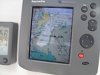
A Chartplotter is a device used in marine navigation that integrates GPS data with an electronic navigational chart (ENC).

In navigation, a radio beacon or radiobeacon is a kind of beacon, a device that marks a fixed location and allows direction-finding equipment to find relative bearing. But instead of employing visible light, radio beacons transmit electromagnetic radiation in the radio wave band. They are used for direction-finding systems on ships, aircraft and vehicles.

Radio is the technology of signaling and communicating using radio waves. Radio waves are electromagnetic waves of frequency between 3 hertz (Hz) and 3,000 gigahertz (GHz). They are generated by an electronic device called a transmitter connected to an antenna which radiates the waves, and received by another antenna connected to a radio receiver. Radio is widely used in modern technology, in radio communication, radar, radio navigation, remote control, remote sensing, and other applications.

In radio navigation, a VOR/DME is a radio beacon that combines a VHF omnidirectional range (VOR) with a distance-measuring equipment (DME). The VOR allows the receiver to measure its bearing to or from the beacon, while the DME provides the slant distance between the receiver and the station. Together, the two measurements allow the receiver to compute a position fix.

The AIS-SART is a self-contained radio device used to locate a survival craft or distressed vessel by sending updated position reports using a standard Automatic Identification System (AIS) class-A position report. The position and time synchronization of the AIS-SART are derived from a built in GNSS receiver . Shipboard Global Maritime Distress Safety System (GMDSS) installations include one or more search and rescue locating devices. These devices may be either an AIS-SART, or a radar-SART.
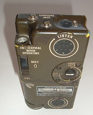
Survival radios are carried by pilots and search and rescue teams to facilitate rescue in an emergency. They are generally designed to transmit on international distress frequencies. Maritime systems have been standardized under the Global Maritime Distress Safety System. Civil and military organisation's utilized different frequencies to communicate and no infringement on either sector would take place. For emergencies involving civilian aircraft, the radio frequency used is VHF 121.5 MHz and for military aircraft incidents, the frequency used is UHF 243 MHz.
An emergency locator beacon is a radio beacon, a portable battery powered radio transmitter, used to locate airplanes, vessels, and persons in distress and in need of immediate rescue. Various types of emergency locator beacons are carried by aircraft, ships, vehicles, hikers and cross-country skiers. In case of an emergency, such as the aircraft crashing, the ship sinking, or a hiker becoming lost, the transmitter is deployed and begins to transmit a continuous radio signal, which is used by search and rescue teams to quickly find the emergency and render aid. The purpose of all emergency locator beacons is to help rescuers find survivors within the so-called "golden day", the first 24 hours following a traumatic event, during which the majority of survivors can usually be saved.
RTCM SC-104 is a communication protocol for sending differential GPS (DGPS) to a GPS receiver from a secondary source like a radio receiver. The standard is named for the Special Committee 104 of the Radio Technical Commission for Maritime Services (RTCM) that created it. The format does not define the source of the messages and has been used with systems as varied as longwave marine radio, communications satellite broadcasts, and internet distribution.