
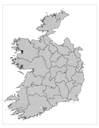
County Tipperary is a county in Ireland. It is in the province of Munster and the Southern Region. The county is named after the town of Tipperary, and was established in the early 13th century, shortly after the Norman invasion of Ireland. It is Ireland's largest inland county and shares a border with eight counties, more than any other. The population of the county was 159,553 at the 2016 census. The largest towns are Clonmel, Nenagh and Thurles.

North Tipperary was a county in Ireland. It was part of the Mid-West Region and was also located in the province of Munster. It was named after the town of Tipperary and consisted of 48% of the land area of the traditional county of Tipperary. North Tipperary County Council was the local authority for the county. In 2011, the population of the county was 70,322. It was abolished on 3 June 2014, merged with South Tipperary under a new Tipperary County Council.

South Tipperary was a county in Ireland. It was part of the South-East Region and was also located in the province of Munster. It was named after the town of Tipperary and consisted of 52% of the land area of the traditional county of Tipperary. South Tipperary County Council was the local authority for the county. The population of the county was 88,433 according to the 2011 census. It was abolished on 3 June 2014, merged with North Tipperary under a new Tipperary County Council.
A townland is a small geographical division of land, historically and currently used in Ireland and in the Western Isles in Scotland, typically covering 100–500 acres (40–202 ha). The townland system is of Gaelic origin, pre-dating the Norman invasion, and most have names of Irish origin. However, some townland names and boundaries come from Norman manors, plantation divisions, or later creations of the Ordnance Survey. The total number of inhabited townlands in Ireland was 60,679 in 1911. The total number recognised by the Irish Place Names database as of 2014 was 61,098, including uninhabited townlands, mainly small islands.
An electoral division is a legally defined administrative area in the Republic of Ireland, generally comprising multiple townlands, and formerly a subdivision of urban and rural districts. Until 1996, EDs were known as district electoral divisions in the 29 county council areas and wards in the five county boroughs. Until 1972, DEDs also existed in Northern Ireland. The predecessor poor law electoral divisions were introduced throughout the island of Ireland in the 1830s. The divisions were used as local-government electoral areas until 1919 in what is now the Republic and until 1972 in Northern Ireland.
A poor law union was a geographical territory, and early local government unit, in the United Kingdom and Ireland.
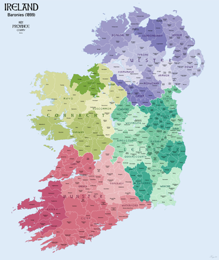
In Ireland, a barony is a historical subdivision of a county, analogous to the hundreds into which the counties of England were divided. Baronies were created during the Tudor reconquest of Ireland, replacing the earlier cantreds formed after the original Norman invasion. Some early baronies were later subdivided into half baronies with the same standing as full baronies.
The 1911 Census of Ireland was the last census that covered the whole island of Ireland. Censuses were taken at ten-year intervals from 1821 onwards, but the 1921 census was cancelled due to the Irish War of Independence.
The Irish Poor Laws were a series of Acts of Parliament intended to address social instability due to widespread and persistent poverty in Ireland. While some legislation had been introduced by the pre-Union Parliament of Ireland prior to the Act of Union, the most radical and comprehensive attempt was the Irish act of 1838, closely modelled on the English Poor Law of 1834. In England, this replaced Elizabethan era legislation which had no equivalent in Ireland.

Civil parishes are units of territory in the island of Ireland that have their origins in old Gaelic territorial divisions. They were adopted by the Anglo-Norman Lordship of Ireland and then by the Elizabethan Kingdom of Ireland, and were formalised as land divisions at the time of the Plantations of Ireland. They no longer correspond to the boundaries of Roman Catholic or Church of Ireland parishes, which are generally larger. Their use as administrative units was gradually replaced by Poor Law Divisions in the 19th century, although they were not formally abolished. Today they are still sometimes used for legal purposes, such as to locate property in deeds of property registered between 1833 and 1946.

Moycarkey is an electoral division in County Tipperary in Ireland. It was originally an electoral division in the Thurles Poor Law Union in North Tipperary but is still used for various administrative purposes.

Thurles Poor Law Union, was an Irish Poor law union officially declared on 28 March 1839. It covered an area of 195 square miles (510 km2), mostly in North Tipperary but also including some of South Tipperary. Although the boundaries of some poor law unions changed during the course of the 19th century, the Thurles union seems to have retained its original boundaries.

Buolick is a civil parish in County Tipperary, Ireland. It is one of nineteen civil parishes in the barony of Slievardagh. Buolick, also sometimes written as Boolick or Baolick, is also an electoral division in County Tipperary. The electoral division, originally in the Thurles Poor Law Union, is largely coterminous with Buolick civil parish. The village of Gortnahoo lies within the civil parish.

Ballymurreen, sometimes written Ballymoreen, is an electoral division in County Tipperary in Ireland. The code number assigned it by the Central Statistics Office is 22062.

Littleton is an electoral division in County Tipperary in Ireland. The code number assigned it by the Central Statistics Office is 22071.

Originally called Burris poor law electoral division, and sometimes called Borrisleigh in the past, this electoral division in County Tipperary in Ireland is now known as Twomileborris.
Rathmanna is a townland containing just over 45 acres in Rahelty civil parish in County Tipperary. It should not be confused with the much larger townland of the same name just across the border in Borrisleigh civil parish.
Rathmanna is a townland containing just over 240 acres in Borrisleigh civil parish in County Tipperary. It should not be confused with the much smaller townland of the same name just across the border in Rahelty civil parish.

Garraun is a townland, containing a little over 567 acres, in Twomileborris civil parish in County Tipperary.
Harristown is a civil parish and electoral division (ED) in County Kildare in Ireland, about 4 miles (6.4 km) southwest of Kildare town.
