Related Research Articles

Son River is a perennial river located in central India. It originates near Amarkantak Hill in Gaurela-Pendra-Marwahi district of Chhattisgarh and finally merges with the Ganges River near Patna in Bihar. The Sone River is the second-largest southern tributary of the Ganges after the Yamuna River. India's oldest river bridge Koilwar Bridge over Sone River connects Arrah with Patna. Sone river is famous for its sand across country. Multiple dam(s) and hydro-electric projects run on its course towards Ganges.
Araria is a city and a municipality that is the headquarters of Araria district in the Indian state of Bihar. Araria is situated in the northern part of Bihar.

Munger, formerly spelt as Monghyr, is a twin city and a Municipal Corporation situated in the Indian state of Bihar. It is the administrative headquarters of Munger district and Munger Division. Munger was one of the major cities in Eastern India and undivided Bengal during Mughal period and British Raj. It is one of the major political,cultural,educational and commercial center of Bihar and Eastern India. Munger is situated about 180km from east of capital city Patna, about 480km west of Eastern India's largest city kolkata and 1200km from country's capital New Delhi.

Saharsa is a city and Municipal corporation in the Saharsa District in the eastern part of the state of Bihar, India. It is situated near the eastern banks of the Kosi River. It serves as the administrative headquarters for Saharsa District and is also the Divisional Headquarter of the Kosi Division.

Hajipur is the headquarters and largest city of Vaishali district of the state of Bihar in India. Hajipur is the 16th most populous city of Bihar, besides being the second-fastest developing city, next to Patna. It had a total population of 1.47 lakh as per census 2011. Vaishali district is ranked 8th among 38 districts in Bihar in terms of growth.
The East Central Railway is one of the 19 railway zones in India. It is headquartered at Hajipur and comprises Sonpur, Samastipur, Danapur, Pt. Deen Dayal Upadhyaya, and Dhanbad divisions.

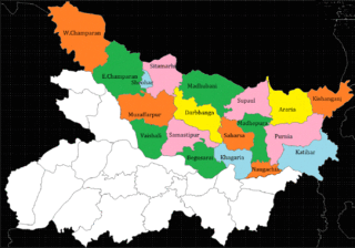
Khagaria district is an administrative district in the state of Bihar in India. The district headquarters are located at Khagaria. Earlier it was a part of Munger District as a sub-division that was created in 1943–44. It was upgraded to the status of a district on 10 May 1981. Khagaria district is a part of Munger Division.
Mohania is a city and corresponding community development block in Kaimur district of Bihar, India. It serves as headquarters for the Mohania sub-division in Kaimur district. It is 17 km (11 mi) by road north of the city of Bhabua, at the intersection of National Highway 19, National Highway 219, and National Highway 319. The bank of the Durgavati River is just to the south of Mohania. The total block population was 218,479, in 32,198 households.
Located in eastern India, Bihar is the twelfth-largest Indian state, with an area of 94,163 km2 (36,357 mi2) and an average elevation of about 150 metres above mean sea level. The landlocked state shares a boundary with Nepal to the north, the state of West Bengal to the east, Jharkhand to the south, and Uttar Pradesh to the west. Bihar lies in a subtropical temperate zone and its climatic type is humid subtropical.
Simri Bakhtiyarpur is a subdivision and town in the Saharsa district of Bihar state, India.

The Kanwar Taal or Kabar Taal Lake or Kabartal Wetland located in Begusarai district of Bihar, India, is Asia's largest freshwater oxbow lake. It is approximately six times the size of the Bharatpur Sanctuary. In November 2020, the Ministry of Environment, Forest and Climate Change (MoEFCC) declared it the first Ramsar site in Bihar. There are a total of 75 Ramsar Sites in India till 2022.

Jamalpur Junction railway station, station code JMP, is the railway station serving the Munger–Jamalpur twin cities in the Munger district in the Indian State of Bihar.

Shri Krishna Setu is a rail-cum-road bridge across the Ganges, at Munger in the Indian state of Bihar and named after first Chief Minister of Bihar Shri Krishna Singh. The bridge connects the Munger-Jamalpur twin cities in Munger District to various districts of North Bihar. Srikrishna Setu Munger Ganga Bridge is the third rail-cum-road bridge over Ganga in Bihar.
The Barauni–Katihar, Saharsa and Purnia sections of the Barauni–Guwahati line connects Barauni, Saharsa, Purnia and Katihar in the Indian state of Bihar.
North Bihar is a term used for the region of Bihar, India, which lies north of the Ganga river.
The state of Bihar has a number of bridges, extending from few metres to a few kilometres. The history of long bridges goes back to the British Empire when the site for the Koilwar bridge was surveyed in 1851. Since then a number of small and large bridges have crept up. Some are even largest of their kind. Mahatma Gandhi Setu, joining Patna and Hajipur was India's longest river bridge from 1982 to 2017.
Rajdham is a village in Gogari block of Khagaria district of Bihar State, India.

2017 Bihar floods affected 19 districts of North Bihar causing death of 514 people. 2,371 panchayats under 187 blocks of 19 districts of Northern Bihar have been affected in the flood. Around 1.71 crore people were hit by the floods. Over 8.5 lakhs of people have lost their homes, with Araria district alone accounting for 2.2 lakh homeless people. 2017 Flood has broken 9-Year record of deaths In Bihar. Bihar is India's most flood-prone State, with 76% of the population in the North Bihar living under the recurring threat of flood devastation. Devastating flood was caused due to excess heavy rainfall in monsoon season.

Ratanpur railway station is a railway station on Sahibganj loop line under the Malda railway division of Eastern Railway zone. It is situated at Itahari, Ratanpur in Munger district in the Indian state of Bihar.
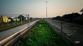
Umeshnagar railway station is a railway station under the Sonpur railway division of East Central Railway. Umeshnagar station is located in Rahimpur Panchayat of Khagaria district in the Indian state of Bihar. There are three platforms and 14 halting trains at this station. The station is named after local freedom fighter and Congress politician Umeshwar Prasad.
References
- ↑ "Block map - State : BIHAR - District : KHAGARIA - Block Name : KHAGARIA" (PDF). National Informatics Centre (NIC). Retrieved 6 September 2021.
- ↑ Singh, Santosh (20 April 2020). "Bihar: Khagaria farmers find no buyers for their wheat amid Covid-19 lockdown". The Indian Express. Retrieved 6 September 2021.
- ↑ "COVID-19: Defunct Rural Health Centres Highlight Desperate Situation in Bihar". NewsClick. 2021-05-21. Retrieved 2021-06-19.
- ↑ "Bihar Polls: Years of Apathy Keep Khagaria Residents Dependent on Boats for Transport". NewsClick. 2020-11-01. Retrieved 2021-06-19.
- ↑ "Two years left and the blind chase of toilets continues". www.downtoearth.org.in. Retrieved 2021-06-19.
- ↑ "खगड़िया:उप-स्वास्थ्य केंद्र है बदहाल, तबेले में तब्दील". www.kashishnews.com/. Retrieved 2021-06-19.
- ↑ "Bihar: Rivers Cross Danger Mark | The Weather Channel - Articles from The Weather Channel | weather.com". The Weather Channel. Retrieved 2021-06-19.
- ↑ "Global goal, local fight". www.downtoearth.org.in. Retrieved 2021-06-19.
- ↑ Thakur, N. P.; Tripathi, Piyush (September 6, 2018). "Rivers in spate, flood threat looms over Bihar". The Times of India. Retrieved 2021-06-19.
- ↑ "Khagaria's long wait for 'complete' Ganga bridge". Hindustan Times. 2015-10-01. Retrieved 2021-06-19.