
Fife is a council area, historic county, registration county and lieutenancy area of Scotland. It is situated between the Firth of Tay and the Firth of Forth, with inland boundaries with Perth and Kinross and Clackmannanshire. By custom it is widely held to have been one of the major Pictish kingdoms, known as Fib, and is still commonly known as the Kingdom of Fife within Scotland. A person from Fife is known as a Fifer. In older documents the county was very occasionally known by the anglicisation Fifeshire.

Kirkcaldy is a town and former royal burgh in Fife, on the east coast of Scotland. It is about 11.6 miles (19 km) north of Edinburgh and 27.6 miles (44 km) south-southwest of Dundee. The town had a recorded population of 49,460 in 2011, making it Fife's second-largest settlement and the 12th most populous settlement in Scotland.

Kinghorn is a town and parish in Fife, Scotland. A seaside resort with two beaches, Kinghorn Beach and Pettycur Bay, plus a fishing port, it stands on the north shore of the Firth of Forth, opposite Edinburgh. According to the 2008 population estimate, the town has a population of 2,930.

Culross (/ˈkurəs/) is a village and former royal burgh, and parish, in Fife, Scotland.

Cowdenbeath is a town and burgh in west Fife, Scotland. It is 5 miles (8 km) north-east of Dunfermline and 18 miles (29 km) north of the capital, Edinburgh. The town grew up around the extensive coalfields of the area and became a police burgh in 1890. According to a 2008 estimate, the town has a population of 14,081.

Raith Rovers Football Club is a Scottish professional football club based in the town of Kirkcaldy, Fife. The club was founded in 1883 and currently competes in the Scottish Championship as a member of the Scottish Professional Football League.

Kirkcaldy and Cowdenbeath is a county constituency representing the areas around the towns of Kirkcaldy and Cowdenbeath, in Fife, Scotland, in the House of Commons of the Parliament of the United Kingdom. It is currently represented by Alba Party politician Neale Hanvey.

Kirkcaldy was a county constituency of the House of Commons of the Parliament of the United Kingdom in Fife, returning one Member of Parliament (MP). It existed from the February 1974 election until its abolition in 2005.

Valleyfield consists of High Valleyfield and Low Valleyfield which are neighbouring villages in Fife, Scotland, midway between Dunfermline and Kincardine-on-Forth. Low Valleyfield is on the shore of the Firth of Forth, High Valleyfield on the ridge immediately to the north.

Auchtertool is a small village in Fife, Scotland. It is 4 miles west of Kirkcaldy. The name is from the Gaelic uachdar, meaning upland or heights above the Tiel burn. The Tiel Burn flows a few hundred yards south of the kirk and village, which was formerly known as Milton of Auchtertool. The parish belonged to the diocese of Dunkeld, having been given to Bishop Gregory by King David I in the twelfth century. Soon after, the church was given to the priory of Inchcolm.

Hallyards Castle, located to the north-west of the village of Auchtertool, is reputed to have been a hunting seat of Malcolm Canmore. With the establishment of the Roman Church, Halyards became the local residence of the Bishops of Dunkeld; it remained so until the first lay proprietor took possession in 1539.

Crossgates is a village in Fife, Scotland. It is located close to the junction of the M90 and A92, about two miles east of Dunfermline and a similar distance south west of Cowdenbeath. The village name means 'crossroads': it is situated at the point where the main Dunfermline-Kirkcaldy road crosses the old Great North Road from Inverkeithing to Perth.

Tulliallan was an estate in Perthshire, Scotland, near to Kincardine, and a parish. The Blackadder lairds of Tulliallan, a branch of the Blackadder border clan, wielded considerable power in the 15th and 16th centuries. The modern Tulliallan Castle is relatively recent, built in 1812-1820 and now the home of the Scottish Police College

Duloch, or Duloch Park, is a residential suburb of Dunfermline, in Fife, Scotland.
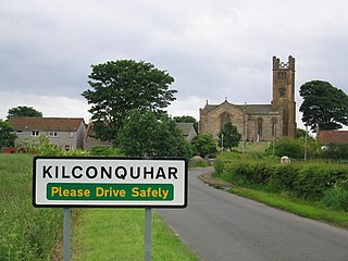
Kilconquhar is a village and parish in Fife in Scotland. It includes the small hamlet of Barnyards. It is bounded by the parishes of Elie, Ceres, Cameron, St Monans, Carnbee, Newburn and Largo. It is approximately 9 miles from north to south. Much of the land is agricultural or wooded. The village itself is situated inland, north of Kilconquhar Loch. Also in the civil parish are Colinsburgh and Largoward, the latter since 1860 being a separate ecclesiastical parish.

Ballingry ; Scots: Ballingry, Bingry, Scottish Gaelic: Baile Iongrach) is a small town in Fife, Scotland. It is near the boundary with Perth and Kinross, north of Lochgelly. It has an estimated population (2016) of 5,940. The once separate villages of Ballingry, Lochore, Crosshill, and Glencraig are now somewhat joined together as the part of the Benarty area. Ballingry, along with its neighbour Lochgelly, is one of Fife's 'regeneration areas' and is classed as in need of regeneration economically and socially.

Dunfermline was a local government district in the Fife region of Scotland from 1975 to 1996, lying to the south-west of the regional capital Glenrothes.

The Howe of Fife is the broad, low-lying valley of the River Eden, lying between the Ochil Hills and the Lomond Hills in Fife, Scotland. Howe, in Scots means a hollow or a plain bounded by hills. The alternative terms Laich of Fife and the Valley of Eden have fallen from use, as has Stratheden, save for the hospital near Cupar.

Scoonie is a settlement and parish in Fife, Scotland, the parish contains the town of Leven. It is bordered on the north by the parishes of Kettle and Ceres, on the east by the parish of Largo, on the south by the parishes of Markinch and Wemyss, and on the west by the parishes of Markinch and Kennoway. It extends about 4+1⁄2 miles north to south. Its width varies between 5⁄8 and 2+3⁄4 mi . The parish is on the coast of the Firth of Forth, with a coastline of about 1+1⁄2 mi (2.4 km) The area of the parish is 4,107 acres.

Cameron is a parish in east Fife, Scotland, 3½ miles south-west of St Andrews.

