Meghalaya is a state in northeastern India. The name means "the abode of clouds" in Sanskrit. The population of Meghalaya as of 2016 is estimated to be 3,211,474. Meghalaya covers an area of approximately 22,430 square kilometers, with a length to breadth ratio of about 3:1.

Dispur is the capital of the state of Assam in India.

East Garo Hills is an administrative district in the state of Meghalaya in India.
The Khasi Hills are part of the Garo-Khasi range in the Indian state of Meghalaya, and is part of the Patkai range and of the Meghalaya subtropical forests ecoregion. In older sources in particular, the alternative transcription Khasia Hills is seen.
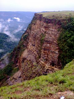
Balpakram National Park is a national park at about 3000ft. above sea level, near the Garo Hills in Meghalaya, India. Balpakram is located between latitudes 25°20' N and 25°30' N, and longitudes 90°45' E to 91° E. The Balpakram National Park is located to the extreme South of Garo Hills, Meghalaya at a distance of 62 km from Baghmara, the district headquarters of South Garo Hills and 167 km from nearest major townTura. This pocket of pristine beauty named Balpakram National Park is also close to the international boundary of Bangladesh. It is often compared to the Grand Canyon National Park of United States. It is often referred to as the "abode of perpetual winds" as well as the "land of spirits. It is believed that here, the spirits of the dead dwell temporarily before embarking on the final journey. Balpakram is sacred to the Garos as the abode of the dead spirits." It is the home of the barking deer and the golden cat. Commonly seen animals include wild water buffalo, red panda, elephant and eight species of cats including tiger and marbled cat. Balpakram, land of the eternal wind, according to Garo myth, has a very beautiful landscape and one of the best Canyon around the region. It is famous for unique land formations with surround the mythological stories of the Garos. Declared a national park by the Government of India, it is now a protected place and permission has to be sought from the wildlife authorities before entering. It has some unique plants species including the ones mentioned and the corridor for the Indian elephant. Balpakram was inaugurated as a National Park on 27 December 1987.
The Meghalaya subtropical forests is a montane subtropical moist broadleaf forest ecoregion of eastern India. The ecoregion covers an area of 41,700 square kilometers (16,100 sq mi), encompassing the Khasi Hills, Garo Hills, and Jaintia Hills of India's Meghalaya state, and adjacent portions of Assam state. The ecoregion is one of the most species-rich in India with a rich diversity of birds, mammals, and plants.

The following outline is provided as an overview of, and topical guide to, India:
The Government of Meghalaya also known as the State Government of Meghalaya, is the supreme governing authority of the Indian state of Meghalaya and its 11 districts. It consists of an executive, led by the Governor of Meghalaya, a judiciary and a legislative branch.

The National People's Party is a state-level political party in India, though its influence is mostly concentrated in the state of Meghalaya. The party was founded by P A Sangma after his expulsion from the NCP in July 2012.

The Meghalaya Legislative Assembly is a unicameral legislature in the government of the state of Meghalaya in India. Constituted as a directly elected body in 1972, it has 60 members, filled through direct elections held every five years. Like other Indian states, Meghalaya has a parliamentary system of government. The executive branch of the Meghalaya Government is derived from the Legislative Assembly.

Conrad Kongkal Sangma is an Indian politician who is the 12th and current Chief Minister of the State of Meghalaya. He assumed presidency of the National People's Party in 2016 after the death of his father and former Chief Minister Purno Sangma. He was also the Member of Parliament from Tura(2016-2018).
Evansius Kek Mawlong was an Indian politician who served as the Chief Minister of Meghalaya from 8 March 2000, until 8 December 2001. He was the main architect in the formation of the United Democratic Party in Meghalaya and was its Founding President.
Cherra Companyganj State Railways (CCSR) was a narrow gauge mountain railway that existed in British India.
CMJ University or CMJU is a private university located in Jorabat, Meghalaya, India. Created through a state act in 2009, it is the first private university established in Meghalaya. The campus is situated on a 40-acre campus on a hillock in Jorabat on the Guwahati-Shillong Highway.
National Highway 217 commonly referred to as NH 217, is a national highway in India. This route was earlier part of old national highways 51 and 62. It is a secondary route of National Highway 17. NH-217 runs through the states of Assam and Meghalaya in India.

The Insurgency in Meghalaya is a neutralized armed conflict between India and a number of separatist rebel groups which was taking place in the state of Meghalaya. The Insurgency in Meghalaya is part of the wider Insurgency in Northeast India, and was fueled by demands of the Khasi, Synteng and Garo people for a separate state.
Wansuk Syiem is a politician. She is a Member of Parliament, representing Meghalaya State in the Rajya Sabha for the second term of 2014-2020.
The Meghalaya Legislative Assembly election was held on 27 February 2018 to elect 59 of 60 members to the Meghalaya Legislative Assembly, with the results declared on 3 March. The scheduled election in Williamnagar constituency was delayed to an undetermined date following the death of Nationalist Congress Party candidate Jonathone Sangma in an IED blast in East Garo Hills district on February 18, 2018. The incumbent Indian National Congress government, led by Chief Minister Mukul Sangma attempted to win a re-election for the third time in a row.
National Highway 127B, commonly called NH 127B is a National Highway in North East India that connects Srirampur in Assam to Nongston in Meghalaya.