Mizoram is a state in northeastern India, with Aizawl as its capital city. The name is derived from "Mizo", the name of the native inhabitants, and "Ram", which means land, and thus Mizoram means "land of the Mizos". Within the northeast region, it is the southernmost landlocked state, sharing borders with three of the Seven Sister States, namely Tripura, Assam and Manipur. The state also shares a 722 kilometre border with the neighbouring countries of Bangladesh and Myanmar.

Mamit is a census town in Mamit district in the Indian state of Mizoram. Mamit emerged from the regrouping of villages.
Thenzawl is a census town in Serchhip district in the Indian state of Mizoram. It is an important center for the traditional Mizo handloom industry. Thenzawl is located at 90 km(56 miles) away from Aizawl, the capital of Mizoram.

Aizawl district is one of the eight districts of Mizoram state in India. The district is bounded on the north by Kolasib district, on the west by Mamit district, on the south by Serchhip district, on the southwest by Lunglei district and on the east by Champhai district. The district occupies an area of 3,577 square kilometres (1,381 sq mi). The headquarters of the district is Aizawl city, the capital of Mizoram. As of 2011 it is the most populous district of Mizoram.

Lunglei district is one of the eight districts of Mizoram state in India. As of 2011 it is the second most populous district in the state, after Aizawl. It is also the largest district in Mizoram with an area of 4,572 km2(1,765 sq mi).

Mamit district is one of the eight districts of Mizoram state in India.

Serchhip District is one of the eight districts of Mizoram state in India. The district occupies an area of 1421.60 km². Serchhip town is the administrative headquarters of the district. This district came into existence on 15 September 1998, being carved out of the larger Aizawl District. Because of the way it was created it includes part of East Lungdar Tehsil and part of Thingsulthliah Tehsil.

Lawngtlai district is one of the eight districts of Mizoram state in India. The district is bounded on the north by Lunglei district, on the west by Bangladesh, on the south by Myanmar and on the east by Saiha district. The district occupies an area of 2557.10 km². Lawngtlai town is the administrative headquarters of the district.

The Kaladan River is a river in eastern Mizoram State of India, and in Chin State and Rakhine State of western Myanmar. The Kaladan River is called the Chhimtuipui River in India. It forms the international border between India and Burma between 22° 47′ 10" N and 22° 11′ 06" N.

The Government of Mizoram also known as the State Government of Mizoram, or locally as State Government, is the supreme governing authority of the Indian state of Mizoram and its 8 districts. It consists of an executive, led by the Governor of Mizoram, a judiciary and a legislative branch.
The Government of Tripura also known as the State Government of Tripura, or locally as State Government, is the supreme governing authority of the Indian state of Tripura and its 8 districts. It consists of an executive, led by the Governor of Tripura, a judiciary and a legislative branch.
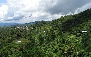
North Lungpher is a village in Mizoram, India. North Lungpher is a medium size village located in Thingsulthliah RD Block of Aizawl district, Mizoram, with about 200 families residing there.
The Thega River is a river lying mostly between eastern Bangladesh and Mizoram, India. The Thega River flows northwards and exits into the Karnaphuli River at 22°52′43″N92°26′52″E. Its originates from Myanmar(Burma) and is one of the main tributaries of the Karnafuli.
Government Serchhip College is a government college in Serchhip Town in the Indian state of Mizoram. The College is affiliated to Mizoram University. It is graded B+ status by NAAC. Serchhip College at present has 405 students.

Regional Institute of Paramedical and Nursing Sciences (RIPANS) is located at Zemabawk, Aizawl on the slope of a hill generously donated by the government of Mizoram.

Govt. Zirtiri Residential Science College is the only institution that offers purely science education in the State of Mizoram. It is graded B by NAAC and has students 608 currently studying in the college.
Academy of Integrated Christian Studies is an ecumenical seminary situated in Aizawl, Mizoram. It is affiliated to the Senate of Serampore College (University). The College is owned and operated by the Baptist Church of Mizoram.
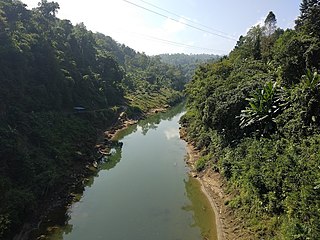
The Tlawng is a river of Mizoram, northeastern India. Its tributaries include the Tut, Teirei and the Ngashih. The city of Aizawl lies in the Tlawng valley.

Government Aizawl North College is an educational institution located in Ramhlun Venglai, the northern part of Aizawl, Mizoram. The college is affiliated with Mizoram University As of 2014, it has 1120 students. The college's principal is Mr. Vanlalduha. The College at present has 1,309 students, 28 teachers and 12 non-teaching staff.

The Mizoram State Museum is in Aizawl, Mizoram, India. It is an ethnographic museum with multipurpose collections on display. There are five galleries: Textile Gallery, Ethnology, History, Anthropology, Natural History, and Archeology Terrace. The collection occupies four floors.