Warsaw, officially the Capital City of Warsaw, is the capital and largest city of Poland. The metropolis stands on the River Vistula in east-central Poland. Its population is officially estimated at 1.86 million residents within a greater metropolitan area of 3.27 million residents, which makes Warsaw the 7th most-populous city in the European Union. The city area measures 517 km2 (200 sq mi) and comprises 18 districts, while the metropolitan area covers 6,100 km2 (2,355 sq mi). Warsaw is classified as an alpha global city, a major cultural, political and economic hub, and the country's seat of government. It is also the capital of the Masovian Voivodeship.

Masovian Voivodeship or Mazowieckie Province or Mazowieckie Voivodeship or Mazovian Voivodeship or Mazovian Province, etc. is a voivodeship (province) in east-central Poland, containing Poland's capital Warsaw.
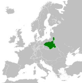
The Duchy of Warsaw, also known as the Grand Duchy of Warsaw and Napoleonic Poland, was a French client state established by Napoleon Bonaparte in 1807, during the Napoleonic Wars. It initially comprised the ethnically Polish lands ceded to France by Prussia under the terms of the Treaties of Tilsit, and was augmented in 1809 with territory ceded by Austria in the Treaty of Schönbrunn. It was the first attempt to re-establish Poland as a sovereign state after the 18th-century partitions and covered the central and southeastern parts of present-day Poland.
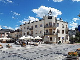
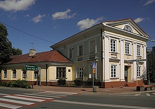
Piaseczno is a town in east-central Poland with 47,660 inhabitants. It is situated in the Masovian Voivodeship, within the Warsaw metropolitan area, just south of Warsaw, approximately 16 kilometres south of its center. It is a residential area and a suburb of Warsaw. It is the capital city of Piaseczno County.

Zawiercie ( ) is a town in southern Poland located in the Silesian Voivodeship with 49,334 inhabitants (2019). It is situated in the Kraków-Częstochowa Upland near the source of the Warta River. The town lies near the historical region of Silesia, but belongs to Lesser Poland.

Ryki is a town in the Lublin Voivodeship in eastern Poland, capital of Ryki County. It has 9,767 inhabitants. It is situated between Warsaw and Lublin. Ryki belongs to Lesser Poland, and historically is part of Ziemia Stężycka. The distance to the Polish capital is 100 km, the distance to Lublin – 64 km.

Operation Tempest or Operation Burza was a series of uprisings conducted during World War II against occupying German forces by the Polish Home Army, the dominant force in the Polish resistance.
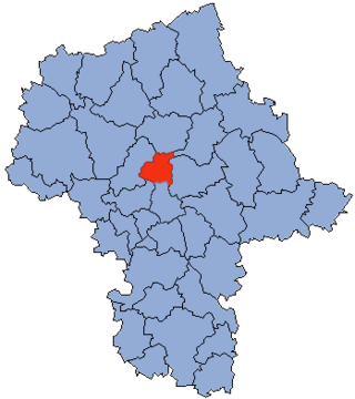
Legionowo County is a unit of territorial administration and local government (powiat) in Masovian Voivodeship, east-central Poland. It came into being on 1 January 1999 as a result of the Polish local government reforms passed in 1998. Its administrative seat and largest town is Legionowo, which lies 22 kilometres (14 mi) north of Warsaw. The only other town in the county is Serock, lying 17 km (11 mi) north-east of Legionowo.
Grójec is a town in eastern Poland, located in the Masovian Voivodeship, about 40 kilometres south of Warsaw. It is the capital of the urban-rural administrative district Grójec and Grójec County. It has 16,674 inhabitants (2017). Grójec surroundings are considered to be the biggest apple-growing area of Poland. It is said that the region makes up also for the biggest apple orchard of Europe. Statistically, every third apple sold in Poland is grown in Grójec – a unique local microclimate provides for their beautiful red colour.
Masovian Voivodeship was an administrative region of the Kingdom of Poland, and of the Polish–Lithuanian Commonwealth, from 1526 to the partitions of the Polish–Lithuanian Commonwealth to 1795. Together with Płock and Rawa Voivodeships, it formed the province of Masovia. Its area was divided into ten lands. The seat of the voivode was Warsaw, local sejmiks also convened in Warsaw, at St. Martin's church.

Wójcin is a village in the administrative district of Gmina Jeziora Wielkie, within Mogilno County, Kuyavian-Pomeranian Voivodeship, in central Poland. It is chiefly agricultural and has about 800 inhabitants.
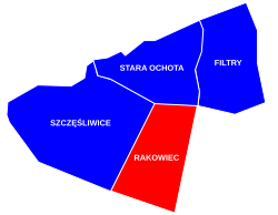
Augustówka is a neighbourhood, and an area of the City Information System, in the city of Warsaw, Poland, located within the district of Mokotów.

Świekatowo is a village in Świecie County, Kuyavian-Pomeranian Voivodeship, in north-central Poland. It is the seat of the gmina called Gmina Świekatowo. It lies approximately 23 kilometres (14 mi) west of Świecie and 35 km (22 mi) north of Bydgoszcz. It is located in the Tuchola Forest in the historic region of Pomerania.

Sadki is a village in Nakło County, Kuyavian-Pomeranian Voivodeship, in north-central Poland. It is the seat of the gmina called Gmina Sadki. It lies approximately 11 kilometres (7 mi) west of Nakło nad Notecią and 38 km (24 mi) west of Bydgoszcz.
The Nangar Khel incident, sometimes called the Nangar Khel massacre, took place in the Afghan village of Nangar Khel on August 16, 2007. A few hours after an insurgent IED ambush which damaged Polish wheeled armored vehicle, a patrol of Polish soldiers from the elite 18th Airborne-Assault Battalion taking part in the International Security Assistance Force opened heavy machine gun and 60 mm mortar fire at the area of the village. The attack resulted in the deaths of 6 civilians, including a pregnant woman and 3 children, and seriously injured 3 other women.
Dąbrówka is a village in Wołomin County, Masovian Voivodeship, in east-central Poland. It is the seat of the gmina called Gmina Dąbrówka. It lies approximately 16 kilometres (10 mi) north of Wołomin and 36 km (22 mi) north-east of Warsaw.
Zdziechowa is a village in the administrative district of Gmina Gniezno, within Gniezno County, Greater Poland Voivodeship, in west-central Poland. It lies approximately 6 kilometres (4 mi) north of Gniezno and 49 km (30 mi) north-east of the regional capital Poznań.

Biadki is a village in the administrative district of Gmina Krotoszyn, within Krotoszyn County, Greater Poland Voivodeship, in west-central Poland. It lies approximately 9 kilometres (6 mi) east of Krotoszyn and 92 km (57 mi) south-east of the regional capital Poznań.
Dopiewiec is a village in the administrative district of Gmina Dopiewo, within Poznań County, Greater Poland Voivodeship, in west-central Poland. It lies approximately 3 kilometres (2 mi) east of Dopiewo and 15 km (9 mi) west of the regional capital Poznań.
Kowalewo-Sołectwo is a village in the administrative district of Gmina Słupca, within Słupca County, Greater Poland Voivodeship, in west-central Poland.