Sirdal is a municipality in Agder county, Norway. It is located in the northwestern part of the traditional district of Lister. The administrative centre of the municipality is the village of Tonstad. Other villages in Sirdal include Bjørnestad, Haughom, Kvæven, Lunde, and Tjørhom.

Rauma is a municipality in Møre og Romsdal county, Norway. It is part of the traditional district of Romsdal. The administrative centre is the town of Åndalsnes. Other settlements in Rauma include the villages of Måndalen, Innfjorden, Veblungsnes, Verma, Isfjorden, Eidsbygda, Rødven, Åfarnes, and Mittet. Most settlement in the municipality is located along the fjords and in the Romsdalen valley.

Aurland is a municipality in the county of Vestland, Norway. It is located on the south side of the Sognefjorden in the traditional district of Sogn. The administrative center is the village of Aurlandsvangen. Other villages include Bakka, Flåm, Undredal, and Gudvangen.

Holtålen is a municipality in Trøndelag county, Norway. It is part of the Gauldalen region. The administrative centre of the municipality is located in the Ålen area of the village of Renbygda. Other villages in the municipality include Hessdalen, Aunegrenda, and Haltdalen.

Saltdal is a municipality in Nordland county, Norway. It is part of the traditional district of Salten. The administrative centre of the municipality is the village of Rognan. Other villages in Saltdal include Røkland, Lønsdal, Langset, and Saksenvika.

The Rauma is a river that runs through Romsdalen, a valley in Møre og Romsdal and Innlandet counties in Norway. It runs for 68 kilometres (42 mi) from Lesjaskogsvatnet, a lake in the municipality of Lesja, to the town of Åndalsnes in the municipality of Rauma. The river was once famous for its salmon-fishing, but since an infection with Gyrodactylus salaris only 5 to 10% of the original stock survives. This, however, has begun to recover rapidly after a successful revitalisation project. The salmon runs up to the Slettafossen, a 16-metre (52 ft) high combination of waterfalls and rapids more than 42 kilometres (26 mi) upriver from the estuary.

The Bergen Line, or the Bergen Railway, is a 371-kilometre (231 mi) long scenic standard gauge railway line between Bergen and Hønefoss, Norway. The name is often applied to the entire route from Bergen to Oslo, including the Randsfjord and Drammen lines between Hønefoss and Oslo, covering a total distance of 496 kilometres (308 mi). It is the highest mainline railway line in Northern Europe, crossing the Hardangervidda plateau at 1,237 metres (4,058 ft) above sea level.

The Sognefjord or Sognefjorden, nicknamed the King of the Fjords, is the largest and deepest fjord in Norway. Located in Vestland county in Western Norway, it stretches 205 kilometres (127 mi) inland from the ocean to the small village of Skjolden in the municipality of Luster.
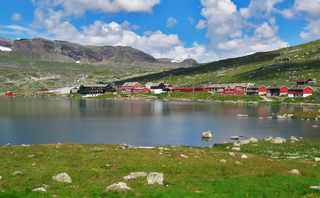
Geilo is a centre in the municipality of Hol in Buskerud county, Norway. Geilo is primarily a ski resort town, with around 2,500 inhabitants. It is situated in the valley of Hallingdal, 250 km from Oslo and 260 km from Bergen. The Bergen Line facilitated Geilo's development as the first skiing resort in the country, and it is still one of the largest. It is also known for having some of the most luxurious and expensive holiday cabins in Norway. The center of the town lies at 800 meters above sea level, and its highest point is 1178 meters above sea level.

is a town in Sel Municipality in Innlandet county, Norway. The town is also the administrative centre of the municipality. The town is located at the confluence of the Gudbrandsdalslågen and Otta rivers. The European route E6 highway runs through the town. The Dovrebanen railway line also passes through the town, stopping at the Otta Station. The 2.13-square-kilometre (530-acre) town has a population (2021) of 2,283 and a population density of 1,073 inhabitants per square kilometre (2,780/sq mi).

Flåm is a village in the Flåmsdalen valley which is located at the inner end of the Aurlandsfjorden, a branch of Sognefjorden. The village is located in Aurland Municipality in Vestland county, Norway. In 2014 its inhabitants numbered 350.
Finse is a locality in the mountainous north-east of Ulvik municipality in Vestland county, Norway. Located on lake Finsevatnet, it is centered around Finse station, a railway station on the Bergen Line, which is the highest station of the Norwegian railway system at an elevation of 1,222 metres (4,009 ft) above sea level. As it is not reachable by road, and as the municipality is not otherwise connected by rail, Finse is not easily accessible from the rest of Ulvik or from elsewhere in the Hardanger region. According to Statistics Norway, the basic statistical unit of Finse-Hallingskeid, which includes several other nearby localities such as Hallingskeid station, had a population of 10 in 2023.

The Flåm Line is a 20.2-kilometer (12.6 mi) long railway line between Myrdal and Flåm in Aurland Municipality, in Vestland county, Norway. A branch line of the Bergen Line, it runs through the valley of Flåmsdalen and connects the mainline with Sognefjord. The line's elevation difference is 866 meters (2,841 ft); it has ten stations, twenty tunnels and one bridge. The maximum gradient is 5.5 percent (1:18). Because of its steep gradient and picturesque nature, the Flåm Line is now almost exclusively a tourist service and has become the third-most visited tourist attraction in Norway.

Myrdal Station is a mountain railway station and junction, located on the Bergen Line regional mainline in Aurland, Vestland, Norway. The railway station is also the upper terminal of the Flåm Line local railway, which ascends from the valley floor of the Sognefjord to the mountain-top junction, providing a vital public transport link, but deriving a majority of its passengers through tourism. Most passengers using Myrdal station are changing trains between the two lines.

Viddalsdammen is a lake and a reservoir in Aurland Municipality in Vestland county, Norway. The reservoir has an area of 4.13-square-kilometre (1.59 sq mi) and the elevation varies between 930 metres (3,050 ft) and 868 m (2,848 ft) above sea level. Viddalsdammen is located at the end of the Låvisdalen valley, about 11 kilometres (6.8 mi) southeast of the village of Aurlandsvangen, about 7 kilometres (4.3 mi) southeast of the village of Flåm, and about 6 kilometres (3.7 mi) northeast of Myrdal Station.
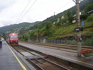
The Voss Line is a railway line from Bergen to Voss in Vestland, Norway. It opened on 11 July 1883 and was extended to Oslo as the Bergen Line on 27 November 1909. It was built as 1,067 mm narrow gauge, but converted to 1,435 mmstandard gauge with the connection with the Bergen Line. It was electrified in 1954, and shortened by the Ulriken Tunnel in 1963.
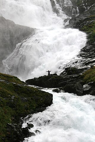
Kjosfossen is a waterfall located in Aurland Municipality in Vestland county, Norway. The waterfall is one of the most visited tourist attractions in Norway. Its total fall is around 225 metres (738 ft). There is a small power station on the waterfall which is used to power the Flåm Line railway.

Flåmselvi or Moldåni is a 40-kilometre (25 mi) long river in Vestland county, Norway. The river begins as runoff from the Omnsbreen glacier about 5 kilometres (3.1 mi) northwest of Finse in Ulvik Municipality. The river is known as the Moldåni river in this area. It then flows through a series of lakes heading to the northwest where it crosses into Aurland Municipality. The Bergen Line follows the river to Myrdal. At Myrdal, the river goes over the Kjosfossen waterfall and it follows Flåmsdalen valley and heads to the north. When it reaches the village of Flåm, it empties into Aurlandsfjorden, a branch off the main Sognefjorden.

Flåmsdalen is a valley in Aurland Municipality in Vestland county, Norway. It is 18 kilometers (11 mi) long and runs from Myrdal to the village of Flåm, dropping 860 meters (2,820 ft) over the course of its run. The river Flåmselvi runs through the valley, as does the Flåm Line, a famous tourist destination.

Reinunga Station is a railway station in Aurland, Norway, on the Flåm Line that links Flåm to Myrdal and the Oslo-Bergen train line. It is 2.20 kilometers (1.37 mi) from Myrdal Station, 338.00 kilometers (210.02 mi) from Oslo Central Station and 767 meters (2,516 ft) above mean sea level. The station opened in 1942.