Ramaroshan Site

Last updated
Ramarosan Lake
Ramaroshan lake 2.JPG
Nepal rel location map.svg
Red pog.svg
Ramarosan Lake
Location Achham, Nepal
Coordinates 29°13′55.95″N81°28′9.67″E / 29.2322083°N 81.4693528°E / 29.2322083; 81.4693528 Coordinates: 29°13′55.95″N81°28′9.67″E / 29.2322083°N 81.4693528°E / 29.2322083; 81.4693528
Type fresh water lake
Basin  countriesNepal
Surface area1,000 ha (2,500 acres)
Designations

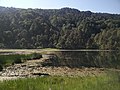
Ramaroshan is located in Achham district of Nepal at the altitude of 2500m. [1] A place having 18 patch of meadows (locally known as patans), is a major tourism site of Achham district. This area is the one of the habitat of national bird of Nepal, Danfe (Lophophorus). [2] A good view of Budhiganga basin, along with the peaks of Mount Api, and Mount Saipal can be seen from Ramaroshan area.

Contents

Introduction

Ramaroshan is a main attraction of Achham District. It is known as land of 12 lakes and 18 patch of meadows (grassland) (Nepali : बाह्र बण्ड, अठार खण्ड) with stiff rocky cliffs. Jigale lake is the largest lake in this area which has the shape of English letter C whereas Taune lake is the smallest one. Among the 18 patans, Kinemine patan is the largest patan, possibly the largest patan in the Achham District through which the Kailash river flows. This place is surrounded by a forest. Terraced hill slopes with lush green landscape surrounding the enchanting Ramaroshan Lake attracts everyone. On the route to this destination, travellers come across the forest of Rhododendron. Boating has been started since 2020 and people can encounter Himalayan Munal{National bird of Nepal}

Flora

Many species of plants are found in Ramaroshan area. Mostly lakes have been covered by various types of flowers. Many wild animals graze in the grassland of Ramaroshan.

Fauna

It is a habitat of various wild animal i.e. bear, wild cat, musk deer etc. Ramaroshan is also a habitat for various birds like lophophorous, pheasant, cuckoo etc.

See also

Related Research Articles

Jaldapara National Park National park in India

Jaldapara National Park is a national park (2012) (www.jaldaparanationalprk.org) situated at the foothills of the Eastern Himalayas in Alipurduar District of northern West Bengal, India, and on the banks of the Torsa River. Jaldapara is situated at an altitude of 61 m and is spread across 216.51 km2 (83.59 sq mi) of vast grassland with patches of riverine forests. It was declared a sanctuary in 1941 for protection of its great variety of flora and fauna.

Chitwan National Park National park in Nepal

Chitwan National Park is the first national park of Nepal. It was established in 1973 and was granted the status of a World Heritage Site in 1984. It covers an area of 952.63 km2 (367.81 sq mi) and is located in the subtropical Inner Terai lowlands of south-central Nepal in the districts of Nawalpur, Parasi, Chitwan and Makwanpur. In altitude it ranges from about 100 m (330 ft) in the river valleys to 815 m (2,674 ft) in the Sivalik Hills.

Achham District District in Sudurpashchim Province, Nepal

Achham is a district located in Sudurpashchim province of Nepal. It is one of the nine districts of the province. The district, with Mangalsen as its district headquarters, covers an area of 1,692 km2 and has a population (2011) of 257,477.

Surkhet District District of Nepal in Karnali Province

Surkhet District is a district in Karnali Province of mid-western Nepal. Surkhet is the one of the ten districts of Karnali located about 600 kilometres (373 mi) west of the national capital Kathmandu. The district's area is 2,489 square kilometres (961 sq mi). It had 288,527 population in 2001 and 350,804 in 2011 which male comprised 169,461 and female 181,381. Its district headquarters, Birendranagar, is the capital of Karnali Province. It is serving as a business hub and document center for Karnali province. According to population, development, road links, landforms, climate, many peoples are migrating here. after becoming province capital developmental activities are boosted and are in peak level. all the governmental works are carried here. Birendranagar is beautiful valley surrounded by hills having moderate climate.

Valmiki National Park National park and wildlife sanctuary in Bihar, India

Valmiki National Park is a Tiger Reserve in the West Champaran District of Bihar, India. It is the only national park in Bihar. Valmiki Tiger Reserve covers 898.45 km2 (346.89 sq mi), which is 17.4% of the total geographical area of the district. As of 2018, there were 40 tigers in the Reserve.

Terai–Duar savanna and grasslands

The Terai–Duar savanna and grasslands is a narrow lowland ecoregion at the base of the Himalayas, about 25 km (16 mi) wide, and a continuation of the Indo-Gangetic Plain in India, Nepal and Bhutan. It is colloquially called Terai in the Ganges Basin east to Nepal, then Dooars in West Bengal, Bhutan and Assam east to the Brahmaputra River. It harbours the world's tallest grasslands, which are the most threatened and rare worldwide.

Himalayan subtropical pine forests

The Himalayan subtropical pine forests are a large subtropical coniferous forest ecoregion covering portions of Bhutan, India, Nepal, and Pakistan.

Khaptad National Park is a protected area in the Far-Western Region, Nepal that was established in 1984. Stretching over the four districts of Bajhang, Bajura, Achham and Doti it covers an area of 225 km2 (87 sq mi) and ranges in elevation from 1,400 m (4,600 ft) to 3,300 m (10,800 ft).

India is home to a large variety of wildlife. It is a biodiversity hotspot with its various ecosystems ranging from the Himalayas in the north to the evergreen rain forests in the south, the sands of the west to the marshy mangroves of the east. India lies within the Indomalayan realm and is the home to about 7.6% of mammal, 14.7% of amphibian, 6% of bird, 6.2% of reptilian, and 6.0% of flowering plant species. India's forest lands nurture about 500 species of mammals and more than 2000 bird species.

Pilibhit Tiger Reserve

Pilibhit Tiger Reserve is located in Pilibhit district of Uttar Pradesh and was notified as a tiger reserve in 2014. It forms part of the Terai Arc Landscape in the upper Gangetic Plain along the India-Nepal border. The habitat is characterized by sal forests, tall grasslands and swamp maintained by periodic flooding from rivers. The Sharda Sagar Dam extending up to a length of 22 km (14 mi) is on the boundary of the reserve.

Kedarnath Wild Life Sanctuary, also called the Kedarnath Musk Deer Sanctuary, is a wildlife sanctuary declared under Wildlife Protection Act, 1972 and located in Uttarakhand, India. Its alternate name comes from its primary purpose of protecting the endangered Himalayan musk deer. Consisting of an area of 975 km2 (376 sq mi), it is the largest protected area in the western Himalayas.It is famous for alpine musk deer, Himalayan Thar, Himalayan Griffon, Himalayan Black bear, Snow Leopard and other flora park and fauna. It is internationally important for the diversity of its flora and fauna.

Barun Valley

Barun Valley is a Himalayan valley situated at the base of Mt. Makalu in the Sankhuwasabha district of Nepal. This valley rests entirely inside the Makalu Barun National Park.

Karian Shola National Park is a protected area in the Western Ghats, India, nominated as a national park in 1989. The Western Ghats are a chain of mountains running down the west of India parallel with the coast some 30 to 50 km inland. They are not true mountains, but the edge of a fault that resulted about 150 million years ago as the subcontinent of India split from Gondwanaland. They are older than the Himalayan mountain range and are clothed in ancient forests. They influence the weather in India as they intercept the incoming monsoon storm systems. The greatest rainfall occurs between June and September during the southwest monsoon, with lesser amounts falling in the northeast monsoon between October and November. The Western Ghats are a UNESCO World Heritage Site and are considered to be one of the eight most important "hotspots" of biological diversity in the world.

Western Himalayan broadleaf forests

The Western Himalayan broadleaf forests is a temperate broadleaf and mixed forest ecoregion which is found in the middle elevations of the western Himalayas, including parts of Nepal, India, and Pakistan.

Jigme Singye Wangchuck National Park

Jigme Singye Wangchuck National Park covers an area of 1,730 square kilometres (670 sq mi) in central Bhutan. It protects a large area of the Black Mountains, a sub−range of the Himalayan Range System.

The Barandabhar forest covers an area of 87.9 km2 and bisects the Chitwan District in east and west Chitwan. Barandabhar, a 29 km long forest patch, is bisected by the Mahendra Highway, resulting in a 56.9 km2 area in the buffer zone of RCNP and 31 km2 is under the district forest office.

Pangolakha Wildlife Sanctuary is a wildlife reserve in the Pakyong District of the state of Sikkim in India. It is about 28 kilometres (17 mi) east of Rorathang and about 40 kilometres (25 mi) by road from Rangpo city. The total notified area of the park is around 124 square kilometres (48 sq mi) while inside the wildlife sanctuary there are a few hamlets: Aritar, Dakline Lingtam, Phadamchen, Dzuluk, Gnathang Monastery Kupup. This wildlife sanctuary is linked to the forests of Neora Valley National Park of West Bengal as well as forests of Samtse, Bhutan and Haa district Bhutan. The area that comes under this biosphere has been declared in 1999 as a wildlife sanctuary under biogeographic province category 2C.

Naina Devi Himalayan Bird Conservation Reserve is a wildlife reserve in the Nainital district of the state of Uttarakhand in India. This reserve forest is located in Kumaon region of Uttarakhand and placed inside Nainital forest division. Nainital forest division at present has several birding trails and forest patches consisting of temperate broad-leaf forests to alpine grasslands to rhododendron shrubberies. Wide altitudinal variation supports a very large segment of avian fauna to inhibit in this forest range.

Khingan Nature Reserve

Khingan Nature Reserve is a Russian 'zapovednik', located in the extreme south-east of the Amur River region of the Russian Far East. The reserve covers two types of habitat: the flat Arkharinskaya lowlands with abundant wetlands, and forested spurs of the Lesser Khingan mountains. In particular, Khingan Reserve was created to protect steppe and forest-steppe landscapes, and nesting sites of the endangered Red-crowned crane and the vulnerable White-naped crane. The reserve is situated in the Arkharinsky District of Amur Oblast.

Khanka Nature Reserve

Khanka Nature Reserve is a Russian 'zapovednik' that covers portions of the shore and waters of Lake Khanka, the largest freshwater lake in the Russian Far East. It is an important area for nesting and migrating waterfowl and other birds. The reserve is divided into five distinct sectors on the southern and eastern shores of the lake. The reserve is situated in the Spassky District, in the southwest of Primorsky Krai. It was formally established in 1990, and covers an area of 437 km2 (169 sq mi). It is part of a UNESCO Biosphere Reserve.

References

  1. "RAMAROSHAN AREA". FARWEST NEPAL. Retrieved August 30, 2018.
  2. "National bird on verge of disappearance". The Himalayan Times. April 16, 2016. Retrieved August 30, 2018.