
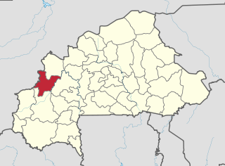
Yatenga is one of the provinces of Burkina Faso, located in the Nord Region of the country. In modern Yatenga, the most prominent city is Ouahigouya. This city served as the capital of the kingdom of Yatenga, a powerful kingdom out of the many Mossi kingdoms, but its influence decreased in the century following French colonisation. The city is famed today for being home to the Naba's compound and the tomb of Naba Kango.
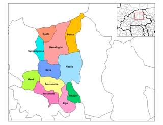
Bam is one of the 45 provinces of Burkina Faso. It is located in Centre-Nord Region and the capital of Bam is Kongoussi. In 2019 it has a population of 473,955. It is a rural province with 420,314 of its residents living in the countryside; only 53,641 live in urban areas. There are 229,786 men living in Bam Province and 244,169 women.
Banwa is one of the 45 provinces of Burkina Faso and is in Boucle du Mouhoun Region. The capital of Banwa is Solenzo. In 2019 it had a population of 345,749.

Bazèga is one of the 45 provinces of Burkina Faso and is in Centre-Sud Region. The capital of Bazèga is Kombissiri. Bazèga had a population of 238,202 in 2006 and in 2011 it was estimated to be 263,603.

Kouritenga is one of the 45 provinces of Burkina Faso, located in its Centre-Est Region. In 2019, the province had a population of 479,930. Its capital is Koupéla.

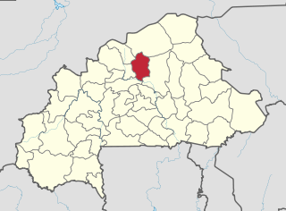
Namentenga is one of the 45 provinces of Burkina Faso, located in its Centre-Nord Region.

Bourzanga is a department of Bam Province in northern-central Burkina Faso. Its capital lies at Bourzanga town. According to the 2019 census the commune has a population of 103,266.

Bana is a department or commune of Balé Province in southern Burkina Faso. Its capital lies at the town of Bana. According to the 2019 census the department has a population of 19,787.
Pompoï is a department or commune of Balé Province in southern Burkina Faso. Its capital lies at the town of Pompoï. According to the 2019 census the commune has a total population of 14,067.
Guibare is a department or commune of Bam Province in north-western Burkina Faso. Its capital lies at the town of Guibare. According to the 1996 census the department has a total population of 22,510.

Kongoussi is a department or commune of Bam Province in north-western Burkina Faso. Its capital is the town of Kongoussi. According to the 2019 census the department has a total population of 121,585.
Rouko is a department or commune of Bam Province in north-western Burkina Faso. Its capital lies at the town of Rouko. According to the 1996 census the department has a total population of 13,175.
Tikare is a department or commune of Bam Province in north-western Burkina Faso. Its capital lies at the town of Tikare. According to the 2019 census the department has a total population of 52,263.

Sami is a department or commune of Banwa Province in western Burkina Faso. Its capital lies at the town of Sami. According to the 2019 census the department has a total population of 13,596.

Coalla is a department or commune of Gnagna Province in northern Burkina Faso. Its capital lies at the town of Coalla. It has an area of 1,957 km2.

Gossina is a department or commune of Nayala Province in western Burkina Faso. Its capital lies at the town of Gossina. According to the 1996 census the department has a total population of 17,945. In reference to the 2019 census, the population had seen a surge and was 26, 241. The male were 12,606 while the women were 13, 635.
Dablo is a department or commune of Sanmatenga Province in central Burkina Faso. Its capital lies at the town of Dablo.
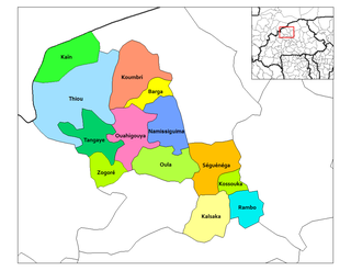
Kalsaka is a department or commune of Yatenga Province in northern Burkina Faso. Its capital lies at the town of Kalsaka.
Séguénéga is a department or commune of Yatenga Province in northern Burkina Faso. Its capital lies at the town of Ouahigouya.
Zogoré is a department or commune of Yatenga Province in northern Burkina Faso. Its capital lies at the town of Zogoré.

