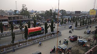
Rajbiraj is a mid-sized municipality located in the south-eastern part of Madhesh Province of Nepal. The city is also called the "Pink City of Nepal" because the township was designed in 1938 based on influence from the "Indian Pink City" Jaipur - thus making it the first township in Nepal to receive urban planning. Rajbiraj is the district headquarters of Saptari which is transferred from old district headquarter Hanumannagar in 1944 and is the eighth largest city in the province. It was declared a municipality in 1959. According to the 2021 census, the city had a population of 70,803 making it the 77rh largest municipality in Nepal. The city area is spread over 55.64 km2 (21.48 sq mi) and comprises 16 wards.

Khotang District is one of 14 districts of Koshi Province of eastern Nepal. The district, with Diktel as its district headquarters, covers an area of 1,591 km2 (614 sq mi) and has a population (2021) of 206,312. The district is bordered by Bhojpur District in the east, Udayapur District in the south, Okhaldhunga District in the west and Solukhumbu District in the North. In this district there are two municipalities and eight rural/urban municipalities.

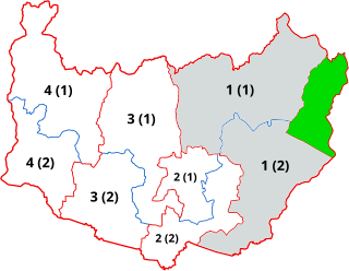
Saptari, a part of Madhesh Province, is one of the seventy-seven districts of Nepal. Its district headquarter is Rajbiraj. Saptari is an Outer Terai district. This district covers an area of 1,363 km2 (526 sq mi) and has a population (2011) of 639,284 which makes it the 10th most populated district of Nepal. Saptari is renowned for its agricultural output, and is bordered on the east by the massive Sapta Koshi river.
Siraha District, a district in Madhesh Province, is one of the seventy-seven districts of Nepal. It is situated in the Terai belt of Nepal. The district, with Siraha as its district headquarters, covers an area of 1,188 km2 (459 sq mi). It has population of 637,328 according to census of 2011.The District is bordered with Saptari district in the east, Udayapur districting the north, Bihar state of India in the south and Dhanusa district in the west. Majority of the population here is Kushwaha(Mahato/Singh), Yadav, Tharus, Sahs(sahukar), Muslims and ethnic minorities with majority population speaking Maithili language and Nepali language.

Triyuga is one of the eight municipalities of Udayapur district of the Koshi Pradesh of Nepal. Gaighat is the headquarter of the municipality. According to the 2021 Nepal census the total population of the municipality is 103,475. It is divided into 16 wards. Triyuga Municipality was established on B.S. Chaitra 13, 2053. It was named after Triyuga River. A river which flows through the town. Triyuga is the 3rd largest municipality in Nepal and 1st largest in Koshi Pradesh in term of size (area). The total area of the municipality is 547.43 square kilometres (211.36 sq mi)

Nijgadh, is a town and municipality in Nepal, located in Bara District of the Madhesh Province. The total area of the municipality is 289.4 sq. km. The municipality was formed on 8 May 2014 by merging Nijgadh VDC with Ratnapuri VDC and Bharatganj Singaul VDC.
Bhardaha is a local town of Hanumannagar Kankalini Municipality in Saptari District of Madhesh Province in Nepal. At the time of the 2022 Nepal census it had a population of 14,564 people living in 7,239 individual households.
Hanumannagar is a village development committee in Saptari District in the Sagarmatha Zone of south-eastern Nepal. It is named after the Hanuman Temple situated here with the rare idol of Lord Hanuman in Black Stone as a Child. It was the former headquarter of Saptari District. It was established by Rana Rulers after continuous flooding in Bihar. Rich merchants from Bihar's then Bhagalpur District were invited to stay and trade in Nepal. On his invite lot of Marwari and Deshwali Merchants come to the place. Accordingly Hanumannagar was made District and Anchal Headquarters. The city started thriving on trade between India and Tibet and at one point in time it was the second biggest town in Eastern Nepal. Even Ram Manohar Lohia stayed in Hanuman Nagar when he was hiding from British Rulers of India.
Malhaniya is a village development committee in Saptari District in the Sagarmatha Zone of south-eastern Nepal. At the time of the 2011 Nepal census it had a population of 7,820 people living in 1,558 individual households.

Kankalini Temple is a temple and Shakti Peethas in Eastern Nepal in Bhardaha VDC, Saptari, 19 km east of district headquarter Rajbiraj and near the Indian border at Birpur. It draws Nepali and Indian pilgrims, especially during Dashain when thousands of goats and Rangaa sacrificed there. The temple is near Mahendra Highway Bhardah section. It is famous temple of bhardaha.

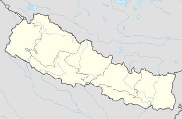
A municipality in Nepal is an administrative division in the Provinces of Nepal. The urban population of Nepal refers to the inhabitants residing in the designated municipal area. Population size has been taken as the principal criteria in the declaration of urban areas in Nepal since 1961. Municipalities can therefore also include rural areas. It functions as a sub-unit of a district. Nepal currently has 293 municipalities, which given the 2011 population estimate of 16,656,057.
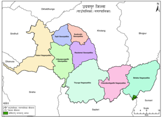
Belaka is a municipality located in Udayapur District of Province No. 1 of Nepal. It is one of four urban municipalities located in Udayapur District.
Hanumannagar Kankalini is a municipality of Saptari District in Sagarmatha Zone of eastern Nepal. The municipality was established on 19 September 2015 by merging the existing Hanuman Nagar, Joginiya-1, Joginiya-2, Gobargada and Inarwa village development committees (VDCs). Later, Bhardaha, Portaha, Madhawapur, Rampur Malhniya, Malhniya village development committees (VDCs) were added to the existing Hanumannagar Yoginimai Municipality.

Dakneshwori Municipality is located in Saptari District in Madhesh Province of Nepal. It was formed in 2016 occupying current 10 sections (wards) merging previous Kabilasha, Hariraha, Tarhi, Bhuthi, Pato, Aurahi, Brahampur, Gamahariya Parwaha, Patthargada and Banaula VDCs. It occupies an area of 69.11 km2 with a total population of 44,782. Dakneshwori Municipality is named after the famous temple Dakneshwori Bhagwati located at ward no. 5, Pato.
Saptakoshi Municipality is located in Saptari District in the Province 2 of Nepal. It was formed in 2014 and then again modified in 2016 occupying current 11 sections (wards) from previous 11 wards. It occupies an area of 60.25 km2 (23.26 sq mi) with a total population of 21,139.
Balan-Bihul is a rural municipality in Saptari District in Province No. 2 of south-eastern Nepal. At the time of the 2017 Nepal census it had a population of 26,068 people living in 6,560 individual households. There are six village development committees (wards) malhaniya, ., mauwha, sehra, madirwala tol etc. lies under this gaupalika. )

The Janamat Party is a Nepalese political party. The party stands as a national party in Nepal and is the eighth-largest party since the 2022 general election.
The People's Socialist Party, Nepal, also known as Janata Samajbadi Party Nepal is the eighth largest political party in Nepal. Since the 2022 local election, the party has been limited to stand only as the third largest party of Madhesh Province after the Nepali Congress and CPN (UML) respectively.
Saptari 1 is one of four parliamentary constituencies of Saptari District in Nepal. This constituency came into existence on the Constituency Delimitation Commission (CDC) report submitted on 31 August 2017.

Nawal Kishor Sah Sudi is a Nepalese politician who currently serves as the Minister for Women, Children, and Senior Citizens in Nepal. He is a member of the Janata Samajwadi Party and was appointed to this position in July 2024. He previously served as the Minister for Forests and Environment, where he was involved in environmental protection initiatives.