
Belize is a country on the north-eastern coast of Central America. It is bordered by Mexico to the north, the Caribbean Sea to the east, and Guatemala to the west and south. It also shares a water boundary with Honduras to the southeast.

Demographics of the population of Belize include population density, ethnicity, education level, health of the populace, economic status, religious affiliations and other aspects.

Dangriga, formerly known as Stann Creek Town, is a town in southern Belize, located on the Caribbean coast at the mouth of the North Stann Creek River. It is the capital of Belize's Stann Creek District. Dangriga is served by the Dangriga Airport. Commonly known as the "culture capital of Belize" due to its influence on punta music and other forms of Garifuna culture, Dangriga is the largest settlement in southern Belize.

Stann Creek District is a district in the south east region of Belize. According to the 2010 census, the district had a population of 32,166 people. Its capital is the town of Dangriga, formerly known as "Stann Creek Town." Stann comes from "stanns," or safe havens used by colonialists coming from the "old world" to the "new world."

Toledo District is the southernmost and least populated district in Belize. Punta Gorda is the District capital. According to the Human Development Index (HDI), it is the second most developed region in the country. The district has a diverse topography which features rainforests, extensive cave networks, coastal lowland plains, and offshore cays. Toledo is home to a wide range of cultures such as Mopan, Kekchi Maya, Creole, Garifuna, East Indians, Mennonites, Mestizos, and descendants of US Confederate settlers.
Belize District is a district of the nation of Belize. Its capital is Belize City.
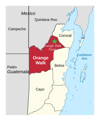
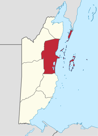
Orange Walk District is a district in the northwest of the nation of Belize, with its district capital in Orange Walk Town.
Guinea Grass is a village in the Orange Walk District of the nation of Belize. It is 38 metres above sea level. According to the 2000 census, Guinea Grass had a population of 2,510 people; by 2010 the census figures showed a population of 3,500. The population is made up of mostly Mestizos, Creoles, and East Indians. There are a number of Mennonites, Taiwanese and other Central American immigrants living near or immediately in the village.
Monkey River Town is a village in the north of the Toledo District of Belize. It is on the Caribbean Sea on the southern shore of the mouth of Belize's Monkey River. In 2011 the estimated population was 200 people.
Mullins River is the name of both a river and of a village on that river in the Stann Creek District of Belize.

Placencia is a small village located in the Stann Creek District of Belize.

Gales Point Manatee is a village in Belize District in the nation of Belize, Central America. The village is bordered by five other communities namely Mullins River ,St. Margaret,La Democracia,Gracie Rock and Freetown Sibun.The village is bordered east by the Caribbean Sea. In 2000, Gales Point had a population of about 500 people, most of whom subsist on fishing and farming.
Belizean Creoles, also known as Kriols, are a Creole ethnic group native to Belize.
Chalsa is a census town in the Matiali CD block in the Malbazar subdivision of the Jalpaiguri district in West Bengal, India.
Gardenia is a village in Belize District, Belize located about 20 miles (32 km) north of Belize City.
Nagrakata is a village in the Nagrakata community development block in the Malbazar subdivision of the Jalpaiguri district, West Bengal.National Highway 17 passes through Nagrakata. It is a station on the New Jalpaiguri-Alipurduar-Samuktala Road Line.
La Democracia is a populated settlement located in the nation of Belize. It is a mainland village that is located in Belize District.

Santa Cruz is a village in Stann Creek District, Belize. It is located 24 miles northwest of the Placencia peninsula.
Batabari Tea Garden is a village and a gram panchayat in the Matiali CD block in the Malbazar subdivision of the Jalpaiguri district in the state of West Bengal, India.
Maya Center is a village in the Stann Creek District of Belize. It is located on the road to the Cockscomb Basin Wildlife Sanctuary. According to the 2010 census, Maya Center has a population of 386 people in 87 households.