
Arunachal Pradesh is a state in Northeastern India. It was formed from the erstwhile North-East Frontier Agency (NEFA) region, and became a state on 20 February 1987. Itanagar is the state capital.

The Brahmaputra is a trans-boundary river which flows through Tibet, Northeastern India, and Bangladesh. It is also known as the Yarlung Tsangpo in Tibetan, the Siang/Dihang River in Arunachali, Luit and Brahmaputra in Assamese, Brahmaputro in Bengali in India and Jamuna River in Bangla in Bangladesh. It is the 9th largest river in the world by discharge, and the 15th longest.

Ziro is a town in and the district headquarters of the Lower Subansiri district in the Indian state of Arunachal Pradesh. It is included the Tentative List for UNESCO's World Heritage Site for the Apatani cultural landscape. The part of the town which is the centre of economic activities and where the administrative offices are located is called as Hapoli or locally known by the Apatanis as "Hao-Polyang".

Lower Subansiri district (Pron:/su:bənˈsɪɹi/) is one of the 25 administrative districts of the state of Arunachal Pradesh in northeastern India.

Lakhimpur district is an administrative district in the state of Assam in India. The district headquarter is located at North Lakhimpur. The district is bounded on the North by Siang and Papumpare districts of Arunachal Pradesh and on the East by Dhemaji District and Subansiri River. Majuli District stands on the Southern side and Biswanath District is on the West.
Tani, is a branch of Sino-Tibetan languages spoken mostly in Arunachal Pradesh, Assam, and neighboring regions.
Dhemaji is a City in Assam and it is the headquarters of Dhemaji district, Assam, India.

The North-East Frontier Agency (NEFA), originally known as the North-East Frontier Tracts (NEFT), was one of the political divisions in British India, and later the Republic of India until 20 January 1972, when it became the Union Territory of Arunachal Pradesh and some parts of Assam. Its administrative headquarters was Shillong. It received the status of State on 20 February 1987.
Miri or Mising, also known as Plains Miri, is a Tani language spoken by the Mising people. There are 629,954 speakers, who inhabit mostly the Lakhimpur, Sonitpur, Dhemaji, Dibrugarh, Sibsagar, Jorhat, Majuli, Golaghat, Tinsukia districts of Assam and also some parts of Arunachal Pradesh. The primary literary body of Mising is known as 'Mising Agom Kébang '.

Upper Assam is an administrative division of the state of Assam comprising the undivided Lakhimpur and Sivasagar districts, of the upper reaches of the Brahmaputra valley. The other divisions are: Lower Assam, North Assam and Hills and Barak Valley. The division is under the jurisdiction of a Commissioner, stationed at Jorhat.
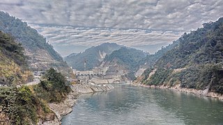
The Subansiri Lower Dam, officially named Subansiri Lower Hydroelectric Project (SLHEP), is an under construction gravity dam on the Subansiri River in North Eastern India. It is located 2.3 km (1.4 mi) upstream of Subansiri River on Arunachal Pradesh. Described as a run-of-the-river project by NHPC Limited, the Project is expected to supply 2,000 MW of power when completed. The project has experienced several problems during construction to include landslides, re-design and opposition. It was expected to be complete in 2018. It is notable that, if completed as planned, it will be the largest hydroelectric project in India.

The Subansiri River is a trans-Himalayan river and a tributary of the Brahmaputra River that flows through Tibet's Lhuntse County in the Shannan Prefecture, and the Indian states of Arunachal Pradesh and Assam. The Subansiri is 442 kilometres (275 mi) long, with a drainage basin 32,640 square kilometres (12,600 sq mi). It is the largest tributary of the Brahmaputra contributing 7.92% of the Brahmaputra's total flow.
Nyishi is a Sino-Tibetan language of the Tani branch spoken in Papum Pare, Lower Subansiri, Kurung Kumey, Kra Daadi, East Kameng, Pakke Kesang, Kamle districts of Arunachal Pradesh and Darrang District of Assam in India. According to the 2011 census of India, the population of the Nishi speakers is approximately 900,000. Though there are plenty of variations across regions, the dialects of Nishi, such as Akang, Aya, Nyishi (raga), Mishing, Tagin are easily mutually intelligible, with the exception of the rather small in population Bangni-Bangru and Solung Dialects being very different from the former. 'Nisi' is sometimes used as a cover term for western Tani languages.
The Rangiya-Murkongselek section is a 450 km (280 mi) long railway line connecting Rangiya in Kamrup district with Murkongselek in Dhemaji district in the Indian state of Assam. The entire section is under the jurisdiction of Northeast Frontier Railway.

The following outline is provided as an overview of and topical guide to Arunachal Pradesh:

Havildar Hangpan Dada, AC was a soldier in the Assam Regiment of the Indian Army. He was posthumously awarded the Ashoka Chakra, India's highest peacetime military decoration in August 2016.
Kamle district, also Khamle, is one of the 25 administrative districts of Arunachal Pradesh in northeastern India. The district headquarters are at Raga.

The Dikrong River is a sub-tributary of the Brahmaputra River in the Indian state of Assam. The Dikrong river originates in the hills of Arunachal Pradesh and flows through major cities like Nirjuli in Arunachal Pradesh and Bihpuria in Assam before its confluence with the Subansiri River.

Gelemo or Gelomo (full name: Gelomoring) is a border village in the Upper Subansiri district, Arunachal Pradesh, India. It is on the bank of the Tsari Chu river before its confluence with the Subansiri River, at a distance of "two days march" from the Indian claimed border at Longju. The present Line of Actual Control between China and India is at roughly half that distance.


