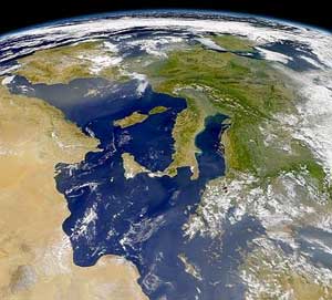
Italy is located in southern Europe and comprises the long, boot-shaped Italian Peninsula, the southern side of Alps, the large plain of the Po Valley and some islands including Sicily and Sardinia. Corsica, although belonging to the Italian geographical region, has been a part of France since 1769. Italy is part of the Northern Hemisphere.

The Arctic Archipelago, also known as the Canadian Arctic Archipelago, is a group of islands north of the Canadian mainland.
Troitsk is the name of several inhabited localities in Russia.
Hrabyně is a village in the Moravian-Silesian Region of the Czech Republic, approx. 20 km north-west from Ostrava and 13 km south-east from Opava. It consists of two parts, Hrabyně and Josefovice, which have cca 1,200 inhabitants altogether.

Daszewo is a village in Poland. It is located in Białogard County, West Pomeranian Voivodeship in northwestern Poland.
Smolec is a village in the administrative district of Gmina Kąty Wrocławskie, within Wrocław County, Lower Silesian Voivodeship, in south-western Poland. Prior to 1945 it was Schmolz, Germany.
Abus Valley is an ice-free valley 3 miles (5 km) southeast of Turnstile Ridge at the north end of Britannia Range. Named in association with Britannia by a University of Waikato geological party, 1978–79, led by Michael Selby. Abus was the name of the River Humber during the Roman period.

Priboieni is a commune in Argeș County, in southern central Romania. It is composed of eight villages: Albotele, Paraschivești, Priboieni, Sămăila, Pitoi, Valea Mare, Valea Nenii and Valea Popii.
Gorban is a commune in Iași County, Romania. It is composed of five villages: Gorban, Gura Bohotin, Podu Hagiului, Scoposeni and Zberoaia.

Adzhily is a village in the Imishli Rayon of Azerbaijan.
Gariban is a village in the Khizi Rayon of Azerbaijan.
Bistuszowa is a village in the administrative district of Gmina Ryglice, within Tarnów County, Lesser Poland Voivodeship, in southern Poland. It lies approximately four miles west of Ryglice, 18 km (11 mi) south of Tarnów, and 85 km (53 mi) east of the regional capital Kraków.
Zapałów is a village in the administrative district of Gmina Wiązownica, within Jarosław County, Subcarpathian Voivodeship, in south-eastern Poland. It lies approximately 17 kilometres (11 mi) north-east of Jarosław and 64 km (40 mi) east of the regional capital Rzeszów.
Oględa is a village in the administrative district of Gmina Przasnysz, within Przasnysz County, Masovian Voivodeship, in east-central Poland. It lies approximately 8 kilometres (5 mi) north of Przasnysz and 97 km (60 mi) north of Warsaw.
Brudnice is a village in the administrative district of Gmina Żuromin, within Żuromin County, Masovian Voivodeship, in east-central Poland. It lies approximately 3 kilometres (2 mi) north-west of Żuromin and 123 km (76 mi) north-west of Warsaw.

Janowice is a village in the administrative district of Gmina Bestwina, within Bielsko County, Silesian Voivodeship, in southern Poland. It lies approximately 3 kilometres (2 mi) south-east of Bestwina, 6 km (4 mi) north of Bielsko-Biała, and 42 km (26 mi) south of the regional capital Katowice.
Czarny Las is a village in the administrative district of Gmina Mykanów, within Częstochowa County, Silesian Voivodeship, in southern Poland. It lies approximately 10 kilometres (6 mi) north of Częstochowa and 71 km (44 mi) north of the regional capital Katowice.
Pieczonki is a village in the administrative district of Gmina Giżycko, within Giżycko County, Warmian-Masurian Voivodeship, in northern Poland. It lies approximately 10 kilometres (6 mi) north-east of Giżycko and 97 km (60 mi) east of the regional capital Olsztyn.
Zelki is a village in the administrative district of Gmina Wydminy, within Giżycko County, Warmian-Masurian Voivodeship, in northern Poland. It lies approximately 12 kilometres (7 mi) south of Wydminy, 28 km (17 mi) south-east of Giżycko, and 105 km (65 mi) east of the regional capital Olsztyn.
Kukań is a village in the administrative district of Gmina Gryfice, within Gryfice County, West Pomeranian Voivodeship, in north-western Poland. It lies approximately 9 kilometres (6 mi) south-west of Gryfice and 62 km (39 mi) north-east of the regional capital Szczecin.

