Sivasagar is a town and headquarter of the Sivasagar district, Assam. Sivasagar is situated about 360 kilometers (224 mi) northeast of Guwahati. It is well known for its Ahom palaces and monuments. Sivasagar is an important centre for tea and oil industries today.
Sivasagar district, formerly known as Sibsagar, is one of the 34 districts of Assam state in Northeast India. Sivasagar city is the administrative headquarters of this district. This historic place is also known for its rich biodiversity. The districts covers an area of 2668 square kilometers. The district comprises two sub-divisions – Sivasagar and Nazira. The district of Sivasagar lies between 26.45°N and 27.15°N latitudes and 94.25°E and 95.25°E longitudes. The district is bounded by the Brahmaputra River to the north, Nagaland to the south, the Charaideo district to the east and the Jhanji River to the west. The Sivasagar district has acquired its distinct identity due to the co-existence of different races, tribes, languages and cultures.

The Moamoria rebellion (1769–1805) was an 18th-century uprising in Ahom kingdom of present-day Assam that began as power struggle between the Moamorias (Mataks), the adherents of the Mayamara Sattra, and the Ahom kings. This uprising spread widely to other sections of Ahom kingdom including disgruntled elements of the Ahom aristocracy leading to two periods in which the Ahom king lost control of the capital. Retaking the capital was accompanied by a massacre of subjects, leading to a steep depopulation of large tracts. The Ahom king failed to retake the entire kingdom; a portion in the north-east, Bengmara, became known as Matak Rajya ruled by a newly created office called Borsenapati, became a tribute-paying but virtually independent territory.

Susenghphaa or Pratap Singha, was the 17th and one of the most prominent kings of the Ahom kingdom. As he was advanced in years when he became king, he is also called the burha Raja. His reign saw an expansion of the Ahom kingdom to the west, the beginning of the Ahom-Mughal conflicts, and a reorganization of the kingdom with an expanded Paik system and reoriented village economy designed by Momai Tamuli Borbarua. His expansion to the west is underlined by the two new offices that he created: that of the Borbarua and the Borphukan. The alliances he formed with the rulers of Koch Hajo resulted in formation that successfully thwarted Mughal expansion. The administrative structure that he created survived until the end of the Ahom kingdom in 1826.

The Ahom kingdom or the Kingdom of Assam was a late medieval kingdom in the Brahmaputra Valley that retained its independence for nearly 600 years despite encountering Mughal expansion in Northeast India. Established by Sukaphaa, a Tai prince from Mong Mao, it began as a mong in the upper reaches of the Brahmaputra based on wet rice agriculture. It expanded suddenly under Suhungmung in the 16th century and became multi-ethnic in character, casting a profound effect on the political and social life of the entire Brahmaputra valley. The kingdom became weaker with the rise of the Moamoria rebellion, and subsequently fell to repeated Burmese invasions of Assam. With the defeat of the Burmese after the First Anglo-Burmese War and the Treaty of Yandabo in 1826, control of the kingdom passed into East India Company hands.
Choapha Supatpha also Swargadeo Gadadhar Singha, was the twenty-ninth king of Ahom kingdom, who reigned from 1681 to 1696. He established the rule of Tungkhungia royal house of Ahom kings, whose descendants continued to rule till the climactic end of the Ahom kingdom in 1826. He was earlier known as Gadapani Konwar and was a son of Gobar raja, a descendant of Suhungmung, and who had become king for twenty days. Gadadhar Singha stabilized the Ahom kingdom, which was going through a long decade of political turmoil and instability. This period saw the ruthless power grab of Debera Borbarua and Laluksola Borphukan's abandonment of Guwahati to the hands of Mughals and oppression via Sulikphaa alias Lora Roja.

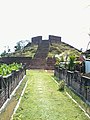
Garhgaon is a historic town in Assam, India and served as the capital of the Ahom kingdom for many years. It was built by the Ahom king Suklenmung in 1540. It lies 13 km east of present-day Sivasagar town, headquarters of the Sivasagar district. The palace structures were made of stone and wood. In 1747 Pramatta Singha, son of Rudra Singha, constructed a brick wall of about 5 km in length surrounding the Garhgaon palace and the masonry gate leading to it.
Joymoti Konwari was the wife of Ahom prince Gadapani. She died at the hands of the royalists under Sulikphaa Loraa Roja without disclosing her exiled husband Gadapani's whereabouts in the Naga Hills, thereby enabling her husband to rise in revolt and assume kingship.

Sukhrungphaa or Swargadeo Rudra Singha was the 30th Ahom king, reigning from 1696 to 1714 A.D. His father Gadadhar Singha freed Assam from the Mughal disturbances and internal conspiracies, thereby Rudra Singha inherited a stable state and government and had the advantage of the solid foundations laid by his father. He devoted his time to transform Assam into a first-rate power in India. He stopped the persecution of the Neo-Vaisnava sect and built temples, several public works, and patronized art, literature, and culture. Rudra Singha is also famed for being the real father of Ahom architecture. He giving up the isolationist policy of his predecessors forged diplomatic ties with various states of that time and established extensive trade with Bengal.
Suremphaa, or Rajeswar Singha, the fourth son of Rudra Singha, became the king of the Ahom kingdom after the death of his brother King Pramatta Singha. Rudra Singha's third son, Mohanmala Gohain, was considered ineligible for kingship as his face was pitted with smallpox marks. According to the norm established after Sulikphaa Lora Roja, an Ahom prince had to be free from any physical disability, defects or deformities to become a king.

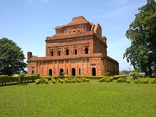
Sunenphaa also, Pramatta Singha, was the king of Ahom Kingdom. He succeeded his elder brother Swargadeo Siva Singha, as the king of Ahom Kingdom. His reign of seven years was peaceful and prosperous. He constructed numerous buildings and temples. The most famous of his buildings was the Rang Ghar, which is also considered as the oldest amphitheatre in Asia.

Sutanphaa also Siva Singha was the 31st king of Assam from the Ahom dynasty who reigned from He was the eldest son of King Rudra Singha. Siva Singha was with his dying father at Guwahati, who then proceeded to the capital Rangpur where he ascended to the throne. He is noted for his elaborate system of espionage. He had numerous temples erected and made large gifts of land to them. With his patronage, Hinduism became the pre-dominant religion of the Ahoms. The king was also a patron of music and literature and music and himself composed Sanskrit songs and learnt songs. His reign coincided with the arrival of the first Europeans traders into Assam.

The Rang Ghar, is a two-storeyed building which once served as the royal sports-pavilion where Ahom kings and nobles were spectators at games like buffalo fights and other sports at Rupahi Pathar - particularly during the Rongali Bihu festival in the Ahom capital of Rangpur.

Sunyeopha also Lakshmi Singha, was the 34th Ahom king, who reigned from 1769 to 1780. After the death of Suremphaa, he married the Queen Kuranganayani and became the king of the Ahom kingdom. Shortly after he was installed he became a captive of the rebels of the Moamoria rebellion for a few months but soon managed to regain his kingdom. With the help of Kuranganayani, after destroying all the Moamoria rebels including Borbaruah Ragho, Lakshmi Singha was once again crowned as king of Ahom kingdom.

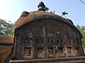
The Talatal Ghar ) is an 18th-century palace and military base located in Rangpur, 4 kilometres (2.5 mi) from present-day Sivasagar, Assam, India. It is the largest of the monument built during the Ahom era. King Rudra Singha was responsible for the construction of Kareng Ghar, but the present structure was built by king Rajeswar Singha (Surempha). It was initially built as an army base. It had 2 tunnels and 3 underground floors. Currently this structure is in dilapidated condition, the present ruins betray the grandeur that the palace was once endowed with.
Kareng, also known as The Garhgaon Palace, is located in Garhgaon 15 kilometres (9.3 mi) from Sivasagar, Assam, India. The palace structures were made of wood and stone. In 1751 Sunenphaa, son of Sukhrungphaa, constructed the brick wall of about 5 kilometres (3.1 mi) in length surrounding the Garhgaon Palace and the masonry gate leading to it.
The Gola Ghar is a historical monument located in Joysagar, 4 km from Sivasagar, Assam. It is an ammunition store house used by the Ahoms and is situated near the Talatal Ghar. The Gola Ghar was built during the reign of Chakradhwaj Singha.

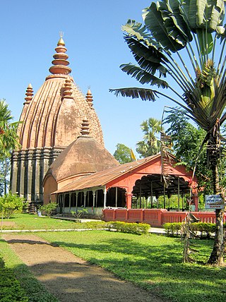
The Keshavnarayan Vishnu dol, popularly known as Joy dol, was constructed in 1698 by Ahom king Swargadeo Rudra Singha (1696–1714) in honour and memory of his mother Joymoti. Particularly this temple is dedicated to Hindu god Lord Vishnu. The presiding deity of the temple was before known as Kesavaraya Visnu This temple is constructed of brick and stone. The walls are decorated with images of celestial beings and sculptures representing the social life of the day such as the sports and favourite pastimes of the erstwhile Ahom kings. The Joysagar Group of temples standing on the banks of the tank of the same name includes the Joydol, the Sivadol, the Devi Ghar, and the Ghanashyam House.

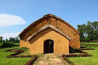
Ghanashyam House or Nati Gosain dol is an early 18th-century brick monument built during the reign of the king Rudra Singha dedicated to the architect Ghanashyam. This monument is situated on the west bank of Joysagar Tank. It is 4 km away from Sivasagar town towards west.
Baduli Borphukan, also known as Baduli Roja Sahur was a loyal administrative officer in the Ahom Kingdom, serving during the reign of Ahom king Jayadhwaj Singha. He was also the brother of Momai Tamuli Borbarua, a prominent minister in the Ahom kingdom. As a Borphukan, Baduli Roja Sahur played a crucial role in the Ahom Kingdom's defense against the Mughal Empire. He fought valiantly against the Mughal Subahdar (governor) Mir Jumla, who led a campaign against the Ahom Kingdom in the 17th century. Additionally, he played a key role in developing the kingdom's infrastructure, constructing the Seuni Ali road from Jorhat to the capital city Garhgaon. This road facilitated communication, and military movements, showcasing his vision and leadership. Baduli Borphukan's legacy continued through his son, Baduli Dekaphukan and grandson Maupia Phukan.