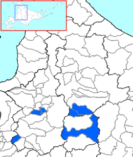
Sorachi is a district divided between Sorachi and Kamikawa Subprefectures, Hokkaido, Japan. As of 2004, the district has an estimated population of 53,011 and an area of 1,497.21 km², giving a population density of 35.41 persons per square kilometer.
Girovaris is an island of the Echinades, among the Ionian Islands group of Greece. As of 2011, it had no resident population. Administratively, it is part of the municipal unit Pylaros.

Kliszkowice is a village in the administrative district of Gmina Żmigród, within Trzebnica County, Lower Silesian Voivodeship, in south-western Poland. Prior to 1945 it was in Germany.

Hendricks County Airport, also known as Gordon Graham Field, is a public airport at 2749 Gordon Graham Blvd. in Danville, a town in Hendricks County, Indiana, United States. Owned by the Indianapolis Airport Authority, it is located 13 miles (21 km) west of the central business district of Indianapolis and serves as a reliever airport for Indianapolis International Airport. The airport is also two miles (3 km) southeast from the center of Danville.
The Psefir River is a river in Krasnodar Krai, Russia, which flows into the Kuban River. The area around the river is populated by various Abadzekh and Circassian tribes. The stanitsa of Kostromskaya stands on the river.

Argavand is a village in the Ararat province of Armenia. It has been absorbed by modern-day Yerevan and is within the city limits. Located in the village is a Turkmen funerary monument built in 1413.

Sela Subregion is a subregion in the northwestern Anseba region of Eritrea. Its capital lies at Sela.

Certers is a village in Andorra, located in the parish of Sant Julià de Lòria.
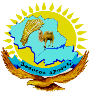
Denisov is a district of Kostanay Region in northern Kazakhstan. The administrative center of the district is the settlement of Denisovka. Population: 20,646 ; 21,912 ; 29,333.
Noragavit or Noragavit’, is a neighbourhood within the Shengavit District of Yerevan, Armenia.
Pawłowice is a village in the administrative district of Gmina Krzyżanów, within Kutno County, Łódź Voivodeship, in central parts of Poland. It lies approximately 3 kilometres (2 mi) south-east of Krzyżanów, 11 km (7 mi) south-east of Kutno, and 44 km (27 mi) north of the regional capital Łódź.
Zabłocie is a village in the administrative district of Gmina Sadkowice, within Rawa County, Łódź Voivodeship, in central Poland. It lies approximately 5 kilometres (3 mi) south-west of Sadkowice, 18 km (11 mi) south-east of Rawa Mazowiecka, and 71 km (44 mi) east of the regional capital Łódź.
Janowo Racięckie is a village in the administrative district of Gmina Wierzbinek, within Konin County, Greater Poland Voivodeship, in west-central Poland.
Orsy is a village in the administrative district of Gmina Górowo Iławeckie, within Bartoszyce County, Warmian-Masurian Voivodeship, in northern Poland, close to the border with the Kaliningrad Oblast of Russia. It lies approximately 10 kilometres (6 mi) north of Górowo Iławeckie, 24 km (15 mi) north-west of Bartoszyce, and 64 km (40 mi) north of the regional capital Olsztyn.

Khasala Kalan is a village of Rawalpindi District in the Punjab province of Pakistan. It is located at 33°26'24N 72°58'25E with an altitude of 370 meters (1217 ft) and lies south of the Rawalpindi on Adyala Road and approximately about 6 km meter ahead from adyala jail. A significant proportion of the population belong to the Araien And Rajput Families. In the Middle of Village A Tomb Of PIR QAZI ZAREEN BAIG SAHIB, A small DAM is Located Behind The Village Khasala Kalan, Very beautiful location and visiting and picnic spot.
Guelaat Bou Sbaa is a town and commune in Guelma Province, Algeria.
Lõpi is a village in Saaremaa Parish, Saare County in western Estonia.

Hamples Corner is an unincorporated community in the town of Center, Outagamie County, Wisconsin, United States.
Kowŏn Station is a railway station of the Korean State Railway in Kowŏn-ŭp, Kowŏn County, South Hamgyŏng, North Korea. It is the junction where the P'yŏngra Line, which connects P'yŏngyang to Rajin, meets the Kangwŏn Line running from Kowŏn to P'yŏnggang.
Nur Mohammad Kandi-ye Vosta is a village in Aslan Duz Rural District, Aslan Duz District, Parsabad County, Ardabil Province, Iran. At the 2006 census, its population was 325, in 57 families.


