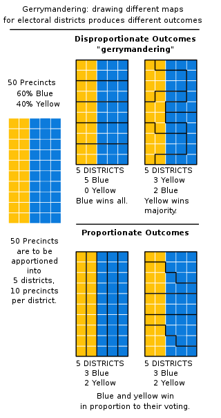
In representative democracies, gerrymandering is the political manipulation of electoral district boundaries with the intent to create undue advantage for a party, group, or socioeconomic class within the constituency. The manipulation may involve "cracking" or "packing". Gerrymandering can also be used to protect incumbents. Wayne Dawkins describes it as politicians picking their voters instead of voters picking their politicians.

Punjab is a geopolitical, cultural, and historical region in South Asia. It is specifically located in the northern part of the Indian subcontinent, comprising areas of modern-day eastern-Pakistan and northwestern-India. Punjab's major cities are Lahore, Faisalabad, Rawalpindi, Gujranwala, Multan, Ludhiana, Amritsar, Sialkot, Chandigarh, Shimla, Jalandhar, Gurugram, and Bahawalpur.
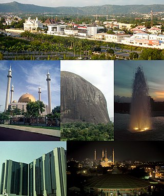
Abuja is the capital and eighth most populous city of Nigeria. Situated at the centre of the country within the Federal Capital Territory (FCT), it is a planned city built mainly in the 1980s based on a master plan by International Planning Associates (IPA), a consortium of three American planning and architecture firms made up of Wallace, Roberts, McHarg & Todd as the lead, Archi systems International, and Planning Research Corporation. The Central Business District of Abuja was designed by Japanese architect Kenzo Tange. It replaced Lagos, the country's most populous city, as the capital on 12 December 1991.

Ho Chi Minh City, commonly known as Saigon, is the most populous city in Vietnam, with a population of around 9.3 million in 2023. Situated in the Southeast region of Vietnam, the city surrounds the Saigon River and covers about 2,061 km2 (796 sq mi).

Postal codes used in the United Kingdom, British Overseas Territories and Crown dependencies are known as postcodes. They are alphanumeric and were adopted nationally between 11 October 1959 and 1974, having been devised by the General Post Office. A full postcode is known as a "postcode unit" and designates an area with several addresses or a single major delivery point.

Washington, D.C., formally the District of Columbia and commonly called Washington or D.C., is the capital city and the federal district of the United States. The city is located on the east bank of the Potomac River, which forms its southwestern border with Virginia and borders Maryland to its north and east. The city was named for George Washington, a Founding Father, victorious commanding general of the Continental Army in the American Revolutionary War, and the first president of the United States who is sometimes referred to as "Father of his country". The district is named for Columbia, the female personification of the nation.

A district is a type of administrative division that in some countries is managed by the local government. Across the world, areas known as "districts" vary greatly in size, spanning regions or counties, several municipalities, subdivisions of municipalities, school district, or political district.

A central business district (CBD) is the commercial and business centre of a city. It contains commercial space and offices, and in larger cities will often be described as a financial district. Geographically, it often coincides with the "city centre" or "downtown". However, these concepts are not necessarily synonymous: many cities have a central business district located away from its commercial and or cultural center and or downtown/city center, and there may be multiple CBDs within a single urban area. The CBD will often be characterized by a high degree of accessibility as well as a large variety and concentration of specialised goods and services compared to other parts of the city. For instance, Midtown Manhattan, New York City, is the largest central business district in the city and in the world. London's city center is usually regarded as encompassing the significantly smaller and historic City of London and the medieval City of Westminster, while the City of London and the transformed Docklands area containing Canary Wharf are regarded as their two respective CBDs. In Chicago, Illinois, the Chicago Loop is the second-largest central business district in the United States. It is also referred to as the core of the city's downtown. Mexico City also has its own historic city center, the colonial-era "Centro Histórico", along with two CBDs: the mid-late 20th century Paseo de la Reforma – Polanco, and the new Santa Fe, respectively. Moscow and Russia's largest central business district is the Moscow International Business Center.

A red-light district or pleasure district is a part of an urban area where a concentration of prostitution and sex-oriented businesses, such as sex shops, strip clubs, and adult theaters, are found. In most cases, red-light districts are particularly associated with female street prostitution, though in some cities, these areas may coincide with spaces of male prostitution and gay venues. Areas in many big cities around the world have acquired an international reputation as red-light districts.

In the United States, a district attorney (DA), county attorney, county prosecutor, state's attorney, prosecuting attorney, commonwealth's attorney, state attorney or solicitor is the chief prosecutor and/or chief law enforcement officer representing a U.S. state in a local government area, typically a county or a group of counties. The exact and scope of the office varies by state. Generally, the prosecutor represents the people of the jurisdiction. With the exception of three states, district attorneys are elected, unlike similar roles in other common law jurisdictions.

Wayanad is a district in the north-east of the Indian state of Kerala, with administrative headquarters at the municipality of Kalpetta. It is the only plateau in Kerala. The Wayanad Plateau forms a continuation of the Mysore Plateau, the southern portion of Deccan Plateau which links the Western Ghats with the Eastern Ghats. It is set high in the Western Ghats with altitudes ranging from 700 to 2100 meters. Vellari Mala, a 2,240 m (7,349 ft) high peak situated on the trijunction of Wayanad, Malappuram, and Kozhikode districts, is the highest point in Wayanad district. The district was formed on 1 November 1980 as the 12th district in Kerala, by carving out areas from Kozhikode and Kannur districts. An area of 885.92 km2 of the district is forested. Wayanad has three municipal towns—Kalpetta, Mananthavady and Sulthan Bathery. There are many indigenous tribes in this area. The Kabini River, a tributary of Kaveri River, originates at Wayanad. Wayanad district, along with the Chaliyar valley in neighbouring Nilambur in Malappuram district, is known for natural gold fields, which are also seen in other parts of the Nilgiri Biosphere Reserve. Chaliyar river, which is the fourth longest river of Kerala, originates on the Wayanad plateau. The historically important Edakkal Caves are located in Wayanad district.

The 1996 United States House of Representatives elections was an election for the United States House of Representatives on November 5, 1996, to elect members to serve in the 105th United States Congress. They coincided with the re-election of President Bill Clinton. Democrats won the popular vote by almost 60,000 votes (0.07%) and gained a net of two seats from the Republicans, but the Republicans retained an overall majority of seats in the House for the first time since 1928.

Teesta River is a 414 km (257 mi) long river that rises in the Pauhunri Mountain of eastern Himalayas, flows through the Indian states of Sikkim and West Bengal and subsequently enters Bangladesh through Rangpur division. In Bangladesh, it falls into Brahmaputra River which after meeting some other major rivers of Bengal delta finally falls into the Bay of Bengal. It drains an area of 12,540 km2 (4,840 sq mi). In India, it flows through Mangan District, Gangtok District, Pakyong District, Kalimpong district, Darjeeling District, Jalpaiguri District, Cooch Behar districts and the cities of Rangpo, Jalpaiguri and Mekhliganj. In Bangladesh, it flows through Lalmonirhat District, Rangpur District, Kurigram District and Gaibandha District. It joins the Brahmaputra River at Phulchhari Upazila in Bangladesh. 305 km (190 mi) of the river lies in India and 109 km (68 mi) in Bangladesh. Teesta is the largest river of Sikkim and second largest river of West Bengal after the Ganges.

Florida's 1st congressional district is a congressional district in the U.S. state of Florida, covering the state's western Panhandle. It includes all of Escambia, Okaloosa, and Santa Rosa counties, and portions of Walton county. The district is anchored in Pensacola and also includes the large military bedroom communities and tourist destinations of Navarre and Fort Walton Beach and stretches along the Emerald Coast. The district is currently represented by Republican Matt Gaetz. With a Cook Partisan Voting Index rating of R+19, it is the most Republican district in Florida.

The Hunger Games is a series of young adult dystopian novels written by American author Suzanne Collins. The first three novels are part of a trilogy following teenage protagonist Katniss Everdeen, and the fourth book is a prequel set 64 years before the original.
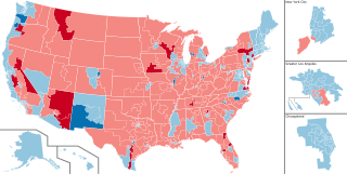
The 2022 United States House of Representatives elections were held on November 8, 2022, as part of the 2022 United States elections during incumbent president Joe Biden's term. Representatives were elected from all 435 U.S. congressional districts across each of the 50 states to serve in the 118th United States Congress, as well as five non-voting members of the U.S. House of Representatives from the District of Columbia and four of the five inhabited insular areas. Numerous other federal, state, and local elections, including the 2022 U.S. Senate elections and the 2022 U.S. gubernatorial elections, were also held on the same date. This was the first election after the 2020 redistricting cycle.


