
The Arctic Archipelago, also known as the Canadian Arctic Archipelago, is an archipelago lying to the north of the Canadian continental mainland, excluding Greenland and Iceland.
The Amundsen Glacier is a major Antarctic glacier, about 7 to 11 km wide and 150 km (80 nmi) long. It originates on the Antarctic Plateau where it drains the area to the south and west of Nilsen Plateau, then descends through the Queen Maud Mountains to enter the Ross Ice Shelf just west of the MacDonald Nunataks.

Ferrar Glacier is a glacier in Antarctica. It is about 35 nautical miles long, flowing from the plateau of Victoria Land west of the Royal Society Range to New Harbour in McMurdo Sound. The glacier makes a right (east) turn northeast of Knobhead, where it where it is apposed, i.e., joined in Siamese-twin fashion, to Taylor Glacier. From there, it continues east along the south side of Kukri Hills to New Harbor.

King Edward VII Land or King Edward VII Peninsula is a large, ice-covered peninsula which forms the northwestern extremity of Marie Byrd Land in Antarctica. The peninsula projects into the Ross Sea between Sulzberger Bay and the northeast corner of the Ross Ice Shelf, and forms part of the Ross Dependency. Edward VII Peninsula is defined by the Ross Ice Shelf on the southwest, Okuma Bay on the west, and to the east by Sulzberger Bay and the Saunders Coast, all essentially on the Ross Sea / Southern Ocean in Antarctica. The northwest extremity of the peninsula is Cape Colbeck. Edward VII Peninsula is located at 77°40′S155°00′W.
Prince Harald Coast is a portion of the coast of Queen Maud Land, Antarctica, encompassing Lutzow-Holm Bay, lying between Riiser-Larsen Peninsula, at 34° E, and the east entrance point of Lutzow-Holm Bay, marked by the coastal angle at 40° E. It was discovered during a flight on February 4, 1937, by Viggo Widerøe, Nils Romnaes, and Mrs. Ingrid Christensen of the Lars Christensen Expedition, 1936–1937, and named after the infant son of the Crown Prince of Norway. The portion of the coast to the east of it is the Prince Olav Coast.

Riiser-Larsen Ice Shelf is an ice shelf about 250 miles (400 km) long on the coast of Queen Maud Land, Antarctica, extending from Cape Norvegia in the north to Lyddan Island and Stancomb-Wills Glacier in the south.

The Ford Ranges are a collection of mountain groups and ranges standing east of Sulzberger Ice Shelf and Block Bay in the northwest part of Marie Byrd Land, Antarctica.

Hut Point Peninsula is a long, narrow peninsula from 2 to 3 nautical miles wide and 15 nautical miles long, projecting south-west from the slopes of Mount Erebus on Ross Island, Antarctica. McMurdo Station (US) and Scott Base (NZ) are Antarctic research stations located on the Hut Point Peninsula.

Cape Evans is a rocky cape on the west side of Ross Island, Antarctica, forming the north side of the entrance to Erebus Bay.
Schweitzer Glacier is a glacier which drains west along the north side of Littlewood Nunataks into Vahsel Bay. The Lerchenfeld Glacier, trending west-northwestward, coalesces with the lower portion of this glacier. Discovered by the German Antarctic Expedition, 1911–12, under Wilhelm Filchner. He named it for Major Schweitzer, first president of the German Antarctic Expedition Society.

Erebus Glacier is a glacier draining the lower southern slopes of Mount Erebus, Ross Island, Antarctica. It flows west to Erebus Bay where it forms the floating Erebus Glacier Tongue. It was named in association with Mount Erebus by the British National Antarctic Expedition, 1901–04, under Robert Falcon Scott.
The Brattstrand Bluffs are rock cliffs on the coast of Antarctica, about 6 kilometres (4 mi) east-north-east of Hovde Island and Amanda Bay. They were first mapped from aerial photographs taken by the Norwegian Lars Christensen Expedition of 1936, and named Brattstranda.

Browns Glacier is a small glacier 4 nautical miles (7 km) north of Chaos Glacier, flowing westward into the northern extremity of Ranvik Bay. The glacier was charted by Norwegian cartographers from air photographs taken by the Lars Christensen Expedition (1936–37), and was further identified in John H. Roscoe's 1952 study of this area from U.S. Navy Operation Highjump (1946–47) photography. It was named by Roscoe for Lieutenant (j.g.) Eduardo P. Brown, U.S. Navy, photographic officer with the western task group of Operation Highjump.
Chaos Glacier is a glacier 4 nautical miles (7 km) south of Browns Glacier, flowing westward from Ingrid Christensen Coast into the central part of Ranvik Bay. It was mapped by Norwegian cartographers from air photos taken by the Lars Christensen Expedition (1936–37), and named by John H. Roscoe in a 1952 study of U.S. Navy Operation Highjump aerial photography of this coast. The name alludes to the jumbled, chaotic, appearance of the terminal glacial flowage.
Ranvik Glacier is a broad glacier flowing into the southern part of Ranvik Bay in the southeast part of Prydz Bay. Mapped by Norwegian cartographers from air photos taken by the Lars Christensen Expedition (1936–37), and named Ranvikbreen for its association with Ranvik Bay.
Ranvik Island is a rocky island, 1.5 nautical miles (2.8 km) long, which is the largest island in the southern part of the Rauer Islands. It lies at the northern end of Ranvik Bay, about 3 nautical miles (5.6 km) northwest of Browns Glacier. Mapped by Norwegian cartographers, as being connected to the mainland, from air photos taken by the Lars Christensen Expedition (1936–37). They gave the name "Ranviktangen" because of its association with Ranvik Bay. The Advisory Committee on Antarctic Names (US-ACAN) has approved John H. Roscoe's 1952 recommendation that the Norwegian name be amended to Ranvik Island. Roscoe's examination of this area in air photos taken by U.S. Navy Operation Highjump (1946–47) determined that the feature described is actually separated from the mainland.
Ranvika is a cove on the east coast of Peter I Island, in the Bellingshausen Sea off the coast of the Antarctic.
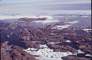
The Rauer Islands are a group of rocky coastal islands which lie between Sorsdal Glacier Tongue and Ranvik Bay, in the southeast part of Prydz Bay. Discovered and roughly charted in February 1935 by a Norwegian expedition under Captain Klarius Mikkelsen. He named them Rauer, probably after the island lying in Oslofjorden opposite Tønsberg, Norway.
