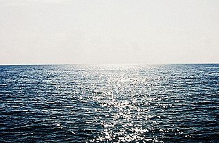
The Arabian Sea is a region of sea in the northern Indian Ocean, bounded on the west by the Arabian Peninsula, Gulf of Aden and Guardafui Channel, on the northwest by Gulf of Oman and Iran, on the north by Pakistan, on the east by India, and on the southeast by the Laccadive Sea and the Maldives, on the southwest by Somalia. Its total area is 3,862,000 km2 (1,491,000 sq mi) and its maximum depth is 4,652 meters (15,262 ft). The Gulf of Aden in the west connects the Arabian Sea to the Red Sea through the strait of Bab-el-Mandeb, and the Gulf of Oman is in the northwest, connecting it to the Persian Gulf.

British Somaliland, officially the Somaliland Protectorate, was a crown colony and protectorate of the United Kingdom in modern Somaliland. During its existence, the territory was bordered by Italian Somalia, French Somali Coast and Abyssinia. From 1940 to 1941, it was occupied by the Italians and was part of Italian East Africa.

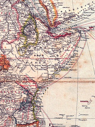
Cape Guardafui is a headland in the autonomous Puntland region in Somalia. Coextensive with Puntland's Gardafuul administrative province, it forms the geographical apex of the Horn of Africa. Its shore at 51°27'52"E is the second easternmost point on mainland Africa after Ras Hafun. The offshore oceanic strait Guardafui Channel is named after it.
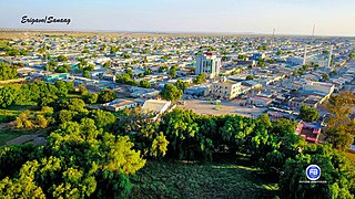
Erigavo, also spelled as Erigabo, is the capital and largest city of the Sanaag region of Somaliland.

Fazul Abdullah Mohammed was a Comorian-Kenyan member of al-Qaeda, and the leader of its presence in East Africa. Mohammed was born in Moroni, Comoros Islands and had Kenyan as well as Comorian citizenship. He spoke French, Swahili, Arabic, English, and Comorian.

Kismayo is a port city in the southern Lower Juba province of Somalia. It is the commercial capital of the autonomous Jubaland region.

Ras Hafun, also known as Cape Hafun, is a promontory in the northeastern Bari region of the Puntland state in Somalia. Jutting out into the Guardafui Channel, it constitutes the easternmost point in Africa. The area is situated near the Cape Guardafui headland. It is joined to the mainland at the town of Foar, by a sand spit 20.0 km (12.4 mi) long, 1.0–3.0 km (0.62–1.86 mi) in width, and 5.0 m (16.4 ft) above sea level. The fishing town of Hafun is located on the promontory, 2.0 km (1.2 mi) east of the sand spit.

Merca is the capital city of the Lower Shebelle province of Somalia, a historic port city in the region. It is located approximately 109 km (68 mi) to the southwest of the nation's capital Mogadishu. Merca is the traditional home territory of the Bimal clan and was the center of the Bimal revolt.
The Bajuni Islands are an archipelago in southern Somalia. They are situated in the Somali sea off the southern coast of Jubaland, from Kismayo to Ras Kiyamboni.

The Battle of Jilib was a battle in the 2006 Somali War fought by the Islamic Courts Union (ICU) and affiliated militias against Ethiopian and Transitional Federal Government (TFG) forces for control of the town of Jilib. It began on 31 December 2006, when ICU forces dug in and defended the town to prevent approach to Kismayo, the last stronghold of the ICU.
Kamboni is a town in the Badhaadhe district of Lower Juba region, Somalia, which lies on a peninsula near the border with Kenya. It is the southernmost town in Somalia. The tip of that peninsula is called Ras Kamboni. The town is located 274 kilometers south of Kismayo. The Town population is 79,000. American officials have said that it has served as a training camp for extremists with connections to Al-Qaeda; al-Sharq al-Awsat reported in May 1999 that al-Qaeda was installing sophisticated communications equipment in the camp.

The Battle of Ras Kamboni was a battle in the Somalia War (2006–2009) fought by the Islamic Courts Union (ICU) and affiliated militias against Ethiopian and the Somali Transitional Federal Government (TFG) forces for control of Ras Kamboni, a town near the Kenyan border which once served as a training camp for the militant Islamist group Al-Itihaad al-Islamiya.

Hizbul Islam, also known as Hizbul Islaami, Hisbi Islam, or Hezb-ul Islam, was a Somali Islamist group formed after four Islamist groups merged to oppose the new Somali government of President Sheikh Sharif Ahmed. The four groups were: Hassan Aweys' the ARS-A, Jabhatul Islamiya, Hassan Abdullah Hersi al-Turki's the Mu'askar Ras Kamboni and Muaskar Anole, the Marehan clan's Militia and Harti clan's militia. These groups previously took part in the fighting against the Ethiopian occupation of Somalia.
The Baraawe raid, code named Operation Celestial Balance, was a helicopter assault by United States Special Operations Forces against the al-Qaeda-linked terrorist Saleh Ali Saleh Nabhan and associated al-Shabaab militants near the town of Baraawe in southern Somalia.
Essina was an ancient Proto-Somali emporium located on the southeastern coast of Somalia in the Horn of Africa.
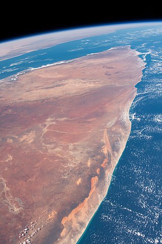
Somalia's coastline consists of the Gulf of Aden to the north, the Guardafui Channel to the northeast and the Indian Ocean to the east. The total length of the coastline is approximately 3333 km, giving the country the longest coastline on mainland Africa. The country has second-longest coastline in all of Africa, behind the island nation of Madagascar.

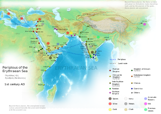
The Guardafui Channel is an oceanic strait off the tip of the Horn of Africa that lies between the Puntland region of Somalia and the Socotra governorate of Yemen to the west of the Arabian Sea. It connects the Gulf of Aden to the north with the Indian Ocean to the south. Its namesake is Cape Guardafui, the very tip of the Horn of Africa. Notable places of interest include the Alula Lagoon.

The Isaaq Sultanate was a Somali kingdom that ruled parts of the Horn of Africa during the 18th and 19th centuries. It spanned the territories of the Isaaq clan in modern-day Somaliland and Ethiopia. The sultanate was governed by the Rer Guled branch of the Garhajis clan and is the pre-colonial predecessor to the modern Republic of Somaliland.

Abdallah Mohamed Shihiri was a senior Khusuusi member of the Somali Dervish movement and was part of the movement since its inception. He was long time companion and a childhood friend of Mohamed Abdullah Hassan and notable weapons smuggler. He belonged to the Adan Madoba sub-clan of the Habr Je'lo clan of the Isaaq clan family.
German colonial efforts on the Somali coast were pursued from 1885 to 1890. Representatives of the German East Africa Company signed friendship and protection treaties with local rulers in the coastal cities of Somalia in 1885 and 1886 with the aim of acquiring areas north of Wituland. In 1888 and 1890, respectively, the project, which overlapped with British and Italian claims, was abandoned.
