Rasor Off-Highway Vehicle Area

Last updated

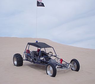
Rasor Off-Highway Vehicle Area is a remote public use area for the off-highway vehicle user located in the Mojave Desert about 50 miles (80 km) east of Barstow, California, administered by the Bureau of Land Management.

Mojave Desert desert in southwestern United States

The Mojave Desert is an arid rain-shadow desert and the driest desert in North America. It is in the Southwestern United States, primarily within southeastern California and southern Nevada, and it occupies 47,877 sq mi (124,000 km2). Very small areas also extend into Utah and Arizona. Its boundaries are generally noted by the presence of Joshua trees, which are native only to the Mojave Desert and are considered an indicator species, and it is believed to support an additional 1,750 to 2,000 species of plants. The central part of the desert is sparsely populated, while its peripheries support large communities such as Las Vegas, Barstow, Lancaster, Palmdale, Victorville, and St. George.

Barstow, California City in California, United States

Barstow is a city in San Bernardino County, California, United States. The population was 22,639 at the 2010 census. Barstow is located 67 miles (108 km) north of San Bernardino.

Bureau of Land Management agency within the United States Department of the Interior

The Bureau of Land Management (BLM) is an agency within the United States Department of the Interior that administers more than 247.3 million acres (1,001,000 km2) of public lands in the United States which constitutes one eighth of the landmass of the country. President Harry S. Truman created the BLM in 1946 by combining two existing agencies: the General Land Office and the Grazing Service. The agency manages the federal government's nearly 700 million acres (2,800,000 km2) of subsurface mineral estate located beneath federal, state and private lands severed from their surface rights by the Homestead Act of 1862. Most BLM public lands are located in these 12 western states: Alaska, Arizona, California, Colorado, Idaho, Montana, Nevada, New Mexico, Oregon, Utah, Washington and Wyoming.

Contents

Besides the remote nature of the area, another attraction is the historic 19th century Mojave Road which traverses the riding area into the Mojave National Preserve.

Mojave Road

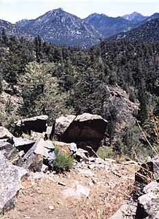
The Mojave Road, also known as Old Government Road, is a historic route and present day dirt road across what is now the Mojave National Preserve in the Mojave Desert in the United States. This rough road stretched 147 miles (237 km) from Beale's Crossing, to Fork of the Road location along the north bank of the Mojave River where the old Mojave Road split off from the route of the Old Spanish Trail/Mormon Road.

Mojave National Preserve

Mojave National Preserve is a United States National Preserve located in the Mojave Desert of San Bernardino County, California, USA, between Interstate 15 and Interstate 40. The preserve was established October 31, 1994, with the passage of the California Desert Protection Act by the US Congress. Previously, it was the East Mojave National Scenic Area, under the jurisdiction of the Bureau of Land Management. Mojave National Preserve is vast. At 1,600,000 acres (650,000 ha), it is the third largest unit of the National Park System in the contiguous United States.

Rasor has rolling hills, open valleys, and sand dunes that invite riders willing to travel through this remote area. Elevations range from near 2,427 feet (740 m) elevation down to around 1,275 feet (389 m) elevation at the Mojave River. Vegetation consists of creosote scrub, some annual grasses and wild flowers.

Mojave River intermittent river in California

The Mojave River is an intermittent river in the eastern San Bernardino Mountains and the Mojave Desert in San Bernardino County, California, United States. Most of its flow is underground, while its surface channels remain dry most of the time, with the exception of the headwaters and several bedrock gorges in the lower reaches.

Creosote chemical compound

Creosote is a category of carbonaceous chemicals formed by the distillation of various tars and pyrolysis of plant-derived material, such as wood or fossil fuel. They are typically used as preservatives or antiseptics.

Location

The area is located at 35°06′32″N116°08′37″W / 35.108780°N 116.143630°W / 35.108780; -116.143630 between Interstate 15 and the Mojave National Preserve, about 25 miles (40 km) southwest of Baker. Access roads are Basin Road and Rasor Road east of the I-15. Both of these roads are graded dirt roads.

Route 15, consisting of the contiguous segments of State Route 15 and Interstate 15 (I-15), is a major north–south state highway and Interstate Highway in the U.S. state of California, connecting San Bernardino, Riverside, and San Diego Counties. The route consists of the southernmost 289.24 miles (465.49 km) of I-15, which extends north through Nevada, Arizona, Utah, Idaho, and Montana to the Canada–US border. It is a major thoroughfare for traffic between San Diego and the Inland Empire, as well as between Southern California, Las Vegas, Nevada, and points beyond.

Activities

Most visitors ride motorcycles or ATVs, drive sandrails or tour the area in four-wheel drive vehicles. The easily accessed areas off the Rasor Road exit are used extensively for OHV and sand rail staging and play. Due to the remoteness of the area, there have been no requests for competitive event permits, leaving this area exclusively for casual riders.

Sandrail

A sandrail, or sand rail, or rail, is a lightweight off-road motor vehicle specifically built for traveling in sandy terrain. Similar in some respects and often mistakenly referred to as a dune buggy or sand car, a sandrail is a different type of speciality vehicle. Sandrails are popularly operated on actual sand dunes. Sandrails can be driven on other types of terrain but are designed specifically for sand.

Four-wheel drive type of drivetrain with four driven wheels

Four-wheel drive, also called 4×4 or 4WD, refers to a two-axled vehicle drivetrain capable of providing torque to all of its wheels simultaneously. It may be full-time or on-demand, and is typically linked via a transfer case providing an additional output drive-shaft and, in many instances, additional gear ranges.

Off-road vehicle

An off-road vehicle is considered to be any type of vehicle which is capable of driving on and off paved or gravel surface. It is generally characterized by having large tires with deep, open treads, a flexible suspension, or even caterpillar tracks. Other vehicles that do not travel public streets or highways are generally termed off-highway vehicles, including tractors, forklifts, cranes, backhoes, bulldozers, and golf carts.

There are many opportunities for hiking, rock scrambling, rockhounding, and plant, bird and wildlife watching. There are desert tortoise, a state and federally listed threatened species, in the riding area.

Desert tortoise Informal group of reptiles

The desert tortoises, also known as desert turtles, are two species of tortoise native to the Mojave and Sonoran Deserts of the southwestern United States and northwestern Mexico and the Sinaloan thornscrub of northwestern Mexico. G. agassizii is distributed in western Arizona, southeastern California, southern Nevada, and southwestern Utah. The specific name agassizii is in honor of Swiss-American zoologist Jean Louis Rodolphe Agassiz. Recently, on the basis of DNA, geographic, and behavioral differences between desert tortoises east and west of the Colorado River, it was decided that two species of desert tortoises exist: Agassiz's desert tortoise and Morafka's desert tortoise. G. morafkai occurs east of the Colorado River in Arizona, as well as in the states of Sonora and Sinaloa, Mexico. This species may be a composite of two species.

There are many deep mine shafts in the riding area. Camping is allowed anywhere within the riding area that does not block travel on a road.

Afton Canyon Natural Area

The Afton Canyon Natural Area, managed by the Bureau of Land Management, is located where the Mojave River surfaces due to bedrock. Afton Canyon is designated as an Area of Critical Environmental Concern to protect plant and wildlife habitat, and to preserve scenic values of the Mojave River's riparian area within the canyon. [1]

The Rasor Off-Highway Vehicle Area establishment and use has begun to reverse the heavy off-road vehicles use and damage that occurred in the riverbed and canyon. Restoration projects are ongoing, and have already brought the river's "proper functioning condition" from a "non-functioning" to a "functioning at risk" status. The objectives of the ambitious restoration project are to control exotic plants, particularly the phreatophyte Saltcedar - Tamarix (primarily Tamarix ramosissima and T. parviflora), and restoring critical desert California native plant community "structural elements" for a functioning flora and fauna habitat. [2]

See also

Notes

  1. BLM Archived 2015-12-08 at the Wayback Machine . accessed June 20, 2010 BLM Public domain source]
  2. BLM Archived 2015-12-06 at the Wayback Machine . accessed June 20, 2010 BLM Public domain source

Related Research Articles

Kelso Dunes sand field in the Mojave Desert

Kelso Dunes, also known as the Kelso Dune Field, is the largest field of aeolian sand deposits in the Mojave Desert. The region is protected by the Mojave National Preserve and is located near the town of Baker, San Bernardino County, California, and the Preserve Visitor Center. The dune field covers 45 square miles (120 km2) and includes migrating dunes, vegetation-stabilized dunes, sand sheets, and sand ramps. The tallest dunes rise up to 650 feet (200 m) above the surrounding terrain.

Owens Peak Wilderness

The Owens Peak Wilderness is a 73,767-acre (298.52 km2) wilderness area comprising the rugged eastern face of the Sierra Nevada Mountains. Owens Peak (8,445 ft) is the high point. The land was set aside with the passage of the California Desert Protection Act of 1994 by the US Congress.

Chuckwalla Mountains mountain range

The Chuckwalla Mountains are a mountain range in the transition zone between the Colorado Desert—Sonoran Desert and the Mojave Desert, climatically and vegetationally, in Riverside County of southern California.

Clipper Mountains

The Clipper Mountains are located in the Eastern Mojave Desert and protected within Mojave Trails National Monument, in San Bernardino County, California.

Turtle Mountains (California)

The Turtle Mountains, are located in northeastern San Bernardino County, in the southeastern part of California.

Johnson Valley, California Unincorporated community in California, United States

Johnson Valley is a small unincorporated community in San Bernardino County in Southern California between the Victor Valley and Morongo Basin areas of the High Desert region of California. It is located north of Highway 247 in the Mojave Desert, and north by northwest of Yucca Valley. It is bordered by the San Bernardino Mountains to the south, Lucerne Valley to the west, and Landers to the east.

The Big Morongo Canyon Preserve is a 31,000 acres (130 km2) native plants habitat and wildlife preserve located in the Little San Bernardino Mountains of the Transverse Ranges, in the transition zone between the higher Mojave Desert and lower elevation Colorado Desert section of the Sonoran Desert. Due to its location within this transition zone, the area is especially high in natural diversity. The natural spring fed desert oasis found here is one of the 10 largest Cottonwood and Willow riparian habitats in California. It is also identified by the Audubon Society as one of the most important avian habitat areas in California.

Harper Lake lake of the United States of America

Harper Lake is a dry lake located in the Mojave Desert near the small community of Lockhart, California, in northwestern San Bernardino County of Southern California. The lake is accessible from Harper Lake Road, which runs north off of State Route 58 midway between Boron and Barstow.

Kiavah Wilderness

The Kiavah Wilderness is a federally designated wilderness area located in the Mojave Desert, Scodie Mountains, and Southern Sierra Nevada Mountains in Kern County, California, United States. California State Route 178 connects the town of Lake Isabella, California to state Highway 14 in the east, crossing Walker Pass at the north boundary of the wilderness.

Piper Mountain Wilderness

The Piper Mountain Wilderness is a federally designated wilderness area located in the White Mountains 20 miles (32 km) northeast of Big Pine, California in Inyo County, California.

Dumont Dunes area of sand dunes in the Mojave Desert

Dumont Dunes is an area of the Mojave Desert containing large sand dunes, located approximately 31 miles north of Baker, California on California State Route 127. Bordered by steep volcanic hills and the slow running Amargosa River, the region is easily recognized from a distance by its distinctive sand dunes. The elevation here varies from 700 feet, at the river, to 1200 feet at the top of Competition Hill, the tallest of the dunes.

Chimney Peak Wilderness

The Chimney Peak Wilderness is a 13,134-acre (53.15 km2) wilderness area located 20 miles (32 km) northwest of Ridgecrest, in southeastern Tulare County, California.

Lake Manix

Lake Manix is a former lake fed by the Mojave River in the Mojave Desert. It lies within San Bernardino County, California. Located close to Barstow, this lake had the shape of a cloverleaf and covered four basins named Coyote, Cady/Manix, Troy and Afton. It covered a surface area of 236 square kilometres (91 sq mi) and reached an altitude of 543 metres (1,781 ft) at highstands, although poorly recognizable shorelines have been found at altitudes of 547–558 metres (1,795–1,831 ft). The lake was fed by increased runoff during the Pleistocene and overflowed into the Lake Mojave basin and from there to Lake Manly in Death Valley, or less likely into the Bristol Lake basin and from there to the Colorado River.

Jawbone Canyon

Jawbone Canyon is a geographic feature in the Mojave Desert and a Bureau of Land Management area located in Kern County, California, 20 miles (32 km) north of Mojave on CA 14. The area is a popular destination for hikers and off road vehicle enthusiasts.

The California Desert Protection Act of 2010 was legislation proposed by U.S. Senator Dianne Feinstein. The stated aim of the legislation was to provide for conservation, enhanced recreation opportunities, and development of renewable energy in the California Desert Conservation Area.

Mojave Trails National Monument

Mojave Trails National Monument is a large U.S. National Monument located in the state of California between Interstates 15 and 40. It partially surrounds the Mojave National Preserve. It was designated by President Obama on February 12, 2016 along with Castle Mountains National Monument and Sand to Snow National Monument. It is under the control of the Bureau of Land Management.

Sand to Snow National Monument protected area in California

Sand to Snow National Monument is a U.S. National Monument located in San Bernardino County and into northern Riverside County, Southern California.

References