Raulibandha

Last updated

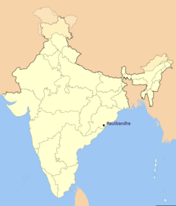
Raulibandha is a village in Malada Gram Panchayat, Ganjam district in the state of Odisha, India. [1]

Contents

Raulibandha Village in Ganjam district, Orissa. India-locator-raulibandha.png
Raulibandha Village in Ganjam district, Orissa.

Geography

Raulibandha is located 3 km from the State Highway connecting Humma-Purushottampur at the nearest village Santoshpur. The total area of the village is 324.545 acres (131.339 ha). [2]

Demography

As of 2011 census, Raulibandha has a total population of 687 (male:47%, female:53%). Raulibandha has a literacy rate of 69% (male:89%, female:53%)lower than the state average literacy rate of 73%. 16% of the population is under 6 years of age. Average Sex Ratio of the village is 1127 which is higher than Odisha state average of 979, whereas Child Sex Ratio is only 909, lower than Odisha average of 941. [3] Since Ganjam district has border with Andhra Pradesh, like many other places- majority of population in Raulibandha is Telugu by mother tongue.

Life of Raulibandha

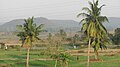
Raulibandha has one primary school to study up to 5th class, then students have to go to Santoshpur, located at 3 km for high school. People of Raulibandha are mostly engaged in agricultural activities. Rice, ground nut, cashew nut, different pulses, mustard, etc.

Few families have migrated to Chirmiri, Chhattisgarh in search of work mostly in coal mines.

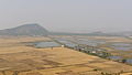
According to Risk Assessment, Vulnerability Analysis and Capacity Analysis by the state government, Raulibandha is vulnerable to flood by the nearby river Rishukulya situated on the other side of the village to Municipentha. [4]

Footnotes

  1. "Archived copy". Archived from the original on 23 August 2011. Retrieved 20 December 2009.{{cite web}}: CS1 maint: archived copy as title (link)
  2. http://orissa.gov.in/revenue/ADMN_UNIT/Ganjam/Chatrapur/Mallada.htm [ dead link ]
  3. "Raulibandha Village Population - GANJAM - Ganjam, Orissa".
  4. http://ganjam.nic.in/ddmp/002.htm [ dead link ]

Coordinates: 19°26′36″N84°59′17″E / 19.443280°N 84.988057°E / 19.443280; 84.988057

Related Research Articles

Gopalpur is a coastal town and a Notified Area Council on the Bay of Bengal coast in Ganjam district in the southern part of Odisha, India. Today it is a commercial port, a famous sea beach and a tourist destination. Gopalpur is around 15 km from Berhampur. The reconstruction of an all weather port including new berths is under development.

Hirakud Town in Odisha, India

Hirakud is a small township located in Sambalpur in Odisha. It was a Notified Area Council (NAC) which was later included along with Burla in Sambalpur city to become a Municipal Corporation. This city is a hub of HINDALCO, an Indian aluminium and copper manufacturing company. Hirakud Dam, is one of the most visited tourist spot. It is one of the longest and largest dams in the world. It is constructed across the Mahanadi river between the Gandhi Minar in North and the Nehru Minar in the South, which connects these two hills. The shoreline spans around 640 km. This dam had a generating capacity of 290MW.

Kabisuryanagar is a town and a NAC in Ganjam district in the Indian state of Odisha.

Kodala is a town and a Notified Area Council in Ganjam District in the Indian State of Odisha.

Polasara is a town and a notified area council in Ganjam district in the Indian state of Odisha.

Purusottampur is a town and a notified area committee in Ganjam district in the Indian state of Odisha.

Rambha is a town and a notified area council in Ganjam district in the Indian state of Odisha.

Ampani is a town in the Kalahandi district of the state of Odisha, in India. It is a gram panchayat that comes under Kokasara tehsil. It is 15 km from its main town and blocks Kokasara.

Khajuriya Sarki is a village near Dhebarua in Shoratgarh Assembly Constituency of Siddharthnagar District, Uttar Pradesh state, India. The village has a nearby railway station Barhni on the Gorakhpur–Gonda Indian Railways. It is 6 km from the Nepal border Krishnanagar (JhandeNagar). The famous personality late Baadshah Mehdi Hasan Khan belongs from this village.

Golia, Ganjam Rural area in Odisha, India

Golia is a village located in the Ganjam District of the Indian state of Odisha. It is governed by a panchayat, which also governs several nearby villages, and is famous for the large number of turtles in Nelia Pond beside the temple of Shiva. Golia is 76 kilometres (47 mi) away from the city of Brahampur and 159 kilometres (99 mi) away from the state capital, Bhubaneswar.

Manakawad is a village in Dharwad district of Karnataka, India.

Mujagada, Ganjam Village in Odisha, India

Mujagada is a large village located near Bhanjanagar of Ganjam district in Orissa. It is located 89 kilometres (55 mi) north of district headquarters, Chhatrapur, and 159 kilometres (99 mi) from the state capital Bhubaneswar. Asika, Hinjilicut, Phulabani, and Berhampur are nearby. Oriya is the local language here. The main occupation of this village is agriculture.

Gopaipali is a small village under Barpali block in Bargarh District with village code 72500 as per 2001 Census.

Baunsalundi is a small village in Gram Panchayat Baunsalundi located near Bhanjanagar of Ganjam district in Odisha. It is located 91 km towards North from District Headquarters Chhatrapur. 162 km from State capital Bhubaneswar.. Odia is the Language here.

Oranda is a village located in the Gurudijhatia Block of the Athagad Tehsil of the Cuttack District of the Indian state of Odisha.

Dihapadhal is a Village located near Bhanjanagar of Ganjam district in Orissa. It is located 104 km towards North from District Headquarters Chhatrapur. 170 km from State capital Bhubaneswar. Bhanjanagar, Lalsingi, Jilundi, Baunsalundi, Inginathi, Sanakodanda are the nearby Villages to Dihapadhal. Odia is the Local Language here.

Karatali is a village under Chatrapur tahasil in Ganjam district in the Indian state of Odisha.

Khireitangiri is a village located in Patna Tehsil in the Kendujhar District in the Indian state of Odisha.

Majursahi is a village of Koksara Block in Dharmagarh Sub-Division in Kalahandi District of Odisha State. This village comes under Phupagaon Panchayat of Kokasara Tehasil in Kalahandi District. It also comes under Kasibahal RI circle. Majursahi is 6.5 km distance from Koksara and 60 km distance from its District Headquarters Bhawanipatna. And about 500 km away from its State Capital Bhubaneswar.

Barabatia is a village in Bhadrak district, Odisha. It is comes under the Tihidi block and governed locally under the panchayata raj system with the panchayat headed by a sarpanch. The village comes under the Harisinghpur Panchayat. Being a rural area the traditional culture, festival and heritage have flourished here.