
Kaktovik is a city in North Slope Borough, Alaska, United States. The population was 239 at the 2010 census.

Oulu is a city, municipality and a seaside resort of 208,939 inhabitants in the region of North Ostrobothnia, Finland. It is the most populous city in Northern Finland and the fifth most populous in the country after: Helsinki, Espoo, Tampere and Vantaa, and the fourth largest urban area in the country after Helsinki, Tampere and Turku. Oulu's neighbouring municipalities are: Hailuoto, Ii, Kempele, Liminka, Lumijoki, Muhos, Pudasjärvi, Tyrnävä and Utajärvi.

Alajärvi is a town and municipality of Finland. It is located in the South Ostrobothnia region. The town has a population of 9,402 and covers an area of 1,056.74 square kilometres (408.01 sq mi) of which 47.99 km2 (18.53 sq mi) is water. The population density is 9.32 inhabitants per square kilometre (24.1/sq mi). The town is unilingually Finnish; there are few immigrants.

Alavus is a town and municipality of Finland. It is located in the province of Western Finland and is part of the Southern Ostrobothnia region, 52 kilometres (32 mi) southeast of Seinäjoki, 138 kilometres (86 mi) north of Tampere and 319 kilometres (198 mi) north of Helsinki. The town has a population of 11,275 and covers an area of 1,151.46 square kilometres (444.58 sq mi) of which 52.31 km2 (20.20 sq mi) is water. The population density is 14.26 inhabitants per square kilometre (36.9/sq mi). Neighbouring municipalities are Alajärvi, Kuortane, Seinäjoki, Virrat and Ähtäri.
Asikkala is a municipality of Finland. Its seat is in Vääksy, at the shores of the Lake Päijänne. It is located in the province of Southern Finland and is part of the Päijänne Tavastia region. Asikkala's neighboring municipalities are Hämeenlinna, Heinola, Hollola, Lahti, Padasjoki and Sysmä.

Brändö is an island municipality of Åland, Finland. Characteristics of Brändö are the numerous assembly of islands and islets, most important of which are linked by bridges and causeways. The municipality has a population of 451 and covers an area of 1,643.21 square kilometres of which 1,540.41 km2 (594.76 sq mi) is water. The population density is 4.17 inhabitants per square kilometre (10.8/sq mi). The municipality is unilingually Swedish and 84.6% of the population are Swedish speakers.

Oulunsalo is former municipality in the region of Northern Ostrobothnia, in Finland. Along with Haukipudas, Kiiminki and Yli-Ii it lost its municipal status and was merged with the city of Oulu on 1 January 2013. The municipality had a population of 9,746 and covered an area of 211.22 square kilometres (81.55 sq mi), of which 127.86 km2 (49.37 sq mi) is water. The population density is 116.915/km2 (302.81/sq mi). The municipality was founded in 1882.

Hailuoto is an island and a municipality in Northern Ostrobothnia region, Finland. The population of Hailuoto is 953, which make it the smallest municipality in Northern Ostrobothnia and the former Oulu Province in terms of population. The municipality covers an area of 200.53 km2 (77.43 sq mi) of which 1.70 km2 (0.66 sq mi) is inland water. The population density is 4.75/km2 (12.3/sq mi). Of all the Finnish islands in Finland's sea areas, Hailuoto is the third largest after Fasta Åland and Kimitoön.
Lumijoki is a municipality of Finland.
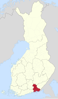
Kymenlaakso is a region in Finland. It borders the regions of Uusimaa, Päijät-Häme, South Savo and South Karelia and Russia. Its name means literally The Valley of River Kymi. Kymijoki is one of the biggest rivers in Finland with a drainage basin with 11% of the area of Finland. The city of Kotka with 51,000 inhabitants is located at the delta of River Kymi and has the most important import harbour in Finland. Other cities are Kouvola further in the inland which has after a municipal merger 81,000 inhabitants and the old bastion town Hamina.
Siikajoki is a municipality of Finland. It is part of the North Ostrobothnia region. The municipality has a population of 5,038 (31 March 2021) and covers an area of 1,653.89 square kilometres (638.57 sq mi) of which 601.94 km2 (232.41 sq mi) is water. The population density is 4.79 inhabitants per square kilometre (12.4/sq mi). Neighbour municipalities are Hailuoto, Liminka, Lumijoki, Raahe and Siikalatva.
Marjaniemi Lighthouse is a lighthouse located in the village of Marjaniemi at the westernmost point of Hailuoto island on the Gulf of Bothnia. The lighthouse is located approximately 50 kilometres (31 mi) west of Oulu. The lighthouse was designed by Axel Hampus Dalström as his fourth lighthouse and it was first lit in 1872.
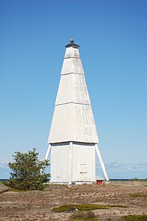
The Keskiniemi beacon tower, often referred to as the Karvo beacon tower, is a historic daymark located on a promontory of Keskiniemi in the northwestern part of Hailuoto island in the Gulf of Bothnia in Finland. The tower was built in 1858 to alert the vessels about sandbars reaching northwest from the site. It is the oldest surviving navigational aid on Hailuoto island. The tower has structural similarities with the Härkmeri beacon tower built in 1857.

Laitakari beacon tower is a daymark located on the island of Laitakari in the Gulf of Bothnia in Finland. The island is located east-northeast of Hailuoto and is within the municipal boundaries of the City of Oulu. There has been a navigational aid on the island since the 1750s, and a beacon tower has been marked on a chart dated in 1785.
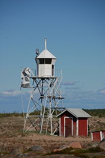
Keskiniemi Light is a sector light tower located in the northwestern promontory of Hailuoto island in the Gulf of Bothnia in Finland. It is located next to the Keskiniemi beacon tower built in 1858.

Kimitoön is a municipality and island of Finland. It was created on 1 January 2009, when the municipalities of Dragsfjärd, Kimito and Västanfjärd were consolidated into a single municipality.
Philip Henry Askeli was a Finnish American draftsman, labor activist and therapist.

Finnish regional road 816 or Hailuoto Road is a Finnish road between the Kempele municipality and the Hailuoto Island. The length of the road is 56 kilometres (35 mi) which includes a 6.9-kilometre (4.3 mi) ferry connection between mainland and the Hailuoto Island.
