Route 27 is a state highway in New Jersey, United States. It runs 38.53 mi (62.01 km) from U.S. Route 206 in Princeton, Mercer County northeast to an interchange with Route 21 and Broad Street in Newark, Essex County. The route passes through many communities along the way, including New Brunswick, Metuchen, Rahway, and Elizabeth. Route 27 is a two- to four-lane undivided highway for most of its length, passing through a variety of urban and suburban environments. It intersects many roads along the way, including Route 18 in New Brunswick, Interstate 287 in Edison, the Garden State Parkway in Woodbridge Township, Route 35 in Rahway, Route 28 in Elizabeth, and U.S. Route 22 in Newark. Route 27 crosses the Raritan River on the Albany Street Bridge, which connects Highland Park on the east with New Brunswick on the west.

Route 495 is a 3.45-mile-long (5.55 km) freeway in Hudson County, New Jersey, in the United States that connects the New Jersey Turnpike at exits 16E and 17 in Secaucus to New York State Route 495 (NY 495) inside the Lincoln Tunnel in Weehawken, providing access to Midtown Manhattan. The road is owned and operated by the New Jersey Turnpike Authority (NJTA) between the New Jersey Turnpike and Route 3, the New Jersey Department of Transportation (NJDOT) between Route 3 and Park Avenue near the Union City–Weehawken border, and by the Port Authority of New York and New Jersey (PANYNJ) east of Park Avenue, including the helix used to descend the New Jersey Palisades to reach the entrance of the Lincoln Tunnel. Route 495 is mostly a six-lane freeway with a reversible bus lane used during the morning rush hour. The bus lane, which runs the entire length of the freeway, continues into the Lincoln Tunnel's center tube.

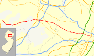
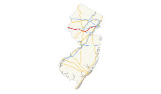
Route 24 is a state highway in New Jersey, United States, that extends 10.42 mi (16.77 km) from a junction with Interstate 287 in Hanover Township in Morris County, passing southeast through Essex County, and ends at a junction with Interstate 78 in Springfield Township in Union County. The route is a four- to six-lane freeway its entire length.

Route 62 is a 0.47-mile-long (0.76 km) state highway in the U.S. state of New Jersey. It begins at the centerline of U.S. Route 46 along Union Boulevard in the community of Totowa and continues northward to the merge of the Interstate 80 westbound off-ramp at Exit 55B, where Route 62 ends. The route continues as Passaic County Route 646 in both directions, heading northbound to Paterson and southbound to Little Falls.
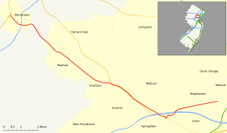
Route 124 is a state highway in the northern part of New Jersey in the United States that is 14.74 mi (23.72 km) long. It is the eastern section of what used to be Route 24 before that road was realigned to its current freeway alignment. The western end is at an intersection with U.S. Route 202 (US 202) and County Route 510 (CR 510) in Morristown, Morris County; the eastern end continues as CR 603 on Springfield Avenue at the border between Maplewood and Irvington in Essex County. The route runs through suburban areas of Morris County, passing through Madison and Chatham. It interchanges with Route 24 on the border of Millburn, Essex County and Summit, Union County and serves as a frontage road for that route. Upon splitting from Route 24, Route 124 continues east through Springfield Township, Union Township, and Maplewood to its eastern terminus.
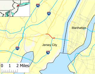
Route 139 is a state highway in Jersey City, New Jersey in the United States that heads east from the Pulaski Skyway over Tonnele Circle to the state line with New Jersey and New York in the Holland Tunnel, which is under the Hudson River, to New York City. The western portion of the route is a two level highway that is charted by the New Jersey Department of Transportation as two separate roadways: The 1.45-mile (2.33 km) lower roadway (Route 139) between U.S. Route 1/9 over Tonnele Circle and Interstate 78 at Jersey Avenue, and the 0.83-mile (1.34 km) upper roadway running from County Route 501 and ending where it joins the lower highway as part of the 12th Street Viaduct, which ends at Jersey Avenue. The lower roadway is listed on the federal and NJ state registers of historic places since 2005. The eastern 1.32 miles (2.12 km) of the route includes the Holland Tunnel approach that runs concurrent with Interstate 78 on the one-way pair of 12th Street eastbound and 14th Street westbound. Including the concurrency, the total length of Route 139 is 2.77 miles (4.46 km).
U.S. Route 46 is an east–west U.S. Highway completely within the state of New Jersey, running for 75.34 mi (121.25 km), making it the shortest signed, non-spur U.S. Highway. The west end is at an interchange with Interstate 80 (I-80) and Route 94 in Columbia, Warren County on the Delaware River. The east end is in the middle of the George Washington Bridge over the Hudson River in Fort Lee, Bergen County while the route is concurrent with I-95 and US 1-9. Throughout much of its length, US 46 is closely paralleled by I-80. US 46 is a major local and suburban route, with some sections built to or near freeway standards and many other sections arterials with jughandles. The route runs through several communities in the northern part of New Jersey, including Hackettstown, Netcong, Dover, Parsippany-Troy Hills, Wayne, Clifton, Ridgefield Park, Palisades Park, and Fort Lee. It crosses over the Upper Passaic River at several points. The road has been ceremonially named the United Spanish–American War Veterans Memorial Highway.

Route 413 is a 0.76-mile-long (1.22 km) state highway located entirely in the City of Burlington, New Jersey, United States. It is an eastward extension into New Jersey of the longer Pennsylvania Route 413 (PA 413). The western terminus in the middle of the Burlington–Bristol Bridge crossing of the Delaware River at the New Jersey–Pennsylvania state border; the eastern terminus is at an intersection with U.S. Route 130 (US 130). Despite the east–west orientation, Route 413 runs north–south, but PA 413 is signed north–south. Prior to the 1953 renumbering, Route 413 was Route S25, a prefixed spur of Route 25.
The Schuylkill Expressway, locally known as "the Schuylkill", is a two to eight lane freeway through southwestern Montgomery County and the city of Philadelphia, and the easternmost segment of Interstate 76 in the U.S. state of Pennsylvania. It extends from the Valley Forge exit of the Pennsylvania Turnpike in King of Prussia, paralleling its namesake Schuylkill River for most of the route, to the Walt Whitman Bridge in South Philadelphia. It serves as the primary corridor into Philadelphia from points west. Maintenance and planning are administered through PennDOT District 6. Constructed over a period of ten years from 1949 to 1959, a large portion of the expressway predates the 1956 introduction of Interstate Highway System; many of these portions were not built to contemporary standards. The rugged terrain, limited riverfront space covered by the route and narrow spans of bridges passing over the highway have largely stymied later attempts to upgrade or widen the highway. With the road being highly over capacity, it has become notorious for its chronic congestion. In recent years, it is the busiest road in Philadelphia, as well as in the entire commonwealth of Pennsylvania. An average 163,000 vehicles use the road daily in Philadelphia County, and an average of 109,000 use the highway in Montgomery County. Its narrow lane and left shoulder configuration, left lane entrances and exits, common construction activity and generally congested conditions have led to many accidents, critical injuries and fatalities, leading to the highway's humorous nickname of the "Surekill Expressway" or in further embellishment, the "Surekill Distressway" or the “Surekill Crawlway".
Interstate 80 (I-80) is a major Interstate Highway in the United States, running from San Francisco, California eastward to the New York City Metropolitan Area. In New Jersey, I-80 runs for 68.54 miles (110.30 km) from the Delaware Water Gap Toll Bridge at the Pennsylvania state line to its eastern terminus at I-95 in Teaneck, Bergen County. I-95 continues from the end of I-80 to the George Washington Bridge for access to New York City. The highway runs parallel to U.S. Route 46 (US 46) through rural areas of Warren and Sussex counties before heading into more suburban surroundings in Morris County. As the road continues into Passaic and Bergen counties, it heads into more urban areas. The New Jersey Department of Transportation identifies I-80 within the state as the Christopher Columbus Highway.
Interstate 78 (I-78) is an east–west route stretching from Union Township, Lebanon County, Pennsylvania to New York City. In New Jersey, I-78 is called the Phillipsburg–Newark Expressway and the Newark Bay Extension of the New Jersey Turnpike. The highway runs for 67.83 miles (109.16 km) in the northern part of the state of New Jersey from the Interstate 78 Toll Bridge over the Delaware River at the Pennsylvania state line in Phillipsburg, Warren County east to the Holland Tunnel under the Hudson River at the New York state line in Jersey City, Hudson County. The Phillipsburg-Newark Expressway portion of I-78, formally called the Lightning Division Memorial Highway, runs from the Phillipsburg area east across rural areas of western New Jersey before entering suburban areas in Somerset County. The road crosses the Watchung Mountains, widening into a local-express lane configuration at Route 24 as it continues through urban areas to Newark. Here, I-78 intersects the mainline of the New Jersey Turnpike (I-95) and becomes the Newark Bay Extension, crossing the Newark Bay Bridge and continuing to Jersey City. The route, along with Route 139, follows a one-way pair of surface streets to the Holland Tunnel.

Route 58 is a former state highway in the city of Newark, New Jersey and nearby borough of Harrison, New Jersey. The highway ran from Orange and Hecker Streets in Newark, eastbound as a four-lane freeway across the William A. Stickel Memorial Bridge to Harrison, where it terminated at an intersection with County Route 508. The route originates as an alignment of Route 25A, a suffixed spur designated in 1939 of State Highway Route 25. The route was rechristened as Route 58 in the 1953 state highway renumbering. The highway was constructed into Interstate 280 in the 1950s, and the route persisted internally until the 1990s, when it was finally removed as a designation. A stub alignment of Route 58 remains near Hecker and Orange Streets.

Pennsylvania Route 3 is a 24.3-mile (39.1 km) state highway located in the southeastern portion of Pennsylvania. The route connects U.S. Route 322 Business in West Chester with PA 611 in Philadelphia. The route begins in downtown West Chester and heads east out of town as a one-way pair of streets. Between West Chester and Upper Darby Township, PA 3 follows a four-lane divided highway known as West Chester Pike through suburban areas. Along this stretch, the route passes through Edgmont, Newtown Square, Broomall, and Havertown. The route has an interchange with Interstate 476 (I-476) between Broomall and Havertown. Upon reaching Upper Darby, PA 3 heads into Philadelphia along Market Street. In Philadelphia, the route follows multiple one-way pairs, running along Chestnut Street and Walnut Street in West Philadelphia before heading into Center City Philadelphia along Market Street and John F. Kennedy Boulevard and ending at Philadelphia City Hall.
County Route 510, abbreviated CR 510, is a county highway in the U.S. state of New Jersey. The highway extends 29.58 miles (47.60 km) from North Road in Chester to McCarter Highway in Newark.

Delaware Route 48 is a state highway in New Castle County, Delaware. The route runs from DE 41 in Hockessin east to U.S. Route 13 Business in downtown Wilmington. The route passes through suburban areas of Wilmington such as Lancaster Pike, intersecting DE 100 and DE 141. DE 48 continues into Wilmington as Lancaster Avenue and intersects DE 2, where it splits into the one-way pair of Lancaster Avenue eastbound and Second Street westbound. Upon reaching downtown Wilmington, the route intersects Interstate 95 (I-95)/US 202 and DE 4 before continuing to the eastern terminus.

Delaware Route 4 is a state highway in New Castle County, Delaware. The route runs from DE 279 and DE 896 in Newark east to DE 48 in downtown Wilmington. The route passes through suburban areas in northern New Castle County between Newark and Wilmington, intersecting DE 72 in the eastern part of Newark, DE 273 in Ogletown, DE 58 in Christiana, DE 7 in Stanton, DE 141 in Newport, DE 62 and DE 100 between Newport and Wilmington, and Interstate 95 (I-95)/U.S. Route 202 in Wilmington. DE 4 is a four-lane road much of its length.
U.S. Route 22 is a U.S. highway stretching from Cincinnati, Ohio in the west to Newark, New Jersey in the east. In New Jersey, the route runs for 60.53 mi (97.41 km) from the Easton-Phillipsburg Toll Bridge over the Delaware River in Phillipsburg, Warren County to Interstate 78 (I-78), US 1/9, and Route 21 at the Newark Airport Interchange in Newark, Essex County. The road first heads through the Phillipsburg-Alpha area as a surface divided highway before running concurrent with I-78 through mountainous and agricultural sections of western New Jersey between Alpha and east of Clinton in Hunterdon County. For the remainder of the route, US 22 runs to the south of I-78 through mostly suburban areas as a four- to six-lane surface divided highway, passing through Hunterdon, Somerset, Union, and Essex counties. Along this portion, it intersects US 202 and US 206 in Somerville, I-287 in Bridgewater Township, and the Garden State Parkway in Union.
Route 151 was a short, one-way pair state highway in the city of Camden, New Jersey from Dr. Martin Luther King Jr. Boulevard to County Route 537 in the city. There was also an interchange with U.S. Route 30, and the entire roadway was near Interstate 676's Interchange 5A. Route 151 ran along South Tenth Street for eastbound traffic and South Eleventh Street for westbound traffic west of Mount Ephraim Avenue. From there, South Tenth was known as Flanders Avenue and South Eleventh was known as Memorial Avenue. At U.S. Route 30, the route continued bi-directionally as Flanders Avenue until its end at County Route 537.