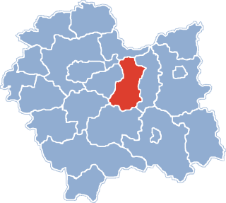
Gmina Łapanów is a rural gmina in Bochnia County, Lesser Poland Voivodeship, in southern Poland. Its seat is the village of Łapanów, which lies approximately 17 kilometres (11 mi) south-west of Bochnia and 34 km (21 mi) south-east of the regional capital Kraków.
Gmina Nowy Wiśnicz is an urban-rural gmina in Bochnia County, Lesser Poland Voivodeship, in southern Poland. Its seat is the town of Nowy Wiśnicz, which lies approximately 8 kilometres (5 mi) south of Bochnia and 40 km (25 mi) south-east of the regional capital Kraków.
Gmina Żegocina is a rural gmina in Bochnia County, Lesser Poland Voivodeship, in southern Poland. Its seat is the village of Żegocina, which lies approximately 21 kilometres (13 mi) south of Bochnia and 46 km (29 mi) south-east of the regional capital Kraków.

Brzeźnica is a village in the administrative district of Gmina Bochnia, within Bochnia County, Lesser Poland Voivodeship, in southern Poland. It lies approximately 5 kilometres (3 mi) south-east of Bochnia and 40 km (25 mi) east of the regional capital Kraków.

Buczyna is a village in the administrative district of Gmina Bochnia, within Bochnia County, Lesser Poland Voivodeship, in southern Poland. It lies approximately 11 kilometres (7 mi) south-west of Bochnia and 33 km (21 mi) south-east of the regional capital Kraków.

Nieprześnia is a village in the administrative district of Gmina Bochnia, within Bochnia County, Lesser Poland Voivodeship, in southern Poland. It lies approximately 9 kilometres (6 mi) south-west of Bochnia and 35 km (22 mi) south-east of the regional capital Kraków.

Nieszkowice Małe is a village in the administrative district of Gmina Bochnia, within Bochnia County, Lesser Poland Voivodeship, in southern Poland. It lies approximately 11 kilometres (7 mi) south-west of Bochnia and 31 km (19 mi) south-east of the regional capital Kraków.
Siedlec is a village in the administrative district of Gmina Bochnia, within Bochnia County, Lesser Poland Voivodeship, in southern Poland. It lies approximately 10 kilometres (6 mi) south-west of Bochnia and 30 km (19 mi) south-east of the regional capital Kraków.
Chrostowa is a village in the administrative district of Gmina Łapanów, within Bochnia County, Lesser Poland Voivodeship, in southern Poland. It lies approximately 6 kilometres (4 mi) north of Łapanów, 12 km (7 mi) south-west of Bochnia, and 32 km (20 mi) south-east of the regional capital Kraków.

Sobolów is a village in the administrative district of Gmina Łapanów, within Bochnia County, Lesser Poland Voivodeship, in southern Poland. It lies approximately 7 kilometres (4 mi) north-east of Łapanów, 10 km (6 mi) south-west of Bochnia, and 34 km (21 mi) south-east of the regional capital Kraków.
Ubrzeż is a village in the administrative district of Gmina Łapanów, within Bochnia County, Lesser Poland Voivodeship, in southern Poland. It lies approximately 3 kilometres (2 mi) east of Łapanów, 15 km (9 mi) south-west of Bochnia, and 36 km (22 mi) south-east of the regional capital Kraków.

Wieruszyce is a village in the administrative district of Gmina Łapanów, within Bochnia County, Lesser Poland Voivodeship, in southern Poland. It lies approximately 3 kilometres (2 mi) south-east of Łapanów, 17 km (11 mi) south-west of Bochnia, and 36 km (22 mi) south-east of the regional capital Kraków.

Kamionna is a village in the administrative district of Gmina Trzciana, within Bochnia County, Lesser Poland Voivodeship, in southern Poland. It lies approximately 5 kilometres (3 mi) south of Trzciana, 20 km (12 mi) south of Bochnia, and 42 km (26 mi) south-east of the regional capital Kraków.
Kierlikówka is a village in the administrative district of Gmina Trzciana, within Bochnia County, Lesser Poland Voivodeship, in southern Poland. It lies approximately 4 kilometres (2 mi) south of Trzciana, 19 km (12 mi) south of Bochnia, and 42 km (26 mi) south-east of the regional capital Kraków.
Łąkta Dolna is a village in the administrative district of Gmina Trzciana, within Bochnia County, Lesser Poland Voivodeship, in southern Poland. It lies approximately 3 kilometres (2 mi) south-east of Trzciana, 17 km (11 mi) south of Bochnia, and 42 km (26 mi) south-east of the regional capital Kraków.
Leszczyna is a village in the administrative district of Gmina Trzciana, within Bochnia County, Lesser Poland Voivodeship, in southern Poland. It lies approximately 3 kilometres (2 mi) north-east of Trzciana, 14 km (9 mi) south of Bochnia, and 40 km (25 mi) south-east of the regional capital Kraków.

Trzciana is a village in Bochnia County, Lesser Poland Voivodeship, in southern Poland. It is the seat of the gmina called Gmina Trzciana. It lies approximately 16 kilometres (10 mi) south of Bochnia and 40 km (25 mi) south-east of the regional capital Kraków.
Ujazd is a village in the administrative district of Gmina Trzciana, within Bochnia County, Lesser Poland Voivodeship, in southern Poland. It lies approximately 3 kilometres (2 mi) south-west of Trzciana, 18 km (11 mi) south of Bochnia, and 39 km (24 mi) south-east of the regional capital Kraków.

Łąkta Górna is a village and sołectwo in the administrative district of Gmina Żegocina, within Bochnia County, Lesser Poland Voivodeship, in southern Poland. It lies on road number 965, approximately 3.5 kilometres (2 mi) north of Żegocina, 17 km (11 mi) south of Bochnia, and 44 km (27 mi) south-east of the regional capital Kraków.