Klooster is a village in the Netherlands and it is part of the Coevorden municipality in Drenthe. Klooster has an altitude of 9 meters (32 feet).

Łubka is a village in the administrative district of Gmina Siemień, within Parczew County, Lublin Voivodeship, in eastern Poland. It lies approximately 4 kilometres (2 mi) west of Siemień, 11 km (7 mi) west of Parczew, and 44 km (27 mi) north of the regional capital Lublin.

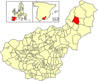
Castilléjar is a municipality located in the province of Granada, Spain. It lies near the confluence of the Rio Galera and the Rio Guardal, approximately at the geographic centre of the Altiplano de Granada. According to the 2006 census (INE), the town has a population of 1619 inhabitants.

Los Navalmorales is a municipality located in the province of Toledo, Castile-La Mancha, Spain. According to the 2006 census (INE), the municipality has a population of 2636 inhabitants.

Petrykivka is an urban-type settlement in Dnipro Raion, Dnipropetrovsk Oblast (province) in east-central Ukraine. It hosts the administration of Petrykivka settlement hromada, one of the hromadas of Ukraine. Population: 4,512 . Petrykivka is famous as a folk art centre and for its unique style of decorative painting.
Zigla-Koulpele is a town in the Garango Department of Boulgou Province in south-eastern Burkina Faso. As of 2005, the town has a population of 4,476.

Hof Ashkelon Regional Council is a regional council in the Southern District of Israel.
Boko is a town in the Niangoloko Department of Comoé Province in south-western Burkina Faso. The town has a population of 2,633.

Arabdzhabirli Vtoroye is a village in the Goychay Rayon of Azerbaijan. The village forms part of the municipality of Ərəbcəbirli.

Şamlıq is a village in the Tovuz Rayon of Azerbaijan. The village forms part of the municipality of Böyük Qışlaq.

Shakhsevan Tretye is a village in the Beylagan Rayon of Azerbaijan.

Nowosiółki Dydyńskie is a village in the administrative district of Gmina Fredropol, within Przemyśl County, Subcarpathian Voivodeship, in south-eastern Poland, close to the border with Ukraine. It lies approximately 8 kilometres (5 mi) south of Fredropol, 18 km (11 mi) south of Przemyśl, and 68 km (42 mi) south-east of the regional capital Rzeszów.
This is a list of the extreme points and extreme elevations in Scotland.

Baszyny is a village in the administrative district of Gmina Krotoszyn, within Krotoszyn County, Greater Poland Voivodeship, in west-central Poland. It lies approximately 15 kilometres (9 mi) east of Krotoszyn and 91 km (57 mi) south-east of the regional capital Poznań.

Trzesieka is a village in the administrative district of Gmina Szczecinek, within Szczecinek County, West Pomeranian Voivodeship, in north-western Poland.
Moider Glacier is a glacier flowing west into the east side of Dalgliesh Bay, Pourquoi Pas Island, in Marguerite Bay, Antarctica. It was named by the UK Antarctic Place-Names Committee in 1979 in association with nearby Perplex Ridge; the word "moider" can be a synonym for "perplex".
El Foûâra is a municipality in the Chouf District of the state of the Mont-Liban, Lebanon.
This page is based on this
Wikipedia article Text is available under the
CC BY-SA 4.0 license; additional terms may apply.
Images, videos and audio are available under their respective licenses.


