Red Rock Dam (Iowa)

Last updated
Red Rock Dam
USACE Red Rock Dam and Lake.jpg
(Army Corps of Engineers)
Official nameRed Rock Dam
Location Marion County, Iowa, United States
Coordinates 41°22′21″N92°58′51″W / 41.37250°N 92.98083°W / 41.37250; -92.98083 Coordinates: 41°22′21″N92°58′51″W / 41.37250°N 92.98083°W / 41.37250; -92.98083
Construction began1960
Opening date1969
Construction cost$88,000,000
Operator(s) US Army Corps of Engineers, Rock Island District
Dam and spillways
Impounds Des Moines River
Height110 ft (34 m)
Length5,676 ft (1,730 m)
Width (base)13.4 ft (4 m) (concrete base)
Reservoir
Creates Lake Red Rock
Total capacity114,400 cubic feet (= max outflow)
Catchment area 12,320 square miles
Surface area15,250 acres (61.7 km2)
Website
U.S. Army Corps of Engineers, Lake Red Rock Project

Red Rock Dam is a dam in central Iowa, United States, on the Des Moines River, forming Lake Red Rock. It is contained entirely within Marion County. The nearest cities are Pella to the northeast, and Knoxville to the southwest.

Contents

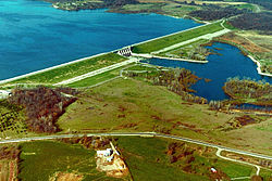
The dam consists of a rolled earthfill embankment and a gravity concrete control section. The dam, at crest elevation of 797 feet (243 m) above mean sea level, is about 5,200 feet (1,600 m) long and 95 feet (29 m) high above the flood plain. A compacted impervious cutoff trench to bedrock and a grout curtain in the rock are provided for underseepage control. [1]

It was constructed along with Saylorville Dam as a flood control project by the US Army Corps of Engineers, Rock Island District. Major flooding occurred in 1851, 1859, 1903, 1944, 1947, and 1954. [2] In 1960, the Corps began construction. The project was completed in 1969 at a cost of $88 million. The Army Corps maintains its local offices in Knoxville.

In 2014, work started to retrofit the dam to provide hydro-electric power. At a capacity of 36.4 MW it is estimated that annual energy produced by the project will be 178,000 MWh, or enough to power approximately 18,000 homes. The primary purpose of the dam will remain to manage flood control. [3]

Extensive recreational development along the lakeshore rapidly followed.

It was a key location in the 1972 movie A Thief in the Night and its 1978 sequel A Distant Thunder. Lake Red Rock was named after one of the lost towns under the reservoir, Red Rock.

The dam was supposed to take 3 years to fill but it was filled in 5 days to max capacity due to the prevented flood of 1969.

See also

Related Research Articles

<span class="mw-page-title-main">Mississippi River</span> Major river in the United States

The Mississippi River is the second-longest river and chief river of the second-largest drainage system in North America, second only to the Hudson Bay drainage system. From its traditional source of Lake Itasca in northern Minnesota, it flows generally south for 2,340 miles (3,770 km) to the Mississippi River Delta in the Gulf of Mexico. With its many tributaries, the Mississippi's watershed drains all or parts of 32 U.S. states and two Canadian provinces between the Rocky and Appalachian mountains. The main stem is entirely within the United States; the total drainage basin is 1,151,000 sq mi (2,980,000 km2), of which only about one percent is in Canada. The Mississippi ranks as the thirteenth-largest river by discharge in the world. The river either borders or passes through the states of Minnesota, Wisconsin, Iowa, Illinois, Missouri, Kentucky, Tennessee, Arkansas, Mississippi, and Louisiana.

Ledges State Park

Ledges State Park is a state park of Iowa, USA, located approximately four miles (6.4 km) south of the city of Boone. The park contains a sandstone gorge carved by Pea's Creek, a tributary of the Des Moines River. The gorge is 100 feet (30 m) deep in places, with concretions jutting from the cliffs.

McNary Dam Dam in Oregon, USA

McNary Dam is a 1.4-mile (2.2-km) long concrete gravity run-of-the-river dam which spans the Columbia River. It joins Umatilla County, Oregon with Benton County, Washington, 292 miles (470 km) upriver from the mouth of the Columbia. It is operated by the U.S. Army Corps of Engineers' McNary Lock and Dam office. The dam is located a mile (2 km) east of the town of Umatilla, Oregon, and 8 miles (13 km) north of Hermiston, Oregon. The dam was originally planned to be named Umatilla Dam, but the Flood Control Act of 1945 renamed the dam in honor of Senator Charles L. McNary of Oregon, who had died the previous year.

Lake Allatoona Body of water

Lake Allatoona is a U.S. Army Corps of Engineers reservoir on the Etowah River in northwestern part of the State of Georgia. This reservoir is mostly in southeastern Bartow County and southwestern Cherokee County. A small portion is located in Cobb County near Acworth.

Table Rock Lake Man-made lake in Missouri and Arkansas, United States

Table Rock Lake is an artificial lake or reservoir in the Ozarks of southwestern Missouri and northwestern Arkansas in the United States. Designed, built and operated by the U.S. Army Corps of Engineers, the lake is impounded by Table Rock Dam, which was constructed from 1954 to 1958 on the White River.

Raystown Lake Man-made lake in Pennsylvania, United States

Raystown Lake is a reservoir in Huntingdon County, Pennsylvania. It is the largest lake that is entirely within Pennsylvania. The original lake was built by the Simpson family of Huntingdon as a hydroelectric project. The current 8,300-acre (34 km2) Raystown Lake was completed in 1973 by the Army Corps of Engineers. Raystown is around 200 feet (61 m) deep in the deepest area near the dam. The lake was created primarily to control floods, provide electricity, and support recreational activities. Allegheny Electric Cooperative operates the Raystown Hydroelectric Project and William F. Matson Generating Station at the Raystown Dam, a 21 MW, two-unit hydroelectric project.

Dworshak Dam Dam in Idaho

Dworshak Dam is a concrete gravity dam in the western United States, on the North Fork Clearwater River in Clearwater County, Idaho. The dam is located approximately four miles (6 km) northwest of Orofino and impounds the Dworshak Reservoir for flood control and hydroelectricity generation. With a height of 717 feet (219 m), Dworshak is the third tallest dam in the United States and the tallest straight-axis concrete dam in the Western Hemisphere. Lacking fish ladders, Dworshak Dam blocks fish passage and completely extirpated anadromous fish migration into the upper reaches of the North Fork Clearwater River and its tributaries in Idaho. Construction of the dam by the U.S. Army Corps of Engineers (USACE) began in 1966 and was completed in 1973.

Saylorville Lake Body of water

Saylorville Lake is a reservoir on the Des Moines River in Iowa, United States. It is located 11 miles (18 km) upstream from the city of Des Moines, and 214 miles (344 km) from the mouth of the Des Moines River at the Mississippi River. It was constructed as part of a flood control system for the Des Moines River as well as to aid in controlling flood crests on the Mississippi, of which the Des Moines is a tributary. The lake and dam is owned and operated by the U.S. Army Corps of Engineers, Rock Island District.

Isabella Dam is an embankment dam located in the Kern River Valley, about halfway down the Kern River course, between the towns of Kernville and Lake Isabella in Kern County, California.

Summersville Lake Dam and Lake in Nicholas County, West Virginia

Summersville Lake is a reservoir located in the US state of West Virginia. The lake is formed by a rock-fill dam on the Gauley River, south of Summersville in Nicholas County. It is the largest lake in West Virginia, with 2,700 acres (1,100 ha) of water and over 60 miles (97 km) of shoreline at the summer pool water level. Its maximum depth is 327 feet.

Lake Red Rock (Des Moines River) Body of water

Lake Red Rock, also referred to as Red Rock Reservoir is a reservoir formed by Red Rock Dam on the Des Moines River, about 41 miles southeast of the city of Des Moines, Iowa, U.S. The dam was completed in 1969 as a Flood control project by the United States Army Corps of Engineers, creating the largest lake in Iowa. The lake is essentially confined to Marion County. The damface is a few miles west and south of Pella, and similarly, a few miles northeast of Knoxville.

Grapevine Lake Reservoir in Texas, United States

Grapevine Lake is an American reservoir located in the North Texas region, approximately 20 mi (32 km) northwest of Dallas and northeast of Fort Worth. It was impounded in 1952 by the US Army Corps of Engineers when they dammed Denton Creek, a tributary of Trinity River.

Lake O the Pines Body of water

Lake O’ the Pines is a reservoir on Big Cypress Bayou, also known as Big Cypress Creek, chiefly in Marion County, Texas, USA. The reservoir also occupies a small part of Upshur and Morris Counties. The dam is located approximately 8.5 miles (13.7 km) west of Jefferson.

Coralville Lake Body of water

Coralville Lake is an artificial lake in Johnson County, Iowa, United States, formed by the Coralville Dam, a dam built from 1949 to 1958 on the Iowa River upstream from the city of Coralville, Iowa.

John Redmond Reservoir Body of water

John Redmond Reservoir is a reservoir on the Neosho River in eastern Kansas. Built and managed by the U.S. Army Corps of Engineers, it is used for flood control, recreation, water supply, and wildlife management. It borders the Flint Hills National Wildlife Refuge to the northwest.

Delhi Dam Dam in near Delhi, Iowa

Delhi Dam, also known as Hartwick Dam, was an embankment dam on the Maquoketa River 2.5 km southwest of Delhi, Iowa that created Lake Delhi. The dam was over-topped and subsequently failed on July 24, 2010 after a period of heavy rain.

Kanopolis Lake Body of water

Kanopolis Lake is a reservoir in Ellsworth County in the Smoky Hills of central Kansas, about 31 miles southwest of Salina and a few miles southeast of the town of Kanopolis. The lake is formed by Kanopolis Dam. Completed in 1948 as a flood control and water conservation project of the United States Army Corps of Engineers, the dam impounds the Smoky Hill River.

Council Grove Lake Body of water

Council Grove Lake is a reservoir on the Neosho River in east-central Kansas. Built and managed by the U.S. Army Corps of Engineers, it is used for flood control, recreation, and water supply.

Abiquiu Dam Dam in Rio Arriba County, New Mexico

Abiquiu Dam is a dam on the Rio Chama, located about 60 miles (97 km) northwest of Santa Fe in Rio Arriba County, New Mexico. Built and operated by the U.S. Army Corps of Engineers (USACE), the dam is an earth embankment structure 354 feet (108 m) high and 1,800 feet (550 m) long, containing 11.8 million cubic yards of fill. The dam forms Abiquiu Lake, one of the largest lakes in New Mexico with a full storage capacity of 1,369,000 acre-feet (1,689,000 dam3) and 5,200 acres (2,100 ha) of water. To date, the reservoir has never filled to capacity, with a record high of 402,258 acre-feet (496,178 dam3), 29.4% of full pool, on June 22, 1987. The dam's primary purpose is flood control, in addition to irrigation and municipal water storage, and hydroelectric generation.

References

  1. Article title
  2. "Red Rock Flood Damage Reduction". www.mvr.usace.army.mil. Archived from the original on 2002-01-31.
  3. http://redrockhydroproject.com/