
Cabot Strait is in Atlantic Canada between Cape Ray, Newfoundland, and Cape North, Cape Breton Island. The strait, approximately 110 kilometres wide, is the widest of the three outlets for the Gulf of Saint Lawrence into the Atlantic Ocean, the others being the Strait of Belle Isle and Strait of Canso. It is named for the Italian explorer Giovanni Caboto.
Division No. 1, Subdivision A is an unorganized subdivision on the Avalon Peninsula in Newfoundland and Labrador, Canada. It is in Division No. 1, and lies between Trinity Bay and Placentia Bay.

Avalon is a federal electoral district on Newfoundland Island in Newfoundland and Labrador, Canada. It has been represented in the House of Commons of Canada since 2004.

Cape Spear is a headland located on the Avalon Peninsula of Newfoundland near St. John's in the Canadian province of Newfoundland and Labrador. At a longitude of 52°37' W, it is the easternmost point in Canada and North America, excluding Greenland.

Cape Race is a point of land located at the southeastern tip of the Avalon Peninsula on the island of Newfoundland, in Newfoundland and Labrador, Canada. Its name is thought to come from the original Portuguese name for this cape, "Raso", meaning flat or low-lying. The Cape appeared on early sixteenth century maps as Cabo Raso and its name may derive from a cape of the same name at the mouth of the Tagus River in Portugal. The cape was the location of the Cape Race LORAN-C transmitter until the system was decommissioned in 2010. It is also home to the Cape Race Lighthouse, notable for having received the distress call from the RMS Titanic.
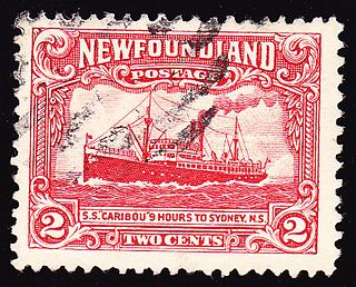
SS Caribou was a Newfoundland Railway passenger ferry that ran between Port aux Basques, in the Dominion of Newfoundland, and North Sydney, Nova Scotia between 1928 and 1942. During the Battle of the St. Lawrence the ferry participated in thrice-weekly convoys between Nova Scotia and Newfoundland. A German submarine attacked the convoy on 14 October 1942 and Caribou was sunk. She had women and children on board, and many of them were among the 137 who died. Her sinking, and large death toll, made it clear that the war had really arrived on Canada's and Newfoundland's home front. Her sinking is cited by many historians as the most significant sinking in Canadian-controlled waters during the Second World War.
Cap Fréhel is a peninsula in Côtes-d'Armor, in northern Brittany, France which extends off the Côte d'Émeraude into the Golfe de Saint-Malo. No towns or villages are situated on the peninsula; however, two lighthouses, one from the 17th century and the other one from 1950, are located at the tip of it. The Cap is located 8.5 km from the town centre of Fréhel, although, administratively, it is located within the territory of the commune of Plévenon.

Cape Ray is a headland located at the southwestern extremity of the island of Newfoundland in the Canadian province of Newfoundland and Labrador.
Cape Ray is a local service district and designated place in the Canadian province of Newfoundland and Labrador. It is on the southwest coast of the island of Newfoundland.
St. Bride's is a town on the Cape Shore of Newfoundland, Canada. Located 166 km Southwest of the capital of Newfoundland and Labrador, St. John's, St. Bride's is a fishing community with a population of approximately 318 persons as of 2021. The largest codfish ever caught, weighing in at 125 lbs, was landed here in 1905.

Cape Anguille is a settlement in the south-west region of Newfoundland, Canada. It marks the south-western edge of the Anguille Mountains. The Cape Anguille Lighthouse is located in Cape Anguille.

Cape Anguille is a headland and the westernmost point in Newfoundland, reaching into the Gulf of Saint Lawrence. It is the southern edge of St. George's Bay. Its name is derived from the French word anguille, which means eel. Close to the cape is the community of Cape Anguille.
Cape St. George is a headland and community of the same name, located at the southwestern tip of the Port au Port Peninsula on the Canadian island of Newfoundland.
Island Harbour is a designated place in the Canadian province of Newfoundland and Labrador.
Trans Canada Microwave or Trans-Canada Skyway was a microwave relay system built in the 1950s to carry telephone and television signals from Canada's east coast to its west coast. Built across the nation, the towers ranged in height from nine metres high, to one in northern Ontario that was over 100 metres high. The system included 139 towers spanning over 6,275 kilometres and cost $50 million.
South Branch is a settlement located on the west coast of the island of Newfoundland in the province of Newfoundland and Labrador, Canada. South Branch is one of fifteen communities within the greater Codroy Valley area and is located alongside the Trans-Canada Highway between Channel-Port aux Basques and St. George's Bay.
Great Codroy is a local service district and designated place in the Canadian province of Newfoundland and Labrador. In 2016, it had a population of 69.

Division No. 1, Subdivision G is an unorganized subdivision on the Avalon Peninsula in Newfoundland and Labrador, Canada. It is in Division 1 and contains the unincorporated communities of Baccalieu Island, Besom Cove, Bradley's Cove, Burnt Point, Caplin Cove, Daniel's Cove, Grates Cove, Gull Island, Job's Cove, Kingston, Long Beach, Lower Island Cove, Low Point, Northern Bay, Ochre Pit Cove, Red Head Cove, Riverhead, Smooth Cove and Western Bay.
Division No. 1, Subdivision U is an unorganized subdivision on the Avalon Peninsula in Newfoundland and Labrador, Canada, in Division 1. It contains the unincorporated communities of Admiral's Cove, Bauline East, Bauline South, Burnt Cove, Devils Kitchen, Flat Rock, St. Michaels and Seal Cove.