Redington Pass

Last updated
Redington Pass
Elevation 1,310 m (4,298 ft)
Location (eastern)-Sonoran Desert
Madrean Sky Islands
Pima County, Arizona, United States
Range Santa Catalina Mountains-N & NW
Rincon Mountains-S
Coordinates 32°18′27″N110°36′00″W / 32.3075°N 110.6°W / 32.3075; -110.6

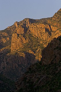
Redington Pass (el. 1310 m./4300 ft.) is a high mountain pass between the Santa Catalina Mountains and the Rincons in northeast Pima County, Arizona. It is located just east of Tucson. Historically, it was the connection between the farming and ranching areas of Redington along the San Pedro River on the east side of the pass and Tucson on the west side.

Mountain pass Route through a mountain range or over a ridge

A mountain pass is a navigable route through a mountain range or over a ridge. Since many of the world's mountain ranges have presented formidable barriers to travel, passes have played a key role in trade, war, and both human and animal migration throughout Earth's history. At lower elevations it may be called a hill pass. The highest vehicle-accessible pass in the world appears to be Mana Pass, located in the Himalayas on the border between India and Tibet, China.

Santa Catalina Mountains mountain range

The Santa Catalina Mountains, commonly referred to as the Catalina Mountains or the Catalinas, are north and northeast of Tucson in Arizona, United States, on Tucson's north perimeter. The mountain range is the most prominent in the Tucson area, with the highest average elevation. The highest point in the Catalinas is Mount Lemmon at an elevation of 9,157 feet (2,791 m) above sea level and receives 180 inches (460 cm) of snow annually.

Rincon Mountains

The Rincon Mountains are a significant mountain range east of Tucson, Pima County, Arizona, in the United States. The Rincon Mountains are one of five mountain ranges surrounding the Tucson valley. The other ranges include the most prominent, the Santa Catalina Mountains to the north, the Santa Rita Mountains to the south, the Tucson Mountains to the west, and the Tortolita Mountains to the northwest. Redington Pass separates the Rincon Mountains from the Santa Catalina Mountains. The Rincon Mountains are generally less rugged than the Santa Catalina Mountains and Santa Rita Mountains. The Rincon Mountains are also included in the Madrean sky island mountain ranges of southeast Arizona, extreme southwest New Mexico, and northern Sonora Mexico.

The road through Redington Pass is unpaved and the area throughout the pass is a favorite of mountain bikers and all-terrain vehicle riders. The area was also frequented by firearms enthusiasts, as the region contained three unofficial shooting range areas. As of 2013 these unofficial shooting ranges have been shut down [1] by federal officials due to litter and noise pollution. [2] The west side of the pass near Tanque Verde Falls affords views overlooking the east side of the city of Tucson, spread out across the Sonoran Desert floor below.

Tanque Verde Falls are a series of waterfalls in Tanque Verde Canyon east of Tanque Verde, Arizona and Tucson, Arizona. Tanque Verde Ridge of the Rincon Mountains lies to the south and Agua Caleinte Hill to the north. The falls lie south of Redington Road which connects the Tucson Valley to the southwest with the San Pedro River valley to the east.

Sonoran Desert North American desert

The Sonoran Desert is a North American desert which covers large parts of the Southwestern United States in Arizona and California and of Northwestern Mexico in Sonora, Baja California, and Baja California Sur. It is the hottest desert in Mexico. It has an area of 260,000 square kilometers (100,000 sq mi). The western portion of the United States–Mexico border passes through the Sonoran Desert.

Related Research Articles

Tucson, Arizona City in Arizona, United States

Tucson is a city and the county seat of Pima County, Arizona, United States, and home to the University of Arizona. The 2010 United States Census put the population at 520,116, while the 2015 estimated population of the entire Tucson metropolitan statistical area (MSA) was 980,263. The Tucson MSA forms part of the larger Tucson-Nogales combined statistical area (CSA), with a total population of 1,010,025 as of the 2010 Census. Tucson is the second-largest populated city in Arizona behind Phoenix, both of which anchor the Arizona Sun Corridor. The city is 108 miles (174 km) southeast of Phoenix and 60 mi (97 km) north of the U.S.–Mexico border. Tucson is the 33rd largest city and the 58th largest metropolitan area in the United States (2014).

Catalina Foothills, Arizona CDP in Arizona, United States

Catalina Foothills is a census-designated place (CDP) located north of Tucson in Pima County, Arizona, United States. Situated in the southern foothills of the Santa Catalina Mountains, Catalina Foothills had a population of 50,796 at the 2010 census. Catalina Foothills is one of the most affluent communities in Arizona and in the U.S., with the 6th highest per capita income in Arizona, and the 14th highest per capita income in the U.S. of communities with a population of at least 50,000. The Catalina Foothills community includes some of Arizona's most expensive homes and land, and has the highest median property value. It boasts some of the nation's most prestigious resorts, golf courses, and spas.

Tanque Verde, Arizona CDP in Arizona, United States

Tanque Verde is a suburban census-designated place (CDP) in Pima County, Arizona, United States, northeast of Tucson. The population was 16,195 at the 2000 census.

Avra Valley valley in Arizona, United States of America

The Avra Valley is a 50-mile (80 km) long northwest-southeast valley, bordering the west of Tucson, Arizona. The Tucson Mountains are at the valley's center-east, with suburbs ranging east of the Tucson Mountains and trending northwest to the Avra Valley's northeast. This entire northwest stretch from Tucson contains the northwest trending Interstate 10, the route to Casa Grande and Phoenix. The northeast of the valley contains Marana on I-10, the Pinal Airpark, an aircraft storage park, and other communities along I-10. Avra Valley Airport is a general aviation airport in Marana, located about 15 miles northwest of Tucson and being used for storage of classic propeller-era airliners.

Sentinel Peak (Arizona) mountain in Arizona, United States of America

Sentinel Peak is a 2,897 ft peak in the Tucson Mountains southwest of downtown Tucson, Arizona. The valley's first inhabitants grew crops at the mountain's base, along the Santa Cruz River. The name "Tucson" is derived from the O'odham Cuk Ṣon[tʃʊk ʂɔːn], meaning "[at the] base of the black [hill]". In the 1910s, University of Arizona students used local basalt rock to construct a 160-ft-tall block "A" on the mountain's east face, near its summit, giving the peak its other name, "A" Mountain. The peak is part of a 272-acre park, the largest natural resource park in the City of Tucson.

Apache Pass

Apache Pass, also known by its earlier Spanish name Puerto del Dado, is a historic mountain pass in the U.S. state of Arizona between the Dos Cabezas Mountains and Chiricahua Mountains at an elevation of 5,110 feet (1,560 m). It is approximately 20 miles (32 km) east-southeast of Willcox, Arizona, in Cochise County.

Tres Alamos, Arizona Ghost town in Arizona, United States

Tres Alamos is a ghost town in Cochise County in the U.S. state of Arizona. The town was settled in 1874 in what was then the Arizona Territory.

Camp Grant massacre

The Camp Grant massacre, on April 30, 1871, was an attack on Pinal and Aravaipa Apaches who surrendered to the United States Army at Camp Grant, Arizona, along the San Pedro River. The massacre led to a series of battles and campaigns fought between the Americans, the Apache, and their Yavapai allies, which continued into 1875, the most notable being General George Crook's Tonto Basin Campaign of 1872 and 1873.

Redington, Arizona Populated place in Arizona, United States

Redington is a populated place in Pima County, Arizona, United States.

Desert Palms Park human settlement in Tucson, Arizona, United States of America

Desert Palms Park (DPP) is a neighborhood in Tucson, Arizona. It is located in the east side of the city, between 8900-9100 east and 1300-1800 north. It is bordered by Speedway Boulevard to the South and Wrightstown Road to the North. The Catalina Mountains can be seen to the north and the Rincon Mountains to the east.

Huachuca Mountains

The Huachuca Mountain range is part of the Sierra Vista Ranger District of the Coronado National Forest. The Huachuca Mountains are located in Cochise County, Arizona approximately 70 miles (110 km) south-southeast of Tucson and southwest of the city of Sierra Vista, Arizona. Included in this area is the highest peak in the Huachucas, Miller Peak, and the region of the Huachucas known as Canelo Hills in eastern Santa Cruz County. The mountains range in elevation from 3,934 feet (1,199 m) at the base to 9,466 feet (2,885 m) at the top of Miller Peak. The second highest peak in this range is Carr Peak, elevation 9,200 feet (2,804 m). The Huachuca Mountain area is owned principally by the USDA Forest Service (41%), the U.S. Army (20%), and private land (32%). Sierra Vista is the main population center.

Traditional Arizona

Prior to the adoption of its name for a U.S. state, Arizona was traditionally defined as the region south of the Gila River to the present-day Mexican border, and between the Colorado River and the Rio Grande. It encompasses present-day Southern Arizona and the New Mexico Bootheel plus adjacent parts of Southwestern New Mexico. This area was transferred from Mexico to the United States in the Gadsden Purchase of 1853. Mining and ranching were the primary occupations of traditional Arizona's inhabitants, though growing citrus fruits had long been occurring in Tucson.

Capture of Tucson (1862)

Union forces entered Tucson on May 20, 1862, with a force of 2,000 men without firing a shot.

Little Rincon Mountains

The Little Rincon Mountains are a small range of mountains, lying to the east of the Rincon Mountains, at Tucson, of eastern Pima County, Arizona. The range is located in northwest Cochise County and is part of the western border of the San Pedro River and Valley, the major valley and river of western Cochise County. The river is northward flowing to meet the Gila River; its headwaters are south of the US-Mexico border in northern Sonora. A small part of the Little Rincon range's southwest lies in Pima County.

Con-Nichiwa is an annual anime convention held during April at the Tucson Convention Center in Tucson, Arizona.

Mission San Cosme y Damián de Tucsón

Mission San Cosme y Damián de Tucsón, originally known as Mission de San Agustin del Tucson. It was located on the west side of the Santa Cruz River, at the base of Sentinel Peak or "A" Mountain in present-day Tucson, Pima County, Arizona.

Tres Alamos Wash, an ephemeral stream tributary to the San Pedro River, in Cochise County, Arizona. It runs southwesterly to meet the San Pedro River, across the river from the former settlement of Tres Alamos, Arizona. Tres Alamos Wash passes east and northeastward between the Little Dragoon Mountains and Johnny Lyon Hills to where it arises in a valley east of those heights and west of Allen Flat and the Steele Hills. It has its source at 32°07′45″N110°02′59″W.

References

  1. Kreutz, Doug (14 January 2013). "Trashed Redington areas will be fenced off, cleaned". Arizona Daily Star. Retrieved 6 March 2013.
  2. Duggan, Mark (24 December 2012). "Forest Service Focuses on Redington Pass". Arizona Public Media. Retrieved 6 March 2013.


Coordinates: 32°18′27″N110°36′00″W / 32.3075°N 110.6°W / 32.3075; -110.6

Geographic coordinate system Coordinate system

A geographic coordinate system is a coordinate system that enables every location on Earth to be specified by a set of numbers, letters or symbols. The coordinates are often chosen such that one of the numbers represents a vertical position and two or three of the numbers represent a horizontal position; alternatively, a geographic position may be expressed in a combined three-dimensional Cartesian vector. A common choice of coordinates is latitude, longitude and elevation. To specify a location on a plane requires a map projection.