Redscar Bay

Last updated

Redscar Bay is a bay to the northwest of Port Moresby, Papua New Guinea, extending for about 4 miles (6.4 km) between Cape Suckling and Redscar Head, [1] also situated between Kekeni Rocks and Lagava Island.

Port Moresby Place in National Capital District, Papua New Guinea

Port Moresby, also referred to as Pom City or simply Moresby, is the capital and largest city of Papua New Guinea and the largest city in the South Pacific outside of Australia and New Zealand. It is located on the shores of the Gulf of Papua, on the south-western coast of the Papuan Peninsula of the island of New Guinea. The city emerged as a trade centre in the second half of the 19th century. During World War II it was a prime objective for conquest by the Imperial Japanese forces during 1942–43 as a staging point and air base to cut off Australia from Southeast Asia and the Americas.

Papua New Guinea constitutional monarchy in Oceania

Papua New Guinea, officially the Independent State of Papua New Guinea is a country in Oceania that occupies the eastern half of the island of New Guinea and its offshore islands in Melanesia, a region of the southwestern Pacific Ocean north of Australia. Its capital, located along its southeastern coast, is Port Moresby. The western half of New Guinea forms the Indonesian provinces of Papua and West Papua.

Contents

Geography

A significant number of rivers and streams flow into the bay, including the Vanapa, Veimauri, and Aroa rivers, and to the northeast is Varivari Island. There is a head of the same name on the coast, a prominent rock which is red in color. [2] Galley Reach, a relatively wide inlet which extends through the bar across the estuary of the bay, is considered a hazard to boats. [3] The Pariwara Islets, two small islets with some rocks, lie 1–2 miles northwestward of Redscar Head, and Redscar Hill rises above the head to a height of 575 feet (175 m). [4] Between Cape Suckling and Redscar there is a coral reef extending 0.5 to 1 mile offshore. [3] The shoreline is low and swampy, with dense woodland. [3]

The Vanapa is a river of Papua New Guinea. It flows into Galley Reach of Redscar Bay to the north-west of Port Moresby.

The Veimauri is a river of Papua New Guinea. It flows into Galley Reach of Redscar Bay to the north-west of Port Moresby. To the east of the mouth there are rubber and coconut plantations on the banks and the Veimauri River Bridge. The river area is protected under the Veimauri River Forest Reserve, which has a significant population of parrots.

The Aroa is a river of Papua New Guinea. It flows into the sea in the northern end of Redscar Bay, about 11 miles from Cape Suckling, to the north-west of Port Moresby. 1.75 metres to the south are the Kekeni Rocks, reaching a height of 21 metres (69 ft)

History and archaeology

Sir Peter Scratchley's Camp near the bank of the Aroa and Redscar Bay in 1885 Picturesque New Guinea Plate XVI - Sir Peter Scratchley's Camp.jpg
Sir Peter Scratchley's Camp near the bank of the Aroa and Redscar Bay in 1885

Gold was first discovered in Papua New Guinea in 1852 as accidental traces in pottery from Redscar Bay on the Papua Peninsula. Since, numerous items have been discovered in the bay area, and the British Museum is in possession of 44 items, mainly arrows, and spears, an adze, a cooking pot, a necklace, a skirt, and a paddle. [5] Sir Peter Scratchley led an expedition to the area in 1885. The Rogers Airfield was located near the bay and several planes crashed nearby during World War II, including P-39D Airacobra 41-6945, P-39F Airacobra 41-7136, B-25H Mitchell 43-4341, P-47D Thunderbolt, and P-47D "Hi Topper" 42-8081. [2]

British Museum National museum in the Bloomsbury area of London

The British Museum, in the Bloomsbury area of London, United Kingdom, is a public institution dedicated to human history, art and culture. Its permanent collection of some eight million works is among the largest and most comprehensive in existence, having been widely sourced during the era of the British Empire. It documents the story of human culture from its beginnings to the present. It was the first public national museum in the world.

Peter Scratchley british Army officer

Major General Sir Peter Henry Scratchley was special commissioner for Great Britain in New Guinea 1884–1885 and defence adviser for Australia.

Rogers Airfield former World War II airfield near Port Moresby, Papua New Guinea

Rogers Airfield is a former World War II airfield near Redscar Bay, Papua New Guinea. It was part of a multiple-airfield complex in the Port Moresby area, located 30 miles (48 km) north-west of Port Moresby by air, near Rorona.

Demographics

The Kabadi or Motu languages are spoken in the bay area. [6]

Motu is one of many Central Papuan Tip languages and is spoken by the Motuans, native inhabitants of Papua New Guinea. It is commonly used today in the region, particularly around the capital, Port Moresby.

Related Research Articles

Queensland is the second largest state in Australia. It contains 472 separate protected areas with a total land area of 69,388 km2 (26,791 sq mi). 223 of these are National parks, which is the highest number of any Australian state or territory, totalling 65,871 km2 (25,433 sq mi). Seven others are Scientific National Parks, totalling 522 km2 (202 sq mi).

Protected areas of Tasmania consists of protected areas located within Tasmania and its immediate onshore waters, including Macquarie Island. It includes areas of crown land managed by Tasmanian Government agencies as well as private reserves. As of 2016, 51% of Tasmania's land area has some form of reservation classification, the majority is managed by the Tasmania Parks & Wildlife Service. Marine protected areas cover about 7.9% of state waters.

Flinders Chase National Park Protected area in South Australia

Flinders Chase National Park is a protected area in the Australian state of South Australia located at the west end of Kangaroo Island about 177 kilometres west-south west of the state capital of Adelaide and 110 kilometres west of the municipal seat of Kingscote. It is a sanctuary for endangered species and home to a few geological phenomena. It was the second national park to be declared in South Australia.

Territorial waters Coastal waters that are part of a nation-states sovereign territory

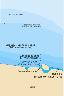
The term territorial waters is sometimes used informally to refer to any area of water over which a state has jurisdiction, including internal waters, the territorial sea, the contiguous zone, the exclusive economic zone and potentially the continental shelf. In a narrower sense, the term is used as a synonym for the territorial sea.

Rossel Island island in Papua New Guinea

Rossel Island is the easternmost island of the Louisiade Archipelago, which itself is part of the Milne Bay Province of Papua New Guinea. Tree Islet is situated 1.5 miles (2.4 km) to the north-west, while Wule Island is situated 1.5 miles (2.4 km) westward.

Janszoon voyage of 1605–06

Willem Janszoon made the first recorded European landing on the Australian continent in 1606, sailing from Bantam, Java, in the Duyfken. As an employee of the Dutch East India Company, Janszoon had been instructed to explore the coast of New Guinea in search of economic opportunities. He had originally arrived in Dutch East Indies from the Netherlands in 1598 and became an officer of the VOC on its establishment in 1602.

Mount Suckling mountain in Papua New Guinea

Mount Suckling or Goropi, is the highest peak of the Goropu Mountains, part of the Owen Stanley Range in south-eastern Papua New Guinea. It lies about 250 kilometres (160 mi) east of Port Moresby. Situated on a relatively narrow peninsula, it lies only about 60 km (40 mi) from the sea to both the north-east and the south. While not the highest peak in the Owen Stanley Range, it is the most topographically prominent peak in the range, and it is in fact the third most prominent peak on the island of New Guinea. The peak rises above the timberline, while its lower slopes are well-forested.

Namonuito Atoll island group

Namonuito Atoll, also called Namonweito, Weito, or Magur Islands, is the largest atoll of the Federated States of Micronesia and of the Caroline Islands with a total area of 2,267 square kilometres, unless one considers the still larger Chuuk (Truk) Lagoon as a type of atoll in an early stage of development. In Micronesia, only Kwajalein Atoll of the Marshall Islands is still larger.

Pocklington Reef island in Milne Bay Province, Papua New Guinea

Pocklington Reef is a coral reef and a mostly submerged atoll in the far southeast of Papua New Guinea.

Bramble Cay island

Bramble Cay, also called Maizab Kaur, Massaramcoer or Baramaki, and located at the northeastern edge of the Torres Strait Islands of Queensland and at the northern end of the Great Barrier Reef, is the northernmost point of land of Australia. It is 55 kilometres (34 mi) southeast of the mouth of the Fly River of Papua New Guinea.

Parama Island island in Papua New Guinea

Parama Island is an island close off the south coast of Papua New Guinea. It is located 17 km east of Daru, the provincial capital of Western Province, at the southernmost extreme of the Fly River delta, and at the northeastern corner of the Torres Strait. It is the northernmost of the Torres Strait Islands, and at the same time the southernmost of the Fly River delta. Bampton Point, its southernmost point, marks the southwestern corner of the Gulf of Papua. The Coral Sea is southeast. Torres Strait is south and southwest, specifically the Great Northeast Channel, which separates Parama Island from the closest Australian (Queensland) island, Bramble Cay, 48 km ESE.

Papuan Peninsula

The Papuan Peninsula, also known as the Bird's Tail Peninsula, is a large peninsula in Papua New Guinea, southeast of the city of Lae, that makes up the southeastern portion of the island of New Guinea. The peninsula is the easternmost extent of the New Guinea Highlands and consists largely of the Owen Stanley Range, with peaks such as Mount Victoria and Mount Suckling. On the south coast is Port Moresby, the capital and largest city of Papua New Guinea.

Nepean Bay

Nepean Bay is a bay located on the north-east coast of Kangaroo Island in the Australian state of South Australia about 130 kilometres south-south-west of Adelaide. It was named by the British navigator, Matthew Flinders, after Sir Evan Nepean on 21 March 1802.

Fox Islands Passes

The Fox Islands Passes are waterways in the Fox Islands area of the U.S. state of Alaska, connecting the Bering Sea with the North Pacific Ocean.

The Ankamuti were an indigenous Australian people of the Cape York Peninsula of Queensland.

Western Kangaroo Island Marine Park (state waters) Protected area in South Australia

Western Kangaroo Island Marine Park is a marine protected area in the Australian state of South Australia located in the state’s coastal waters adjoining both the west coast of Kangaroo Island and Lipson Reef, an islet located to the south of Kangaroo Island.

References

Coordinates: 9°8′49″S146°50′8″E / 9.14694°S 146.83556°E / -9.14694; 146.83556

Geographic coordinate system Coordinate system

A geographic coordinate system is a coordinate system that enables every location on Earth to be specified by a set of numbers, letters or symbols. The coordinates are often chosen such that one of the numbers represents a vertical position and two or three of the numbers represent a horizontal position; alternatively, a geographic position may be expressed in a combined three-dimensional Cartesian vector. A common choice of coordinates is latitude, longitude and elevation. To specify a location on a plane requires a map projection.