The Broads is a network of mostly navigable rivers and lakes in the English counties of Norfolk and Suffolk. Although the terms "Norfolk Broads" and "Suffolk Broads" are correctly used to identify specific areas within the two counties respectively, the whole area is frequently referred to as the Norfolk Broads.

Reedham is a village and civil parish in the English county of Norfolk and within The Broads. It is on the north bank of the River Yare, 12 miles (19 km) east of the city of Norwich, 8 mi (13 km) south-west of the town of Great Yarmouth and the same distance north-west of the Suffolk town of Lowestoft. The village's name means 'reedy homestead/village' or 'reedy hemmed-in land'.

Berney Arms is a settlement on the north bank of the River Yare, close to Breydon Water in the English county of Norfolk. It is part of the civil parish of Reedham, in the district of Broadland, and lies within The Broads. It comprises a railway station, a windmill, a farmhouse and a pub which closed in late 2015. In 2020, an adjacent property opened as a bistro. The area is not accessible by public road.

Halvergate is a village and civil parish in the English county of Norfolk, north of Reedham, between the Rivers Bure and Yare, within The Broads. To the east of the village is the hamlet of Wickhampton and the Halvergate Marshes, an area of drainage marsh which was the site of the first Environmentally Sensitive Area in the United Kingdom in 1987.

The River Yare is a river in the English county of Norfolk. In its lower reaches it is one of the principal navigable waterways of The Broads and connects with the rest of the network.

The River Chet is a small river in South Norfolk, England, a tributary of the River Yare. It rises in Poringland and flows eastwards through Alpington, Bergh Apton, Thurton and Loddon. At Loddon it passes under the A146 through Loddon Mill and into Loddon Staithe. From this point onwards the river is navigable. It then passes Hardley Flood to the north, a nature reserve part-managed by the Norfolk Wildlife Trust. The river finally joins the River Yare one mile west of Reedham at Hardley Cross, erected in 1676, which marks the ancient boundary between the City of Norwich and the Borough of Great Yarmouth. The total navigable length is some 3½ miles.

Reedham railway station is in the south of Purley in the London Borough of Croydon on the Tattenham Corner line. The local area is residential and the station is near the A23 Brighton Road. It is 15 miles 65 chains (25.4 km) measured from London Charing Cross. The Brighton Main Line is adjacent, but is not served by this station.

Berney Arms railway station is a stop on the Wherry Lines in the East of England, serving the settlement of Berney Arms on the Halvergate Marshes in Norfolk. It is located 15 miles 71 chains (25.6 km) east of Norwich and is the only station on a short stretch of single line between Reedham and Great Yarmouth. The station is managed by Greater Anglia, which also operates all trains serving it.

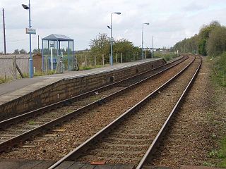
Reedham railway station is a stop on the Wherry Lines in the East of England, serving the village of Reedham, Norfolk. It is 12 miles 13 chains (19.6 km) down the line from Norwich; it is situated between Cantley to the west and, to the east, Berney Arms on the branch to Great Yarmouth or Haddiscoe on the branch to Lowestoft. It is commonly suffixed as Reedham (Norfolk) in order to distinguish it from the station of the same name in south London. Its three-letter station code is REE.

Mid Norfolk is a constituency represented in the House of Commons of the UK Parliament since 2010 by George Freeman, a Conservative.

Brundall Gardens railway station is a stop on the Wherry Lines in the East of England, serving the western side of the village of Brundall, Norfolk. It is sited 4 miles 66 chains (7.8 km) down the line from Norwich on the routes to Great Yarmouth and Lowestoft. Its three-letter station code is BGA. It is managed and served by Greater Anglia.

Haddiscoe railway station is a stop on the Wherry Lines in Norfolk, England. It named after the village of Haddiscoe, some 2 miles (3.2 km) away; however, the village of St Olaves, sited on the other side of the River Waveney, is closer. The station is 16 miles 11 chains (26 km) down the line from Norwich, on the route to Lowestoft; it is situated between Reedham and Somerleyton. Its three-letter station code is HAD.

Wherryman's Way is a long-distance footpath in the English county of Norfolk.

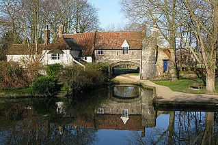
Pulls Ferry is a former ferry house located on the River Wensum in Norwich, Norfolk. It is a flint building and was once a 15th-century watergate. It was the route for the stone used to build Norwich Cathedral. The stone came from Caen up the rivers Yare and Wensum. A canal, specifically built by the monks, used to run under the arch, where the Normans ferried the stone and building materials to be unloaded on the spot.

Berney Arms Windmill is a tower mill located at Berney Arms alongside the River Yare at the south-western end of Breydon Water in the English county of Norfolk. The windmill is in an isolated spot in The Broads around 3.5 miles (5.6 km) north-east of the village of Reedham and 4 miles (6.4 km) south-west of Great Yarmouth. The mill has no road access but can be accessed by boat, by foot or from Berney Arms railway station. It is a scheduled monument under the care of English Heritage.

Maud, along with Albion, is one of only two surviving Norfolk trading wherries to be found on the Norfolk Broads. Maud was built in 1899, and served as a sailing wherry and later as a lighter before being sunk in the mid-1960s as protection for part of the banks of Ranworth Broad. In 1981, she was refloated and taken to Upton where she was restored over a number of years, finally returning to the water in 1999. As of 2010, Maud is active on the Norfolk Broads. She is listed on the register of National Historic Ships in the United Kingdom, as part of the National Historic Fleet.

The Norfolk Railway was an early railway company that controlled a network of 94 miles around Norwich, England. It was formed in 1845 by the amalgamation of the Yarmouth and Norwich Railway opened in 1844, and the Norwich and Brandon Railway, not yet opened. These lines were built out of frustration that the Eastern Counties Railway line that was expected to connect Norwich to London failed to be completed. The Norfolk Railway also leased the Lowestoft Railway and Harbour Company, and built a branch to Dereham and Fakenham, opened in 1846 and 1849 respectively.

Reedham Swing Bridge, on the site of a Victorian swing bridge, is still in use at Reedham, Norfolk, England.

The Reedham Ferry Drainage Mill, also known as The Red Mill is a former drainage windmill found on the River Yare on The Broads in Norfolk. It is now a privately owned holiday home.

Limpenhoe Meadows is a 12-hectare (30-acre) biological Site of Special Scientific Interest west of Reedham in Norfolk. It is part of the Broadland Ramsar site and Special Protection Area, and The Broads Special Area of Conservation.


