Regent Park Revitalization Plan

Last updated

Construction in Toronto's Regent Park Regent Park 001.JPG
Construction in Toronto's Regent Park

The Regent Park Revitalization Plan is an initiative begun in 2005 by the City of Toronto with fellow development, government, and community partners, with a focus on rebuilding the Toronto neighbourhood of Regent Park for 12,500 residents over a 15- to 20-year period. The project entails transforming what was once solely a social housing development into a self-sufficient, mixed-income, multi-use community. [1]

Contents

Background

Phase two included the demolition of the Peter Dickinson tower Peter Dickinson tower at Regent Park being demolished.JPG
Phase two included the demolition of the Peter Dickinson tower

When the community of Regent Park was originally built in 1948, there was limited access to any of Toronto's modes of public transportation. Since the neighbourhood was built to generate a strong sense of community, the area within the neighbourhood was mainly made up of smaller footpaths and small roads – not ideal for transportation and inclusion to the rest of the city. Over time the neighbourhood became isolated and displaced from the adjacent downtown core and grew a reputation as being one of Toronto's poorer, dangerous neighbourhoods. The plan to revitalize Regent Park is an initiative with the goal to alleviate the socio-economic gap that had been created and expanded over the last 60 years. Revitalization is meant to promote a full community upheaval by building community facilities as well as affordable housing and home ownership opportunities. A mixed-income, mixed-use community in Regent Park will presumably provide a positive socio-economic shift in a neighbourhood primarily ignored for decades. The new neighbourhood will consist of a mix of rental and condominium buildings, townhouses as well as commercial space with community facilities, active parks and open spaces.

In 2005, The Daniels Corporation partnered with Toronto Community Housing to re-develop 53 of the 69 acres of Toronto’s Regent Park. Creative agency Bob's Your Uncle was retained to manage the rebranding of the neighbourhood and the branding and marketing of the various buildings that comprised the first three phases of the development.

Currently in phase 3 of construction, Regent Park is beginning to see the physical and social shift towards a well-kept, functioning mixed-use neighbourhood. The revitalization plan is being funded by a public-private partnership including government partners such as the City of Toronto as well as the Daniels Corporation. [2] On 11 September 2012, Gene Jones, the current president and CEO of Toronto Community Housing at the time, presented a proposal for phase three of construction for the Regent Park Revitalization Plan. The phase three proposal which would include the Regent Park Athletic Grounds, which would be paid for through a fundraising campaign with primary support from The MLSE Team Up Foundation. The proposed phase three would also introduce three new city streets to Toronto's downtown core, as well as more than 500 replacement rental social housing units and more than 2,000 market condominiums. New businesses would also be opened along Dundas Street, bringing services to the community and providing employment opportunities for neighbourhood residents. [3]

Goals

The original idea surrounding the revitalization plan was to transform an area of the city that was originally built to be solely a social housing development into a thriving up-and-coming mixed-income neighbourhood sparking a social, economic and cultural revival to the area. The physical transformation includes an implementation of diverse styles of sustainable architecture (a shift from red and gray social housing projects), expanding and reconnecting the road networks to the Toronto Transit Commission as well as new streets and alleys maintained by the city. It also means adding new parks, open space, retail locations, and a new arts complex. According to Toronto Housing, before revitalization there were 7,500 tenants living in 2,083 rent-geared-to-income (RGI) units.

Regent Park by the Numbers

Relocation and return

One of the prominent claims made by Toronto Community Housing from the beginning of the revitalization plan was that all Regent Park residents who have been relocated due to construction are guaranteed a right to a new unit in the revitalized neighbourhood. This is meant to not displace the existing community and residents, but rather to add more residents to the existing community to maintain a sense of community. Toronto Community Housing pays for the tenants' moving and rental costs during their relocation, finding the correct intermediate and future place for them to live. [4]

Daniels Spectrum

On 19 September 2012 Daniels Spectrum, the new Regent Park arts and cultural centre and one of the central points of the community rebuilding project, opened to a mass of representatives from the federal, provincial and municipal governments along with representatives of Artscape, The Daniels Corporation and Toronto Community Housing. [5] Daniels Spectrum is seen as the centre point of the cultural regeneration of the neighbourhood and is home to seven arts and innovation non-profit organizations. [6]

The Daniels Spectrum September 2012 Daniels Spectrum September 2012.jpg
The Daniels Spectrum September 2012

The construction of Daniels Spectrum reinforces the revitalization plan's mission in that revitalizing a neighbourhood is not only an issue of providing affordable housing, but providing a vibrant community. In 2009, Toronto Community Housing, Artscape and the Daniels Corporation formed a joint venture—the Regent Park Arts Development—to develop and operate the centre in consultation with a community-based advisory committee.[ citation needed ]

Public reaction and response

Toronto Community Housing makes a point to stay in close contact with the residents who are undergoing relocation and anyone who is affected by the construction. In the summer of 2012, residents were interviewed and asked about issues that needed to be improved on during the construction, and they asked for better communication with the tenants, improvement in the relocation process of old residents, as well as improved safety around the heavy construction areas. [7]

In 2010, there was a lot of skepticism around the effectiveness of the community regeneration happening amidst the construction of a new neighbourhood. In response to a string of fatal shootings in the neighbourhood, the Toronto Police Department responded by implementing 24-hour patrol surveillance of the neighbourhood. At the time, the progress of the construction appeared to be waning and it made even those involved in the project skeptical. [8]

The Toronto Open Doors Festival in the summer of 2012 provided all visitors with guided educational tours of the new buildings as well as an in-depth description of what was happening in the program. It was the first time the public was allowed to visit the new buildings in the community. [9]

There has been criticism with regards to the size of the new subsidized housing units built. Most of the units are smaller than the predecessor units were.[ citation needed ] This design adversely affected large families, and it has made the displacement of the people even more problematic. Many community members are upset about how the relocation of people was handled, leaving many to believe that this revitalization was not done in the best interests of the people who originally lived, worked and grew up in the Regent Park area.[ citation needed ]

See also

Related Research Articles

<span class="mw-page-title-main">Regent Park</span> Neighbourhood in Toronto, Ontario, Canada

Regent Park is a neighbourhood located in downtown Toronto, Ontario built in the late 1940s as a public housing project managed by Toronto Community Housing. It sits on what used to be a significant part of the Cabbagetown neighbourhood and is bounded by Gerrard Street East to the north, River Street to the east, Shuter Street to the south and Parliament Street to the west. Regent Park's residential dwellings, prior to the ongoing redevelopment, were entirely social housing and covered all of the 69 acres (280,000 m2) which comprise the community. The original neighbourhood was razed in the process of creating Regent Park. The nickname Cabbagetown is now applied to the remaining historical, area north and west of the housing project, which has experienced considerable gentrification since the 1960s and 1970s.

<span class="mw-page-title-main">Lawrence Heights</span> Neighbourhood in Toronto, Ontario, Canada

Lawrence Heights is a neighbourhood in Toronto, Ontario, Canada. It is located north-west of central Toronto, in the district of North York. The neighbourhood is roughly bounded by Lawrence Avenue to the south, Yorkdale Road to the north, Varna Drive to the east and Dufferin Street to the west. It is part of the greater Yorkdale-Glen Park official Toronto neighbourhood.

<span class="mw-page-title-main">Riverside South, Manhattan</span> Building complex in New York City

Riverside South is an urban development project in the Lincoln Square neighborhood of the Upper West Side of Manhattan, New York City. It was originated by six civic associations – The Municipal Art Society, Natural Resources Defense Council, New Yorkers for Parks, Regional Plan Association, Riverside Park Fund, and Westpride – in partnership with real estate developer Donald Trump. The largely residential complex, located on the site of a former New York Central Railroad yard, includes Freedom Place and Riverside Center. The $3 billion project is on 57 acres (23 ha) of land along the Hudson River between 59th Street and 72nd Street.

<span class="mw-page-title-main">Canada Mortgage and Housing Corporation</span> Canadian national housing agency

Canada Mortgage and Housing Corporation is Canada's federal crown corporation responsible for administering the National Housing Act, with the mandate to improve housing by living conditions in the country.

<span class="mw-page-title-main">Parkway Forest</span> Neighbourhood of Toronto, Ontario, Canada

Parkway Forest is a neighbourhood in Toronto, Ontario, Canada. It is located in the north of the city, in the former suburb of North York. Parkway Forest is bounded on the west by Don Mills Road, on the north by Sheppard Avenue, on the east by the Don Valley Parkway, and on the south by Highway 401. It is contained within the city's officially designated neighbourhood of Henry Farm, although it is distinct in character from the residential community of that same name west of Don Mills Road. Parkway Forest is part of Ward 17 in the Toronto City Council, part of the new Don Valley North federal electoral district, and part of the Don Valley East provincial electoral district.

<span class="mw-page-title-main">Beltline, Calgary</span> Neighbourhood in Calgary, Alberta, Canada

Beltline is a region of central Calgary, Alberta, Canada. The area is located immediately to the south of Calgary's downtown, and is sometimes considered part of downtown. The neighbourhood is bounded on the south by 17th Avenue, on the west by 14th Street West and on the east by the Elbow River. Beltline is one of Calgary's most densely populated neighbourhoods as well as the most urban, featuring many apartments, condominiums and offices. It has the reputation of being one of Calgary's primary areas for eclectic night-life, restaurants and urban culture.

<span class="mw-page-title-main">Flemingdon Park</span> Neighbourhood in Toronto, Ontario, Canada

Flemingdon Park is a neighbourhood in Toronto, Ontario, Canada, located in the city's North York district. It is part of the Don Valley East federal and provincial electoral districts, and Ward 26: Don Valley East (South) municipally. In 2011, its population was 22,205. The average income was $66,784.

<span class="mw-page-title-main">CityPlace, Toronto</span> Neighbourhood in Ontario, Canada

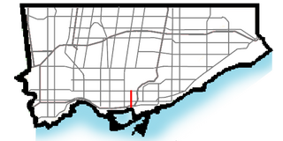
CityPlace is a neighbourhood in Downtown Toronto, Ontario, Canada, within the former Railway Lands. When completed, this area will be the largest residential development ever created in Toronto. The area is bordered by Bathurst Street to the west, Lake Shore Boulevard to the south, and Front Street to the north and Blue Jays Way and Rogers Centre to the east. Cityplace is also a five-to-ten-minute walk from King Street West and Liberty Village and a ten-to-twenty-minute walk from Toronto's financial district. The neighbourhood is also home to the Canoe Landing Park, designed by famed Canadian writer and artist Douglas Coupland.

<span class="mw-page-title-main">Toronto Community Housing</span> Public housing agency

Toronto Community Housing Corporation (TCHC) is a public housing agency in Toronto, Ontario. It is the largest social housing provider in Canada with over 58,000 units across 2,100 buildings and approximately 105,000 residents. It is the second-largest housing provider in North America, behind the New York City Housing Authority.

<span class="mw-page-title-main">Davisville Village</span> Neighbourhood in Toronto, Ontario, Canada

Davisville Village is a neighbourhood of Toronto, Ontario, Canada. It is located near the intersection of Davisville Avenue and Yonge Street. There is a subway station named Davisville at this intersection. The area directly abuts Mount Pleasant Cemetery, and has many massive apartment and condominium complexes built between the 1970s and the 2000s, as well as a number of office buildings. The area is within Midtown Toronto between St Clair and Eglinton. Davisville Village is represented at Toronto City Council by Councillor Josh Matlow.

<span class="mw-page-title-main">Clairlea</span> Neighbourhood in Toronto, Ontario, Canada

Clairlea is a safe, quiet, middle to upper-middle income neighbourhood in Toronto, Ontario, Canada that features well treed streets and detached homes with large backyards. The neighbourhood is located in east Toronto just east of Victoria Park Avenue.

<span class="mw-page-title-main">West Don Lands</span> Neighbourhood in Toronto, Ontario, Canada

The West Don Lands are the site of a neighbourhood under construction in Toronto, Ontario, Canada. The area is bordered by the Don River, King Street, Parliament Street and the rail line adjacent to the Gardiner Expressway. It is 80 hectares in size. A former industrial area, the area is being rebuilt as a mixed-use neighbourhood.

<span class="mw-page-title-main">Concord Park Place</span> Development in Toronto, Ontario, Canada

Concord Park Place is a 45-acre (18 ha) multi-tower condominium complex under construction by developer Concord Adex in Toronto, Ontario.

<span class="mw-page-title-main">Alexandra Park, Toronto</span> Neighbourhood in Toronto, Ontario, Canada

Alexandra Park is a neighbourhood located in downtown Toronto, Ontario, Canada. Alexandra Park is bounded by Dundas Street West on the north, Spadina Avenue on the east, Queen Street West on the south, and Bathurst Street on the west. Alexandra Park consists of private and public housing, with at grade retail along Queen Street West and Spadina Avenue, some institutional, and several commercial buildings scattered through the neighborhood. The neighborhood takes its name from Alexandra Park, a municipal park at the south-east corner of Dundas Street West and Bathurst Street. The park is named for Queen Alexandra, whose husband, King Edward VII, was the first future monarch to visit Toronto.

<span class="mw-page-title-main">Parliament Street (Toronto)</span> Street in Toronto, Ontario, Canada

Parliament Street is a north–south street in the eastern part of downtown Toronto, Ontario, Canada. The street runs from Bloor Street to Queens Quay and is the first major street west of the Don River.

<span class="mw-page-title-main">East Garrison, California</span> Unincorporated community in California, United States

East Garrison is a planned community in an unincorporated area in Monterey County, California. It is located on Reservation Road east of Marina and west of the Salinas River on the former Fort Ord. The community has 929 taxed parcels. The community contains many parks including dog parks, the 5-acre Lincoln Park with sports field as well as West Camp Park, McArthur Park, Arts Park which are approximately one acre each. East Garrison is part of Monterey County's Fourth District and, as of January 5, 2021, is represented by Supervisor Wendy Root Askew.

<span class="mw-page-title-main">Downtown East Village, Calgary</span> Neighbourhood in Calgary, Alberta, Canada

Downtown East Village more commonly known as simply East Village, is a mixed-use neighbourhood within the eastern portions of downtown Calgary, Alberta, Canada. It is contained within the city's Rivers District. Containing the earliest-settled land in the Calgary area - Fort Calgary - East Village was for years a mixture of high-rise residential, commercial, and industrial development. Much of the parkland currently surrounding Fort Calgary was industrial as recently as the 1960s. Construction of the city's light rail transit Blue Line, coupled with the closure of 8th Avenue at Macleod Trail in the early 1980s by construction of the massive Calgary Municipal Building, resulted in East Village being "cut off," from the rest of downtown. It became home to many rundown properties and vacant lots over the years, and a severe crime problem.

<span class="mw-page-title-main">Howard County Housing and Community Development</span>

Howard County Housing is the umbrella organization for the Howard County Department of Housing and Community Development and the Howard County Housing Commission. The Department is Howard County Government’s housing agency, and the Commission is a public housing authority and non-profit. Both have boards that meet monthly.

<span class="mw-page-title-main">Poor door</span> Separate entrance in multi-unit housing

A "poor door" is a separate entrance to a multi-unit housing development for those living in less expensive apartments.

<span class="mw-page-title-main">BDP Quadrangle (architecture firm)</span> Canadian architecture and interior design firm

BDP Quadrangle is the North American studio of UK-based global architecture, design, and urbanism firm, BDP.

References

  1. "Regent Park · Toronto Community Housing". Torontohousing.ca. Retrieved 9 November 2012.
  2. 1 2 "About the Regent Park revitalization · Toronto Community Housing". Torontohousing.ca. Archived from the original on 30 October 2012. Retrieved 9 November 2012.
  3. "Toronto Community Housing unveils visionary next phase of Regent Park revitalization · Toronto Community Housing". Torontohousing.ca. 12 September 2012. Archived from the original on 17 October 2012. Retrieved 9 November 2012.
  4. "About Regent Park relocation and return · Toronto Community Housing". Torontohousing.ca. Archived from the original on 7 November 2012. Retrieved 9 November 2012.
  5. "Toronto Community Housing Celebrates the Opening of Daniels Spectrum in Regent Park · Toronto Community Housing". Torontohousing.ca. 20 September 2012. Archived from the original on 10 January 2013. Retrieved 9 November 2012.
  6. "Daniels Spectrum". danielsspectrum.ca. Archived from the original on 5 June 2023. Retrieved 21 August 2023.
  7. "We heard from Regent Park residents about how we can improve relocation and how you think we're doing with revitalization · Toronto Community Housing". Torontohousing.ca. 15 October 2012. Archived from the original on 10 January 2013. Retrieved 9 November 2012.
  8. Anna Mehler Paperny. "Is Regent Park revitalization crumbling?". The Globe and Mail. Retrieved 9 November 2012.
  9. "Doors Open: Regent Park Arts & Cultural Centre | Artscape". Torontoartscape.org. 27 October 2012. Retrieved 9 November 2012.