
India, also known as the Republic of India, is a country in South Asia. It is the seventh largest country by area and with more than 1.3 billion people, it is the second most populous country as well as the most populous democracy in the world. Bounded by the Indian Ocean on the south, the Arabian Sea on the southwest, and the Bay of Bengal on the southeast, it shares land borders with Pakistan to the west; China, Nepal, and Bhutan to the northeast; and Bangladesh and Myanmar to the east. In the Indian Ocean, India is in the vicinity of Sri Lanka and the Maldives, while its Andaman and Nicobar Islands share a maritime border with Thailand and Indonesia.

India is the second most populated country in the world with nearly a fifth of the world's population. According to the 2017 revision of the World Population Prospects, the population stood at 1,324,171,354.

Languages spoken in India belong to several language families, the major ones being the Indo-Aryan languages spoken by 78.05% of Indians and the Dravidian languages spoken by 19.64% of Indians. Languages spoken by the remaining 2.31% of the population belong to the Austroasiatic, Sino-Tibetan, Tai-Kadai and a few other minor language families and isolates. India (780) has the world's second highest number of languages, after Papua New Guinea (839).
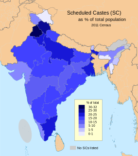
The Scheduled Castes (SCs) and Scheduled Tribes (STs) are officially designated groups of historically disadvantaged people in India. The terms are recognised in the Constitution of India and the groups are designated in one or other of the categories. For much of the period of British rule in the Indian subcontinent, they were known as the Depressed Classes. The people in scheduled castes are essentially the lowest part of Hindu society.
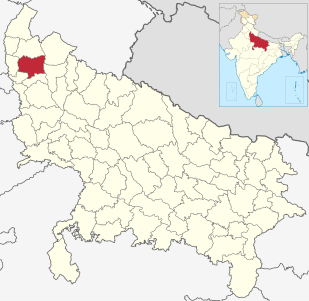
Meerut district, is one of the districts of Uttar Pradesh state of India, and Meerut is the district headquarters. Meerut district is also a part of the Meerut division. The administrative head of district of Meerut is a District Magistrate while the administrative head of Meerut Division is Divisional Commissioner, an IAS officer.

Hinduism is the largest religion in India, with 79.8% of the population identifying themselves as Hindus, that accounts for 966 million Hindus in India as of National Census of India, while 14.2% of the population follow Islam and the remaining 6% adhere to other religions. The vast majority of Hindus in India belong to Shaivite and Vaishnavite denominations. India is one of the three countries in the world where Hinduism is the majority.
The decennial Census of India has been conducted 15 times, as of 2011. While it has been undertaken every 10 years, beginning in 1872, the first complete census was taken in 1881. Post 1949, it has been conducted by the Registrar General and Census Commissioner of India under the Ministry of Home Affairs, Government of India. All the censuses since 1951 were conducted under the 1948 Census of India Act. The last census was held in 2011. The next will be held in 2021.
A census town is a type of town that satisfies certain characteristics, depending on the country in which it is located.
The 15th Indian Census was conducted in two phases, house listing and population enumeration. House listing phase began on 1 April 2010 and involved collection of information about all buildings. Information for National Population Register(NPR)was also collected in the first phase, which will be used to issue a 12-digit unique identification number to all registered Indian residents by Unique Identification Authority of India (UIDAI). The second population enumeration phase was conducted between 9 and 28 February 2011. Census has been conducted in India since 1872 and 2011 marks the first time biometric information was collected. According to the provisional reports released on 31 March 2011, the Indian population increased to 1.21 billion with a decadal growth of 17.70%. Adult literacy rate increased to 74.04% with a decadal growth of 9.21%. The motto of the census was 'Our Census, Our future'.

Avarkhod is a village in Belgaum district in the southern state of Karnataka, India.
Gulaganjikoppa is a village in Belgaum district in the southern state of Karnataka, India.
Ingalagi is a panchayat village in Belgaum district in the southern state of Karnataka, India.
Molmanatti is a village in Belgaum district of Karnataka, India.


