
The River Dearne South Yorkshire, England flows roughly east for more than 30 kilometres (19 mi), from its source just inside West Yorkshire. It flows through Denby Dale, Clayton West, Darton, Barnsley, Darfield, Wath upon Dearne, Bolton on Dearne, Adwick upon Dearne and Mexborough to its confluence with the River Don at Denaby Main. Its main tributary is the River Dove, which joins it at Darfield. The river was one of those affected by the 2007 United Kingdom floods.

The City of Chelmsford is a local government district with borough and city status in Essex, England. It is named after its main settlement, Chelmsford, which is also the county town of Essex. As well as the settlement of Chelmsford itself, the district also includes the surrounding rural area and the town of South Woodham Ferrers.

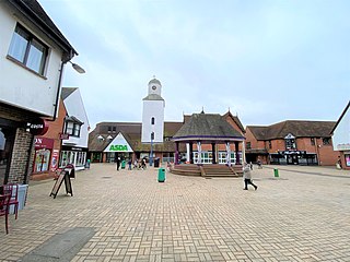
Wickford is a town and civil parish in the south of the English county of Essex, with a population of 33,486. Located approximately 30 miles (50 km) east of London, it is within the Borough of Basildon along with the original town of Basildon, Billericay, Laindon and Pitsea.

The Prittle Brook is a 7.2 mile (11.59 km) watercourse in south Essex, England. A tributary of the River Roach, the brook rises in Thundersley and passes through Hadleigh, Leigh-on-Sea, Westcliff, Prittlewell, Rochford and discharges into the Roach and then into the North Sea via the Roach and Crouch estuaries.
South Woodham Ferrers is a town and civil parish in the City of Chelmsford in Essex, England. It is approximately 35 miles (56 km) east of London and 8 miles (13 km) south-east of Chelmsford, and had a population of 16,453 at the 2011 Census, a decrease from 16,629 at the 2001 Census.

Chelmsford is a constituency in Essex represented in the House of Commons of the UK Parliament since 2017 by Vicky Ford of the Conservative Party.

The River Crouch is a small river that flows entirely through the English county of Essex.

Rochford was a County Constituency in Essex, represented in the House of Commons of the Parliament of the United Kingdom from 1983 until 1997. It elected one Member of Parliament (MP) by the first past the post system of election.

The A130 is a major road in England linking Howe Green, near Chelmsford, the county town of Essex, with Canvey Island in the south of that county. It is a primary route for some of its length, only losing that status south of the A13 junction at Sadlers Farm roundabout as it nears its terminus on Canvey Island. It was originally a much longer cross-country route.

West Hanningfield is a small village and civil parish in south Essex, England. It is located approximately 5 mi (8.0 km) south-south-east of the county town of Chelmsford. The village is in the borough of Chelmsford and in the parliamentary constituency of Maldon.
East Hanningfield is a small village in south Essex, England. It is situated to the southeast of Chelmsford and to the northwest of South Woodham Ferrers, with a population of ? It is surrounded by the villages of Butts Green, Bicknacre, Woodham Ferrers, West Hanningfield, Howe Green, and Rettendon.
The River Roach is a river that flows entirely through the English county of Essex. It is one of four main streams that originate in the Rayleigh Hills to the west, and flow east. They then flow towards the centre of the Rochford Basin, a circular feature which may have been caused by an asteroid impact in the Late Oligocene or Early Miocene periods. To the east of Rochford, the river becomes tidal, and is governed by the Crouch Harbour Authority. It joins the River Crouch between Wallasea Island and Foulness Island. To the west of Rochford, there is some doubt as to which of the four streams is officially the Roach.

Battlesbridge is a village in Essex, England. It straddles the River Crouch which is tidal and navigable up to this point. It is approximately 14 miles (23 km) south-southeast of Chelmsford and 4 miles (6.4 km) north of Rayleigh. The north bank of the river is in the civil parish of Rettendon, while the south bank is in Rawreth. It is a suburb of the town of Wickford and falls under the postal codes used in Wickford.

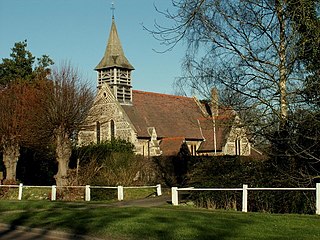
Rettendon is a small village and civil parish in the Borough of Chelmsford in Essex, England, about 8 miles (13 km) south east of the city of Chelmsford. Situated near the River Crouch, the village was once owned by the Bishop of Ely. The A130 formerly passed through the village. There are a number of listed buildings in the parish.
Chelmsford Rural District was a local government district in Essex, England from 1894 to 1974. It surrounded, but did not include, the town of Chelmsford; which formed a municipal borough.

The River Dove is a river that extends through the Low Valley in Barnsley, England. It flows from Worsbrough Reservoir to its confluence with the River Dearne.

Fenn Washland is a 4.9 hectare Local Nature Reserve in South Woodham Ferrers in Essex, England. It is owned by Essex County Council and managed by the council as a part of the nearby Marsh Farm Country Park.

Woodham Fen is an 8.1-hectare (20-acre) nature reserve in South Woodham Ferrers in Essex. It is managed by the Essex Wildlife Trust. It is part of the Crouch and Roach Estuaries Site of Special Scientific Interest.

The Roman River is a river that flows entirely through the English county of Essex. It is a tributary of the River Colne, flowing into its tidal estuary below Colchester. The lower end of the Roman River is also tidal, with tidal water flowing upstream to just above Fingringhoe.
