
Tilburg is a city and municipality in the Netherlands, in the southern province of North Brabant. With a population of 222,601, it is the second-largest city or municipality in North Brabant after Eindhoven and the seventh-largest in the Netherlands as a whole.

North Brabant, also unofficially called Brabant, is a province in the south of the Netherlands. It borders the provinces of South Holland and Gelderland to the north, Limburg to the east, Zeeland to the west, and the Flemish provinces of Antwerp and Limburg to the south. The northern border follows the Meuse westward to its mouth in the Hollands Diep strait, part of the Rhine–Meuse–Scheldt delta. North Brabant had a population of about 2,626,000 as of January 2023. Major cities in North Brabant are Eindhoven, Tilburg, Breda, its provincial capital 's-Hertogenbosch, and Helmond
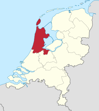
North Holland is a province of the Netherlands in the northwestern part of the country. It is located on the North Sea, north of South Holland and Utrecht, and west of Friesland and Flevoland. As of January 2023, it had a population of about 2,952,000 and a total area of 4,092 km2 (1,580 sq mi), of which 1,429 km2 (552 sq mi) is water.

Noord-Beveland is a municipality and region in the southwestern Netherlands and a former island, now part of the Walcheren-Zuid-Beveland-Noord-Beveland peninsula. Noord-Beveland is enclosed by the Oosterschelde estuary to the north, and the former straits, now combined lake, of Veerse Meer and Zandkreek to the south. As part of the Delta Works, dams have connected Noord-Beveland to Walcheren and Zuid-Beveland.

Venray or Venraij is a municipality and a city in Limburg, the Netherlands.

Bergeijk is a municipality and town in the southern Netherlands, in the province of North Brabant. It consists of an area of 101.75 km2 (39.29 sq mi) and had a population of 18,754 in 2021. It is one of 21 municipalities, including Eindhoven, that make up the Eindhoven Region Cooperative.

Oirschot is a municipality and town in the province of North Brabant (Noord-Brabant) in the southern Netherlands. It is 12 kilometres (7.5 mi) from Eindhoven and 20 kilometres (12 mi) from Tilburg. The municipality had a population of 18,842 in 2021.

Ravenstein is a city and a former municipality in the south of the Netherlands, in the province of North Brabant. The former municipality covered an area of 42.68 km². In 2003 it was incorporated into the city of Oss.

Reusel-De Mierden is a municipality in the southern Netherlands. It is located in the North Brabant province, and has an area of 78.66 km2 (30.37 sq mi). It had a population of 13,127 in 2021.

Zoetermeer is a city in the Western Netherlands, in the province of South Holland. The municipality covers an area of 37.05 km2 (14.31 sq mi) of which 2.60 km2 (1.00 sq mi) is water. A small village until the late 1960s, it had 6,392 inhabitants in 1950. By 2023 this had grown to 126.998, making it the fourth largest population centre in the province of South Holland, after Rotterdam, The Hague and Leiden. While now a city in its own right, Zoetermeer started out as a suburb of The Hague and is still a part of the Greater The Hague urban area.

Polsbroek is a village in the Dutch province of Utrecht. It is a part of the municipality of Lopik, and lies about 10 km southeast of Gouda.

Beers is a village in the former Dutch municipality of Cuijk. It is located about 4 km west of Cuijk. Since 2022 it has been part of the new municipality of Land van Cuijk.
De Hoef is the name of several locations in the Netherlands:

Reek is a village in the Dutch province of North Brabant. It is located in the former municipality of Landerd, about 3 km east of Schaijk.

Schaijk is a town in the Dutch province of North Brabant. It is located in the former municipality of Landerd, about 8 kilometres (5.0 mi) southeast of Oss.
Dutch dialects are primarily the dialects that are both cognate with the Dutch language and spoken in the same language area as the Dutch standard language. They are remarkably diverse and are found within Europe mainly in the Netherlands and northern Belgium.

Hooge Mierde is a village in the municipality of Reusel-De Mierden in the province of North Brabant, the Netherlands. It was formerly part of Hooge en Lage Mierde municipality, and since 1997 it has become part of Reusel-De Mierden.
The following is a timeline of the history of the municipality of Eindhoven, Netherlands.

Het Noordbrabants Museum is an art museum in 's-Hertogenbosch, Netherlands.

Brabants Landschap, officially Stichting het Noordbrabants Landschap, is one of the 12 provincial landscape foundations in the Netherlands.


