Revierwasserlaufanstalt Freiberg

Last updated

The Revierwasserlaufanstalt Freiberg (approximately: "Freiberg Mines Water Management System") or RWA Freiberg, was a historical water management system that delivered driving water to the Freiberg mines in the time of the German Electorate and later Kingdom of Saxony. Today the system is used to supply drinking and industrial water and is operated by the Saxony State Reservoir Office (Landestalsperrenverwaltung Sachsen).

Contents

The Revierwasseranstalt Freiberg has been selected as a candidate for the future UNESCO World Heritage Site of the Ore Mountain Mining Region (Montanregion Erzgebirge).

Ore Mountain Mining Region Industrial heritage location

The Ore Mountain Mining Region is an industrial heritage landscape, over 800 years old, in the border region between the German state of Saxony and North Bohemia in the Czech Republic. It is characterised by a plethora of historic, largely original, monuments to technology, as well as numerous individual monuments and collections related to the historic mining industry of the region. The identity and authenticity of the mining heritage landscape of the Ore Mountains on both sides of the German-Czech border has no equivalent anywhere in the world, and if the region succeeds in being recognised as a UNESCO world heritage site - for which it has been nominated - it should help to preserve it for future generations as a "developing cultural landscape".

History

Early history

The beginnings of the Revierwasserlaufanstalt coincide with the start of mining in the Freiberg region in 1168. The term "water management" in this case embraces the many facilities laid out and expanded time and again to handle water for the mining industry, such as ditches ( Kunstgräben ), water tunnels ( Röschen ) and ponds or reservoirs ( Kunstteiche ), that supplied water to the pits, stamp mills and smelteries.

<i>Kunstgraben</i>

A Kunstgraben is a type of man-made water channel that was once used by mines to drive the water wheels needed for power, mine drainage and a host of other purposes. The term is German. Similar ditches supplying water mills in England are called leats.

<i>Rösche</i>

A Rösche is a German mining term that refers inter alia to a gullet (Wasserseige), a trench for draining water in the lower part of a mine gallery. In order to keep the actual gallery entrance (Stollenmundloch) free and guard against backflooding the Röschen were, in many cases, extended to below the entrance or led even further away, underground, to the nearest stream or river.

<i>Kunstteich</i>

A Kunstteich is an historic German term for a man-made lake or pond associated with the mining industry and its technology. These ponds were created by the construction of barriers, typically dams and embankments, and were used to supply hydropower and water to the mines. Water stored in the reservoir was used for a variety of purposes. It was used to turn water wheels that in turn drove the various mechanical devices used in mining in earlier centuries, such as man engines. It was also used to produce power and drain the mines, or in the processing of ore. In principle, all Kunstteiche are small dam and reservoir installations. The oldest working dams in Germany are Kunstteiche.

1557–1853

About 1557, Martin Planer began the systematic upgrade of the water management facilities that had hitherto been laid out. This is the starting point for the facilities of the Revierwasserlaufanstalt, a system that is still in operation today. [1] The usual term for this concept at the time was Wasserversorgung ("water supply"); but from about 1846 the term Revierwasserversorgung ("mining area water supply") was used. From about 1684 the Electoral Adit and Gullet Administration of Freiberg (Kurfürstliche Stolln- und Röschen-Administration zu Freiberg), established by Prince-Elector John George III, was made responsible for water supply facilities, overseen by the Saxon Mining Office (Sächsisches Oberbergamt). [2] It was during that time that facilities such as the Kuhschachter Teich, the Zethauer Kunstgraben , the Große Großhartmannsdorfer Teich , the Müdisdorfer Kunstgraben und Rösche , the Erzengler Teich and the Hohbirker Kunstgraben were built. Because the demand for driving water grew rapidly, when this could be provided by the ever-growing system of ditches the division of water available was optimised. In order to make this comprehensible, the amount of water allocated to individual consumers had to be measured. This led, in the 18th century, to the introduction of a new unit of measurement, the "wheel of water" (Rad Wasser) whereby 100 cubic foot/min = 37.85 l/s). [1] [3] Another control mechanism was the water tax (Wassersteuer) where, in 1853, one Lachterrad (37.85l/s at 2 m drop in height for one year =1.194 Mio. m³/year) cost 20 taler. [1]

Saxon Mining Office government agency

The Saxon Mining Office is the executive authority for mining rights in the German state of Saxony. It is also responsible for all non-metallic mineral resources on the terrain of the former East Germany.

The lachter was a common unit of length used in the mining industry in Europe, usually to measure depth, tunnel driving and the size of mining fields; it was also used for contract work. In most German-speaking mining fields it was the most important unit of length.

Thaler silver coin used throughout Europe for almost four hundred years

The thaler was a silver coin used throughout Europe for almost four hundred years. Its name lives on in the many currencies called dollar and the Samoan tālā, and, until 2007, also in the Slovenian tolar.

1853–1913

Under §283 of the law covering the mining by royal assent in the Kingdom of Saxony dated 22 May 1851 the Kurfürst-Johann-Georg-Stolln, the Tiefe Fürstenstolln, the Thelersberger Stolln, the Alte tiefe Fürstenstolln, the Dörnthaler Wasserleitung, the Junger Fürst zu Sachsen Müdisdorfer Rösche, the Martelbacher Rösche the Muldenwasser-Versorgung "with all their fixtures of smelteries, mills, water tunnels, ponds, adits and galleries, whose rights and responsibilities (Rutzungen) and even their entire assets" were transferred to the "Gesammteigenthum des Freiberger Reviers" which had the title of "Revierwasserlaufsanstalt". [4]

Mining law branch of law relating to the legal requirements affecting minerals and mining

Mining law is the branch of law relating to the legal requirements affecting minerals and mining. Mining law covers several basic topics, including the ownership of the mineral resource and who can work them. Mining is also affected by various regulations regarding the health and safety of miners, as well as the environmental impact of mining.

Modern purpose

The ponds or Kunstteiche used to provide water for the mining industry in the Freiberg Mining Field, in order to drive water wheels and stamp mills and to wash the ore. They are connected to one another by around 50 km of ditches ( Kunstgräben ) and mining water tunnels ( Röschen ). The Upper RWA supplies drinking water, the Lower RWA industrial water. The RWA system also transfers today water from the Rauschenbach Reservoir to the Saidenbach Reservoir in order to supply the great residential and industrial area of Chemnitz. In addition, water is transferred from the Oberer Großhartmannsdorfer Teich via the Lichtenberg Reservoir and from there to the Klingenberg Reservoir and into the Dresden area.

Freiberg Mining Field

The Freiberg Mining Field is an ore field which, in its widest sense, is located on an ore deposit of precious and non-ferrous metals roughly 35 x 40 kilometres in area in the lower Eastern Ore Mountains in the German Free State of Saxony. The mining region is centred on Freiberg, but extends beyond that town's borough into the municipalities of Halsbrücke, Hilbersdorf, Bobritzsch, Weißenborn, Oberschöna and the boroughs of Brand-Erbisdorf and Großschirma. Mining has been carried out here since the last third of the 12th century. In a narrower sense the name refers to the area covered by the Freiburg and Halsbrück mining territories. The Brand Mining Field immediately to the south comprises just the one mining territory, the Brander Grubenfeld.

Water wheel machine for converting falling or flowing water into useful power

A water wheel is a machine for converting the energy of flowing or falling water into useful forms of power, often in a watermill. A water wheel consists of a wheel, with a number of blades or buckets arranged on the outside rim forming the driving surface.

Stamp mill type of mill machine

A stamp mill is a type of mill machine that crushes material by pounding rather than grinding, either for further processing or for extraction of metallic ores. Breaking material down is a type of unit operation.

Construction

The dams of the RWA are earth-fill dams or homogeneous dams with impervious clay cores or clay blankets on the upstream side. The dams are very wide and have steep faces. The downstream, grass-covered faces are sometimes supported by stone arches. On the upstream face the dams have a stone wall (a so-called Tarrasmauer) to guard against waves. To release the water there is a valve (Striegel) operated from the valve house (Striegelhaus) by a winch and spindle.

RWA reservoirs

Today the RWA has 10 ponds or reservoirs that are operated by the Saxony State Reservoir Agency (Landestalsperrenverwaltung Sachsen).

List of ponds in the Revierwasserlaufanstalt Freiberg

Neighbouring reservoirs

There are other reservoirs in the neighbourhood, most of which are also very old:

Related Research Articles

Upper Harz Water Regale part of a World Heritage site in Germany

The Upper Harz Water Regale is a system of dams, reservoirs, ditches and other structures, much of which was built from the 16th to 19th centuries to divert and store the water that drove the water wheels of the mines in the Upper Harz region of Germany. The term regale, here, refers to the granting of royal privileges or rights in this case to permit the use of water for mining operations in the Harz mountains of Germany.

Silberteich dam in Goslar, Lower Saxony, Germany

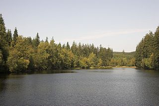
The Silberteich is a man-made reservoir, of a type called a Kunstteich, and lies on the upper reaches of the Brunnenbach stream between Braunlage and Sankt Andreasberg in the Harz Mountains of Germany. It was built as part of the historic Upper Harz Water Regale.

Kiliansteich dam in Landkreis Harz

The Kiliansteich is one of the oldest reservoirs in Germany. The reservoir is located near Straßberg (Harz) in the German state of Saxony-Anhalt and supplies drinking water. It impounds the Büschengraben stream. The lake is part of the heritage area (Flächendenkmal) of the Lower Harz Pond and Ditch System.

Lower Harz Pond and Ditch System

Within the Lower Harz region are still many traces of the historical water management facilities used by the mining industry. In addition to water-carrying ditches and ponds, there are also long-abandoned ditches and dry pond beds. The Lower Harz Pond and Ditch System, which forms the major part of these old water management facilities, lies in the central Lower Harz, almost entirely within the borough of the present-day town of Harzgerode.

Glasebacher Teich dam in Harz district, Harz Mountains, Germany

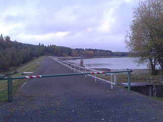
The Glasebacher Teich was an artificial reservoir or Kunstteich laid out near the village of Straßberg in the Harz Mountains of Germany for mining purposes. With a capacity of about 300,000 m³ it was the second largest pond in the Lower Harz. It impounded the Glasebach stream.

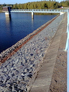
The Frankenteich is an old reservoir in the Harz Mountains of central Germany. It was constructed in 1716 under the direction of mining director (Bergwerksdirektor), Christian Zacharias Koch, for the mining industry and is the largest pond in the Lower Harz. Since 1901 it has supplied drinking water to the village of Straßberg. It impounds the Rödelbachgraben, which discharges into the Selke in Straßberg. A mining ditch runs past the foot of the dam from the Kiliansteich which, like the Frankenteich, belongs to the heritage area designated as the Lower Harz Pond and Ditch System.

The Siebengründer Graben is a mining ditch that was constructed in 1903/1904 in the Lower Harz in central Germany. Today, it is dry.

Hüttenstollen mine in Germany

The Hüttenstollen, also Straßberger Hüttenstollen, was the central drainage adit in the Straßberg mining field and was also part of the Lower Harz Pond and Ditch System in the Harz Mountains of Germany. The adit lies at a depth of 50 m and is 750 m long. The pit water was drained into the Selke. The drainage ditches were the Straßberger Flösse and the Stollgraben.

Teufelsteich dam in Harz district, Saxony-Anhalt, Germany

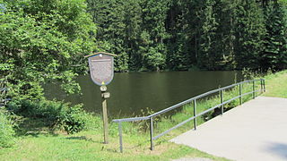
The Teufelsteich was one of the oldest reservoirs in the Harz Mountains of central Germany.

Neugrabenflöße canal

The Neugrabenflöße, was a roughly 18 km long Kunstgraben dating to the 17th century. It enabled the rafting of timber for the mining and smelting industries in the Ore Mountains of eastern Germany. It ran from the River Flöha near Fleyh (Fláje) to the Freiberger Mulde near Clausnitz in the Ore Mountains.

Graben Tour mining trail in Saxony, Germany

The Graben Tour is a mining history footpath in the north of the former district of Freiberg in the German Free State of Saxony. It follows the course of an old mining water channel, in the valley of the Bobritzsch, from Krummenhennersdorf to Reinsberg.

Bergrat Müller Pond dam in Harz, Harz county, Saxony-Anhalt

The Bergrat Müller Pond, named after a former mining director, Müller, in the Harz mountains of central Germany is a storage pond laid out from 1737 to 1738. It has an area of about 1.3 ha and lies in the forested southern part of the borough of Quedlinburg in the county of Harz in Saxony-Anhalt.

Lower Grumbach Pond dam in Between Hahnenklee and Wildemann, Goslar, Lower Saxony, GermanyClosest city: Clausthal-Zellerfeld

The Lower Grumbach Pond, usually just Grumbach Pond, is an old mining reservoir or Kunstteich between Hahnenklee and Wildemann in the Upper Harz mountains in Germany

Siebenlehn Town in Saxony, Germany

Siebenlehn is a district of the town Großschirma in Landkreis Mittelsachsen. Until 2003 it was a separate town. Upon fusion with the neighbouring rural municipality Großschirma on 1 September 2003, the town privileges were transferred to the joint municipality.

References

  1. 1 2 3 Otfried Wagenbreth (1988), Eberhard Wächtler (ed.), Der Freiberger Bergbau : Technische Denkmale und Geschichte (in German) (2. ed.), Leipzig: Deutscher Verlag für Grundstoffindustrie, pp. 62–72, ISBN   3-342-00117-8
  2. "Revierwasserlaufanstalt Freiberg" (PDF). Retrieved 2011-07-14.[ permanent dead link ]
  3. Kalender für den Sächsischen Berg- und Hütten-Mann auf das Jahr 1850., p. 81
  4. Regulativ für die Verwaltung der Revierwasserlaufs-Anstalt zu Freiberg, in: Jahrbuch für den Berg- und Hütten-Mann auf das Jahr 1854., p. 86

Sources