Serbia is a sovereign state situated at the crossroads of Central and Southeast Europe, covering the far southern edges of the Pannonian Plain (Vojvodina) and the central Balkans. It shares borders with Bosnia-Herzegovina, Bulgaria, Croatia, Hungary, North Macedonia, Montenegro, Romania and Albania through the disputed territory of Kosovo. It is landlocked, although access to the Adriatic Sea is available through Montenegro, and the Danube River provides shipping access to inland Europe and the Black Sea.

The Balkan mountain range is a mountain range in the eastern part of the Balkan Peninsula. The Balkan range runs 560 km from the Vrashka Chuka Peak on the border between Bulgaria and Serbia eastward through central Bulgaria to Cape Emine on the Black Sea. The highest peaks of the Balkan Mountains are in central Bulgaria. The highest peak is Botev at 2,376 m, which makes the mountain range the third highest in the country, after Rila and Pirin. The mountains are the source of the name of the Balkan Peninsula.

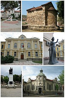
The Nišava District is one of nine administrative districts of Southern and Eastern Serbia. It expands to the south-eastern parts of Serbia. According to the 2011 census results, it has a population of 372,404 inhabitants. The administrative center of the district is the city of Niš.

Niška Banja is one of five city municipalities which constitute the city of Niš. It is also one of the spa resorts in Serbia. It is located 9 kilometres (5.6 mi) east of Niš.

Suva Planina is a mountain in southeastern Serbia. It lies between towns of Niška Banja on the northwest and Babušnica on the southeast, with a ridge branching towards Bela Palanka on north. Its earlier name was Kunovica.

Golija (Srbija) is a mountain in southwestern Serbia, between towns of Ivanjica and Novi Pazar. It is part of the Dinaric mountain range. The mountain is heavily forested with significant biodiversity. It contains the Golija-Studenica Biosphere Reserve, the first UNESCO-MAB registered biosphere reserve in Serbia. It is also a small ski resort, with several historical monuments and monasteries. The highest peak is Jankov kamen at 1,833 m.

Goljak is a mountainous region in the eastern part of Kosovo,, bordering the Lab region to the west. The cities of Pristina and Gjilan in Kosovo, and Sijarinska Banja in Serbia are located by the mountains. The highest peak Velja glava has an elevation of 1,181 m (3,875 ft) above sea level.
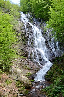
Pilj Waterfall or simply Pilj, is the third highest waterfall in Serbia, being discovered by geologists and alpinists only in 2002.
The Nerodimka is a mountain located in the south of Kosovo. It is named after the Serbian legend of the woman who cannot deliver a baby. The mountain has two high peaks, Bukova Glava 1,721 m (5,646 ft) and Kurkulica 1,549 m (5,082 ft).

Kukavica is a mountain in central Serbia, near the town of Vladičin Han. Its highest peak Vlajna has an elevation of 1442 meters above sea level.

Javor is a mountain in central Serbia, between towns of Sjenica and Ivanjica. Its highest peak Vasilin vrh has an elevation of 1,519 meters above sea level.

Milevska planina is a mountain in western Bulgaria and southeastern Serbia, near the town of Bosilegrad. Its highest peak Milevets or Krvavi kamik has an elevation of 1,738 meters above sea level. It is located at the border of Bulgaria and Serbia.
Studena planina is a mountain in central Serbia, near the city of Kraljevo. Its highest peak Kavgalija has an elevation of 1,355 meters above sea level. It stretches from west to east from the Ibar river valley towards the mountain of Goč, forming a continuous ridge with Ravna planina.
Vlaška planina is a mountain in southeastern Serbia, near the town of Dimitrovgrad. Its highest peak Panica has an elevation of 1,443 meters (4,734 ft) above sea level. With Greben, Vlaška planina forms the gorge of Jerma river.

Zvijezda is a mountain on the border of Serbia and Bosnia and Herzegovina, between towns of Bajina Bašta and Višegrad. Its highest peak Veliki Stolac lies on Bosnian territory and has an elevation of 1,673 meters above sea level, followed by Kozji rid (1591m), Pivnice (1575m), Mrka kosa (1545m), and Lisnata glavica (1510m), on Serbian side. Zvijezda lies in a large bend of the Drina river, and presents a western extension of the Tara mountain. Serbian parts of the mountain belong to the Tara National Park.
Čudinska planina or Chudinska planina, is a mountain on the border of Serbia and Bulgaria, near the town of Bosilegrad. Its highest peak Aramlija has an elevation of 1496 meters above sea level.

Stara Planina ski resort or Stara Planina ski center, is one of the largest centers of winter tourism in Serbia, operated by public company "Skijališta Srbije". Located on the slopes of Stara Planina, it is mainly a destination for skiing.