
Aberdaron is a community, electoral ward and former fishing village at the western tip of the Llŷn Peninsula in the Welsh county of Gwynedd. It lies 14+3⁄4 miles (23.7 km) west of Pwllheli and 33+1⁄2 miles (53.9 km) south west of Caernarfon, and has a population of 965. The community includes Bardsey Island, the coastal area around Porthor, and the villages of Anelog, Llanfaelrhys, Penycaerau, Rhoshirwaun, Rhydlios, Uwchmynydd and Y Rhiw. It covers an area of just under 50 square kilometres.
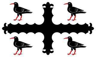
Flintshire, also known as the County of Flint, is one of Wales' thirteen historic counties, and a former administrative county. It mostly lies on the north-east coast of Wales.

The Kingdom of Powys was a Welsh successor state, petty kingdom and principality that emerged during the Middle Ages following the end of Roman rule in Britain. It very roughly covered the northern two-thirds of the modern county of Powys and part of today's English West Midlands. More precisely, and based on the Romano-British tribal lands of the Ordovices in the west and the Cornovii in the east, its boundaries originally extended from the Cambrian Mountains in the west to include the modern West Midlands region of England in the east. The fertile river valleys of the Severn and Tern are found here, and this region is referred to in later Welsh literature as "the Paradise of Powys".
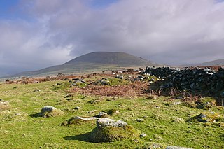
Ardudwy is an area of Gwynedd in north-west Wales, lying between Tremadog Bay and the Rhinogydd. Administratively, under the old Kingdom of Gwynedd, it was first a division of the sub kingdom (cantref) of Dunoding and later a commote in its own right. The fertile swathe of land stretching from Barmouth to Harlech was historically used as pasture. The name exists in the modern community and village of Dyffryn Ardudwy.
Rhodri ab Owain Gwynedd was prince of part of Gwynedd, one of the kingdoms of medieval Wales. He ruled from 1175 to 1195.

Powys Wenwynwyn or Powys Cyfeiliog was a Welsh kingdom which existed during the high Middle Ages. The realm was the southern portion of the former princely state of Powys which split following the death of Madog ap Maredudd of Powys in 1160: the northern portion (Maelor) went to Gruffydd Maelor and eventually became known as Powys Fadog; while the southern portion (Cyfeiliog) going to Owain Cyfeiliog and becoming known, eventually, as Powys Wenwynwyn after Prince Gwenwynwyn ab Owain, its second ruler.

Maelienydd, sometimes spelt Maeliennydd, was a cantref and lordship in east central Wales covering the area from the River Teme to Radnor Forest and the area around Llandrindod Wells. The area, which is mainly upland, is now in Powys. During the Middle Ages it was part of the region known as Rhwng Gwy a Hafren and its administrative centre was at Cefnllys Castle.

Sarn Helen refers to several stretches of Roman road in Wales. The 160-mile (260 km) route, which follows a meandering course through central Wales, connects Aberconwy in the north with Carmarthen in the west. Despite its length, academic debate continues as to the precise course of the Roman road. Many sections are now used by the modern road network while other parts are still traceable. However, there are sizeable stretches that have been lost and are unidentifiable.
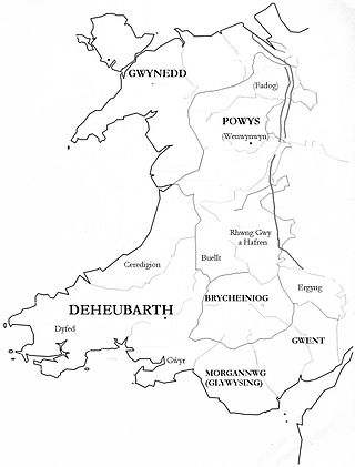
Gwent was a medieval Welsh kingdom, lying between the Rivers Wye and Usk. It existed from the end of Roman rule in Britain in about the 5th century until the Norman invasion of Wales in the 11th century. Along with its neighbour Glywyssing, it seems to have had a great deal of cultural continuity with the earlier Silures, keeping their own courts and diocese separate from the rest of Wales until their conquest by Gruffydd ap Llywelyn. Although it recovered its independence after his death in 1063, Gwent was the first of the Welsh kingdoms to be overrun following the Norman conquest.

Penmachno is a village in the isolated upland Machno valley, 4 miles (6 km) south of Betws-y-Coed in the county of Conwy, North Wales. The B4406 road runs through part of the village. The village is at the confluence of the Glasgwm and Machno rivers. It has a five-arched, stone bridge dating from 1785. The village has been referred to as Pennant Machno, Llandudclyd and Llan dutchyd in historical sources.

Glywysing was, from the sub-Roman period to the Early Middle Ages, a petty kingdom in south-east Wales. Its people were descended from the Iron Age tribe of the Silures, and frequently in union with Gwent, merging to form Morgannwg.

Anwyl of Tywyn are a Welsh family who claim a patrilinear descent from Owain Gwynedd, King of Gwynedd from 1137 to 1170 and a scion of the royal House of Aberffraw. The family motto is: Eryr eryrod Eryri, which translates as "The Eagle of the Eagles of Snowdonia. The family lives in Gwynedd and speak Welsh.

Parc is the name of an ancient mansion found near the village of Croesor in the community of Llanfrothen near Penrhyndeudraeth, in Gwynedd, Wales. The former mansion has been in ruins since the end of the 17th century when the resident Anwyl Family moved to Llugwy. Thomas Nicholas described the site in his Annals and Antiquities of the Counties and County Families of Wales [see box].
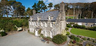
Llanfendigaid Estate, located on the Cardigan Bay coast of southern Gwynedd, near Tywyn in north Wales is a mid-Georgian house that has belonged to the same family for over 600 years. Llanfendigaid is listed Grade II* by Cadw which is only given to houses of exceptional historic interest. The estate once encompassed over 16,000 acres (65 km2), is now reduced to 16 acres (0.065 km2) within the Snowdonia National Park.

Llugwy is the name of an old property near Pennal, a village on the A493 road in southern Gwynedd, Wales, on the north bank of the Afon Dyfi/River Dovey, near Machynlleth. It lies in the former county of Merionethshire/Sir Feirionnydd, and is within the Snowdonia National Park.

Plas yn Rhiw is an early 17th-century manor house in Y Rhiw, Gwynedd in northwestern Wales. The estate consists of a small house of Tudor/Georgian style, a garden of just under one acre in size, and many wooded acres. Located at the base of Mynydd Rhiw, the estate overlooks the beach of Porth Neigwl, Cardigan Bay, and the Llŷn Peninsula.
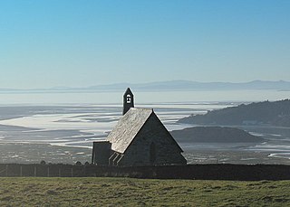
Llandecwyn is a hamlet near Penrhyndeudraeth in Gwynedd, Wales.
The Battle of the Conwy took place in 881 between King Anarawd and his brothers of the northern Welsh Kingdom of Gwynedd and a Mercian army almost certainly led by Æthelred, Lord of the Mercians. The Welsh were victorious, and the battle ended the traditional hegemony of Mercia over north Wales and contributed to Æthelred's decision to accept the lordship of King Alfred the Great of Wessex. This united the Anglo-Saxons who were not living under Viking rule under Alfred, and was a step towards the creation of the Kingdom of England. Anarawd allied himself with the Vikings shortly after the battle, but he then abandoned this alliance to follow Æthelred in accepting Alfred's lordship.

Llanegryn is a village and a community in Gwynedd, north-west Wales. It was formerly part of the historic county of Merionethshire. It is located within Snowdonia National Park south of the Snowdonia (Eryri) mountain range. Travelling by road, it is around 4 miles (6 km) north-east of Tywyn and 17 miles (27 km) south-west of Dolgellau. The nearest railway stations are at Tonfanau and Llwyngwril, both less than 3 miles (5 km) away.

Bro Machno is a community in Conwy County Borough, in Wales, formed from the former civil parish of Penmachno. It covers the Penmachno Valley, through which runs the Afon Machno, and includes the villages of Penmachno and Cwm Penmachno. To the south west borders Gwynedd, and is located 4.8 miles (7.7 km) south of Betws-y-Coed, 21.8 miles (35.1 km) north west of Corwen, and 19.4 miles (31.2 km) south of Conwy. The whole of the community is within the Snowdonia national park, while much of it forms part of Gwydir Forest. According to the 2011 census, the population of the Bro Machno Parish was 617, of whom 342 (55%) were able to speak Welsh and 214 (34%) had no skills in Welsh.


