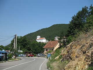
Ribare (Žagubica)

Last updated
Ribare
Рибаре
Village
Serbia adm location map.svg
Red pog.svg
Ribare
Coordinates: 44°14′N21°41′E / 44.233°N 21.683°E / 44.233; 21.683
CountryFlag of Serbia.svg  Serbia
District Braničevo District
Municipality Žagubica
Population (2002)
  Total 485
Time zone CET (UTC+1)
  Summer (DST) CEST (UTC+2)

Ribare is a village in the municipality of Žagubica, Serbia. According to the 2002 census, the village has a population of 485 people. [1]

Village Small clustered human settlement smaller than a town

A village is a clustered human settlement or community, larger than a hamlet but smaller than a town, with a population ranging from a few hundred to a few thousand. Though villages are often located in rural areas, the term urban village is also applied to certain urban neighborhoods. Villages are normally permanent, with fixed dwellings; however, transient villages can occur. Further, the dwellings of a village are fairly close to one another, not scattered broadly over the landscape, as a dispersed settlement.

Žagubica Village and municipality in Southern and Eastern Serbia, Serbia

Žagubica is a village and municipality located in the Braničevo District of the eastern Serbia. It is situated in the geographical region of Homolje. In 2011, the population of the village is 2,584, while population of the municipality is 12,737.

Serbia Republic in Southeastern Europe

Serbia, officially the Republic of Serbia, is a country situated at the crossroads of Central and Southeast Europe in the southern Pannonian Plain and the central Balkans. It borders Hungary to the north, Romania to the northeast, Bulgaria to the southeast, North Macedonia to the south, Croatia and Bosnia and Herzegovina to the west, and Montenegro to the southwest. The country claims a border with Albania through the disputed territory of Kosovo. Serbia's population numbers approximately seven million, most of whom are Orthodox Christians. Its capital, Belgrade, ranks among the oldest and largest citiеs in southeastern Europe.

Related Research Articles

Santarém District District of Portugal

The District of Santarém is a district of Portugal, located in Portugal's Centro Region. The district capital is the city of Santarém.

Sejkov municipality of Slovakia

Sejkov is a village and municipality in the Sobrance District in the Košice Region of east Slovakia.

Chotča municipality of Slovakia

Chotča is a village and municipality in Stropkov District in the Prešov Region of north-eastern Slovakia.

Butimanu Commune in Dâmbovița County, Romania

Butimanu is a commune in Romania. It is located in Dâmbovița County. It is composed of four villages: Bărbuceanu, Butimanu, Lucianca and Ungureni. It is situated in the historical region of Muntenia.

Husnicioara Commune in Mehedinți County, Romania

Husnicioara is a commune located in Mehedinți County, Romania. It is composed of eleven villages: Alunișul, Bădițești, Borogea, Celnata, Dumbrăvița, Husnicioara, Marmanu, Oprănești, Peri, Priboiești and Selișteni.

Mihail Kogălniceanu is a commune located in Ialomița County, Romania. It is composed of two villages, Hagieni and Mihail Kogălniceanu.

Fierbinți-Târg Town in Ialomița County, Romania

Fierbinți-Târg is a town in Ialomița County, Romania. The town administers three villages: Fierbinții de Jos, Fierbinții de Sus and Grecii de Jos.

Crețeni Commune in Vâlcea County, Romania

Crețeni is a commune located in Vâlcea County, Romania. It is composed of four villages: Crețeni, Izvoru, Mrenești and Streminoasa.

Cepari Commune in Argeș County, Romania

Cepari is a commune in Argeș County, in southern central Romania. It is composed of eight villages: Cărpeniș, Ceparii Pământeni, Ceparii Ungureni, Morăști, Șendrulești, Urluiești, Valea Măgurei and Zamfirești.

Mogoșani Commune in Dâmbovița County, Romania

Mogoșani is a commune in Dâmbovița County, southern Romania with a population of 4,510 people. It is composed of five villages: Chirca, Cojocaru, Merii, Mogoșani and Zăvoiu.

Niculești Commune in Dâmbovița County, Romania

Niculești is a commune in Dâmbovița County, southern Romania with a population of 4,463 people. It is composed of three villages: Ciocănari, Movila and Niculești.

Orodel Commune in Dolj County, Romania

Orodel is a commune in Dolj County, Romania with a population of 3,242 people. It is composed of five villages: Bechet, Călugărei, Cornu, Orodel, and Teiu.

Fălcoiu Commune in Olt County, Romania

Fălcoiu is a commune in Olt County, Romania. It is composed of three villages: Cioroiașu, Cioroiu and Fălcoiu.

Bâlvănești Commune in Mehedinți County, Romania

Bâlvănești is a commune located in Mehedinți County, Romania. It is composed of five villages: Bâlvănești, Bâlvăneștii de Jos, Călineștii de Jos, Călineștii de Sus and Pârlagele. It is situated in the historical region of Oltenia.

Uştalqışlaq is a village and municipality in the Ismailli Rayon of Azerbaijan. It has a population of 233.

Qazbölük is a village in the municipality of Meşəşambul in the Balakan Rayon of Azerbaijan.

Krnjeuša Village in Bosanski Petrovac, Bosnia and Herzegovina

Krnjeuša is a village in the municipality of Bosanski Petrovac, Bosnia and Herzegovina.

Chernushka is the name of several inhabited localities in Russia.

Rudnica (Raška) Village in Raška District, Serbia

Rudnica is a village in the municipality of Raška, Serbia.

Dubravica, Požarevac Village in Braničevo District, Serbia

Dubravica is a village in the municipality of Požarevac, Serbia.

References

  1. Popis stanovništva, domaćinstava i Stanova 2002. Knjiga 1: Nacionalna ili etnička pripadnost po naseljima. Republika Srbija, Republički zavod za statistiku Beograd 2003. ISBN   86-84433-00-9

Coordinates: 44°14′N21°41′E / 44.233°N 21.683°E / 44.233; 21.683

Geographic coordinate system Coordinate system

A geographic coordinate system is a coordinate system that enables every location on Earth to be specified by a set of numbers, letters or symbols. The coordinates are often chosen such that one of the numbers represents a vertical position and two or three of the numbers represent a horizontal position; alternatively, a geographic position may be expressed in a combined three-dimensional Cartesian vector. A common choice of coordinates is latitude, longitude and elevation. To specify a location on a plane requires a map projection.