Related Research Articles

Waseca County is a county in the U.S. state of Minnesota. As of the 2020 census, the population was 18,968. Its county seat is Waseca.
Traverse County is a county in the U.S. state of Minnesota. As of the 2020 census, the population was 3,360, making it the least-populous county in Minnesota. Its county seat is Wheaton. The county was founded in 1862 and organized in 1881.

Steele County is a county in the U.S. state of Minnesota. As of the 2020 census, the population was 37,406. Its county seat is Owatonna.

Rice County is a county located in the south central portion of the U.S. state of Minnesota. As of the 2020 census, the population was 67,097. Its county seat is Faribault.

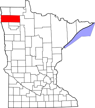
Polk County is a county in the northwestern part of the U.S. state of Minnesota. The population was 31,192 at the 2020 census. Its county seat is Crookston, and the largest community is East Grand Forks.

Norman County is a county in the northwestern part of the U.S. state of Minnesota. As of the 2020 census, the population was 6,441. Its county seat is Ada. The county is in Minnesota's Red River Valley region.
Marshall County is a county in the northwestern part of the U.S. state of Minnesota. As of the 2020 census, the population was 9,040. Its county seat is Warren.

Mahnomen County is a county in the U.S. state of Minnesota. As of the 2020 census, the population was 5,411. Its county seat is Mahnomen.
Kanabec County is a county in the East Central part of U.S. state of Minnesota. As of the 2020 census, the population was 16,032. Its county seat is Mora.

Freeborn County is a county in the state of Minnesota. As of the 2020 census, the population was 30,895. Its county seat is Albert Lea. Freeborn County comprises the Albert Lea Micropolitan Statistical Area.

Clearwater County is a county in the northwestern part of the U.S. state of Minnesota. As of the 2020 census, the population was 8,524. Its county seat is Bagley.

Aitkin County is a county in the U.S. state of Minnesota. As of the 2020 census, the population was 15,697. Its county seat is Aitkin. Part of the Mille Lacs Indian Reservation is in the county. The county was created in 1857 and organized in 1871.

Bois Forte Indian Reservation is an Indian reservation formed for the Bois Forte Band of Chippewa.

The Blue Earth River is a tributary of the Minnesota River, 108 miles (174 km) long, in southern Minnesota in the United States. Two of its headwaters tributaries, the Middle Branch Blue Earth River and the West Branch Blue Earth River, also flow for short distances in northern Iowa. By volume, it is the Minnesota River's largest tributary, accounting for 46% of the Minnesota's flow at the rivers' confluence in Mankato. Via the Minnesota River, the Blue Earth River is part of the watershed of the Mississippi River, draining an area of 3,486 square miles (9,030 km2) in an agricultural region. Ninety percent of the river's watershed is in Minnesota. It is a Minnesota Department of Natural Resources designated Water Trail.

The Watonwan River is a tributary of the Blue Earth River, 113 miles (182 km) long, in southern Minnesota in the United States. Via the Blue Earth and Minnesota rivers, it is part of the watershed of the Mississippi River, draining an area of 878 square miles (2,270 km2) in an agricultural region. The Watonwan drains about a quarter of the Blue Earth River's watershed.
The Yellow Bank River is a 12.0-mile-long (19.3 km) tributary of the Minnesota River in western Minnesota in the United States. It is formed by the confluence of two longer streams, the North Fork Yellow Bank River and the South Fork Yellow Bank River, which also flow in northeastern South Dakota. Via the Minnesota River, the Yellow Bank River is part of the watershed of the Mississippi River, draining an area of approximately 460 square miles (1,190 km²) in an agricultural region.

The Whitewater River is a 16.6-mile-long (26.7 km) tributary of the Upper Mississippi River which flows through the Driftless Area of Minnesota, reaching its mouth in Wabasha County at the community of Weaver opposite Buffalo, Wisconsin. The nearest towns are Altura, Saint Charles, and Elba. The region hosts endangered native dry oak savannas, semiforested areas that seem to have been dependent on fire for their well-being.
The Wild Rice River is a river of Minnesota. It is a tributary of the Little Fork River.
References
- ↑ U.S. Geological Survey Geographic Names Information System: Rice River (Big Fork River tributary)
- ↑ "Wild Rice River | Minnesota Pollution Control Agency". www.pca.state.mn.us. Retrieved 2024-05-30.
- ↑ "Wild Rice River | Minnesota Pollution Control Agency". www.pca.state.mn.us. Retrieved 2024-05-30.