Related Research Articles

Mercury is the first planet from the Sun and the smallest in the Solar System. In English, it is named after the ancient Roman god Mercurius (Mercury), god of commerce and communication, and the messenger of the gods. Mercury is classified as a terrestrial planet, with roughly the same surface gravity as Mars. The surface of Mercury is heavily cratered, as a result of countless impact events that have accumulated over billions of years. Its largest crater, Caloris Planitia, has a diameter of 1,550 km (960 mi) and one-third the diameter of the planet. Similarly to the Earth's Moon, Mercury's surface displays an expansive rupes system generated from thrust faults and bright ray systems formed by impact event remnants.
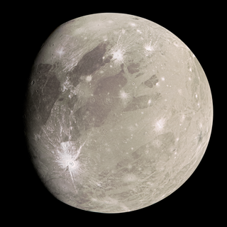
Ganymede, or Jupiter III, is the largest and most massive natural satellite of Jupiter and in the Solar System. It is the largest Solar System object without a substantial atmosphere, despite being the only moon in the Solar System with a substantial magnetic field. Like Titan, Saturn's largest moon, it is larger than the planet Mercury, but has somewhat less surface gravity than Mercury, Io, or the Moon due to its lower density compared to the three.
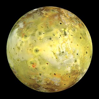
Io, or Jupiter I, is the innermost and second-smallest of the four Galilean moons of the planet Jupiter. Slightly larger than Earth's moon, Io is the fourth-largest moon in the Solar System, has the highest density of any moon, the strongest surface gravity of any moon, and the lowest amount of water by atomic ratio of any known astronomical object in the Solar System. It was discovered in 1610 by Galileo Galilei and was named after the mythological character Io, a priestess of Hera who became one of Zeus's lovers.

A cryovolcano is a type of volcano that erupts gases and volatile material such as liquid water, ammonia, and hydrocarbons. The erupted material is collectively referred to as cryolava; it originates from a reservoir of subsurface cryomagma. Cryovolcanic eruptions can take many forms, such as fissure and curtain eruptions, effusive cryolava flows, and large-scale resurfacing, and can vary greatly in output volumes. Immediately after an eruption, cryolava quickly freezes, constructing geological features and altering the surface.

Satellite geodesy is geodesy by means of artificial satellites—the measurement of the form and dimensions of Earth, the location of objects on its surface and the figure of the Earth's gravity field by means of artificial satellite techniques. It belongs to the broader field of space geodesy. Traditional astronomical geodesy is not commonly considered a part of satellite geodesy, although there is considerable overlap between the techniques.
Radioglaciology is the study of glaciers, ice sheets, ice caps and icy moons using ice penetrating radar. It employs a geophysical method similar to ground-penetrating radar and typically operates at frequencies in the MF, HF, VHF and UHF portions of the radio spectrum. This technique is also commonly referred to as "Ice Penetrating Radar (IPR)" or "Radio Echo Sounding (RES)".

Interferometric synthetic aperture radar, abbreviated InSAR, is a radar technique used in geodesy and remote sensing. This geodetic method uses two or more synthetic aperture radar (SAR) images to generate maps of surface deformation or digital elevation, using differences in the phase of the waves returning to the satellite or aircraft. The technique can potentially measure millimetre-scale changes in deformation over spans of days to years. It has applications for geophysical monitoring of natural hazards, for example earthquakes, volcanoes and landslides, and in structural engineering, in particular monitoring of subsidence and structural stability.

The surface of Venus is dominated by volcanic features and has more volcanoes than any other planet in the Solar System. It has a surface that is 90% basalt, and about 65% of the planet consists of a mosaic of volcanic lava plains, indicating that volcanism played a major role in shaping its surface. There are more than 1,000 volcanic structures and possible periodic resurfacing of Venus by floods of lava. The planet may have had a major global resurfacing event about 500 million years ago, from what scientists can tell from the density of impact craters on the surface. Venus has an atmosphere rich in carbon dioxide, with a pressure that is 90 times that of Earth's atmosphere.
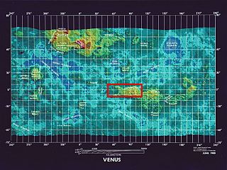
Ovda Regio is a Venusian crustal plateau located near the equator in the western highland region of Aphrodite Terra that stretches from 10°N to 15°S and 50°E to 110°E. Known as the largest crustal plateau in Venus, the regio covers an area of approximately 15,000,000 square kilometres (5,800,000 sq mi) and is bounded by regional plains to the north, Salus Tessera to the west, Thetis Regio to the east, and Kuanja as well as Ix Chel chasmata to the south. The crustal plateau serves as a place to hold the localized tessera terrains in the planet, which makes up roughly 8% of Venus' surface area. The kinematic evolution of crustal plateaus on Venus has been a debated topic in the planetary science community. Understanding its complex evolution is expected to contribute to a better knowledge of the geodynamic history of Venus. It is named after a Marijian forest spirit that can appear as both male and female.
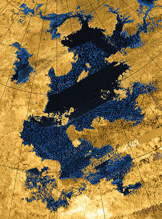
Kraken Mare is the largest known body of liquid on the surface of Saturn's moon Titan. It was discovered by the space probe Cassini in 2006, and was named in 2008 after the Kraken, a legendary sea monster. It covers an area slightly bigger than the Caspian Sea on Earth, making it the largest known lake in the Solar System.

Almost all water on Mars today exists as ice, though it also exists in small quantities as vapor in the atmosphere. What was thought to be low-volume liquid brines in shallow Martian soil, also called recurrent slope lineae, may be grains of flowing sand and dust slipping downhill to make dark streaks. While most water ice is buried, it is exposed at the surface across several locations on Mars. In the mid-latitudes, it is exposed by impact craters, steep scarps and gullies. Additionally, water ice is also visible at the surface at the north polar ice cap. Abundant water ice is also present beneath the permanent carbon dioxide ice cap at the Martian south pole. More than 5 million km3 of ice have been detected at or near the surface of Mars, enough to cover the whole planet to a depth of 35 meters (115 ft). Even more ice might be locked away in the deep subsurface. Some liquid water may occur transiently on the Martian surface today, but limited to traces of dissolved moisture from the atmosphere and thin films, which are challenging environments for known life. No evidence of present-day liquid water has been discovered on the planet's surface because under typical Martian conditions, warming water ice on the Martian surface would sublime at rates of up to 4 meters per year. Before about 3.8 billion years ago, Mars may have had a denser atmosphere and higher surface temperatures, potentially allowing greater amounts of liquid water on the surface, possibly including a large ocean that may have covered one-third of the planet. Water has also apparently flowed across the surface for short periods at various intervals more recently in Mars' history. Aeolis Palus in Gale Crater, explored by the Curiosity rover, is the geological remains of an ancient freshwater lake that could have been a hospitable environment for microbial life. The present-day inventory of water on Mars can be estimated from spacecraft images, remote sensing techniques, and surface investigations from landers and rovers. Geologic evidence of past water includes enormous outflow channels carved by floods, ancient river valley networks, deltas, and lakebeds; and the detection of rocks and minerals on the surface that could only have formed in liquid water. Numerous geomorphic features suggest the presence of ground ice (permafrost) and the movement of ice in glaciers, both in the recent past and present. Gullies and slope lineae along cliffs and crater walls suggest that flowing water continues to shape the surface of Mars, although to a far lesser degree than in the ancient past.

Venus snow is a brightening of the radar reflection from the surface of Venus at high elevations. The "snow" appears to be a mineral condensate of lead(II) sulfide and bismuth sulfide precipitated from the atmosphere at altitudes above 2,600 m (8,500 ft).

Glaciers, loosely defined as patches of currently or recently flowing ice, are thought to be present across large but restricted areas of the modern Martian surface, and are inferred to have been more widely distributed at times in the past. Lobate convex features on the surface known as viscous flow features and lobate debris aprons, which show the characteristics of non-Newtonian flow, are now almost unanimously regarded as true glaciers.
Donald B. Campbell is an Australian-born astronomer and Professor of Astronomy at Cornell University. Prior to joining the Cornell faculty he was Director of the Arecibo Observatory in Puerto Rico for seven years. Campbell's research work is in the general area of planetary studies with a concentration on the radio-wavelength-scattering properties of planets, planetary satellites, and small bodies. His work includes studies of Venus, the Moon, the Galilean satellites of Jupiter, Titan, as well as comets and asteroids. Campbell observed near-Earth asteroid 433 Eros, which was the first asteroid detected by the Arecibo Observatory radar system.
Planetary oceanography, also called astro-oceanography or exo-oceanography, is the study of oceans on planets and moons other than Earth. Unlike other planetary sciences like astrobiology, astrochemistry, and planetary geology, it only began after the discovery of underground oceans in Saturn's moon Titan and Jupiter's moon Europa. This field remains speculative until further missions reach the oceans beneath the rock or ice layer of the moons. There are many theories about oceans or even ocean worlds of celestial bodies in the Solar System, from oceans made of diamond in Neptune to a gigantic ocean of liquid hydrogen that may exist underneath Jupiter's surface.

Chemical cycling describes systems of repeated circulation of chemicals between other compounds, states and materials, and back to their original state, that occurs in space, and on many objects in space including the Earth. Active chemical cycling is known to occur in stars, many planets and natural satellites.
Atmospheric correction for Interferometric Synthetic ApertureRadar (InSAR) technique is a set of different methods to remove artefact displacement from an interferogram caused by the effect of weather variables such as humidity, temperature, and pressure. An interferogram is generated by processing two synthetic-aperture radar images before and after a geophysical event like an earthquake. Corrections for atmospheric variations are an important stage of InSAR data processing in many study areas to measure surface displacement because relative humidity differences of 20% can cause inaccuracies of 10–14 cm InSAR due to varying delays in the radar signal. Overall, atmospheric correction methods can be divided into two categories: a) Using Atmospheric Phase Screen (APS) statistical properties and b) Using auxiliary (external) data such as GPS measurements, multi-spectral observations, local meteorological models, and global atmospheric models.
References
- ↑ Goldstein, Richard M (1962). Radar Exploration of Venus (Ph.D.). Caltech.
- ↑ Goldstein, RM, R. M.; Carpenter, RL (1963). "Rotation of Venus - Period Estimated from RADAR Measurements". Science. 139 (355): 910–1. Bibcode:1963Sci...139..910G. doi:10.1126/science.139.3558.910. PMID 17743054. S2CID 21133097.
- ↑ Carpenter, Roland; Goldstein, R. M. (1963). "Radar Observations of Mercury". Science. 142 (3590): 381–2. Bibcode:1963Sci...142..381C. doi:10.1126/science.142.3590.381. PMID 17799479.
- ↑ Goldstein, R. M.; Gillmore, Willard F. (1963). "Radar Observations of Mars". Science. 141 (3586): 1171–1172. Bibcode:1963Sci...141.1171G. doi:10.1126/science.141.3586.1171-a. PMID 17751790. S2CID 40372264.
- ↑ Goldstein, R. M. (1968). "Radar Observations of Icarus". Science. 162 (3856): 903–904. Bibcode:1968Sci...162..903G. doi:10.1126/science.162.3856.903. PMID 17769079. S2CID 129644095.
- ↑ Goldstein, RM; Jurgens, RF; Sekanina, Z (1984). "A RADAR Study of Comet IRAS-Araki-Alcock 1983D". Astronomical Journal. 89 (11): 1745. Bibcode:1984AJ.....89.1745G. doi:10.1086/113683.
- ↑ Goldstein, R. M.; Rumsey, Howard C. (1972). "A Radar Image of Venus". Icarus. 17 (3): 699–703. Bibcode:1972Icar...17..699G. doi:10.1016/0019-1035(72)90034-6.
- ↑ Goldstein, R. M.; Morris, G. A. (1975). "Ganymede: Observations by Radar". Science. 188 (4194): 1211–1212. Bibcode:1975Sci...188.1211G. doi:10.1126/science.188.4194.1211. PMID 17818164. S2CID 7148034.
- ↑ Ostro, S. J.; Campbel, D. B.; Simpson, R. A.; Hudson, R. S.; Chandler, J. F.; Rosema, K. D.; Shapiro, I. I.; Standish, E. M.; et al. (1992). "Europa, Ganymede, and Callisto - New RADAR Results from Arecibo and Goldstone". Journal of Geophysical Research: Planets. 97 (E11): 18227. Bibcode:1992JGR....9718227O. doi:10.1029/92JE01992.
- ↑ Goldstein, R. M.; Morris, G. A. (1973). "Radar Observations of the rings of Saturn". Icarus. 20 (3): 260. Bibcode:1973Icar...20..260G. doi:10.1016/0019-1035(73)90002-X.
- ↑ Zebker, H. A.; Goldstein, R. M. (1986). "Topographic Mapping From Interferometric Synthetic Aperture Radar Observations". Journal of Geophysical Research. 91 (B5): 4993–4999. Bibcode:1986JGR....91.4993Z. doi:10.1029/JB091iB05p04993.
- ↑ Goldstein, R. M.; Zebker, H. A.; Werner, C. L. (1988). "Satellite radar interferometry - Two-dimensional phase unwrapping". Radio Science. 23 (4): 713–720. Bibcode:1988RaSc...23..713G. doi:10.1029/RS023i004p00713.
- ↑ Rosen, P.A.; Hensley, S.; Joughin, I.R.; Li, F.K.; Madsen, S.N.; Rodriguez, E.; Goldstein, R.M. (2000). "Synthetic aperture radar interferometry - Invited paper". Proceedings of the IEEE. 88 (3): 333. CiteSeerX 10.1.1.24.9675 . doi:10.1109/5.838084. S2CID 15478373.
- ↑ Zebker, Howard A.; Goldstein, Richard M. (1986). "Topographic Mapping from Interferometric Synthetic Aperture RADAR Observations". Journal of Geophysical Research: Solid Earth. 91 (B5): 4993. Bibcode:1986JGR....91.4993Z. doi:10.1029/JB091iB05p04993.
- ↑ Li, F.K.; Goldstein, R.M. (1990). "Studies of Multibaseline Spaceborne Interferometric Synthetic Aperture RADARS". IEEE Transactions on Geoscience and Remote Sensing. 28 (1): 88. Bibcode:1990ITGRS..28...88L. doi:10.1109/36.45749.
- ↑ Fielding, Eric J.; Blom, Ronald G.; Goldstein, Richard M. (1998). "Rapid subsidence over oil fields measured by SAR interferometry". Geophysical Research Letters. 25 (17): 3215. Bibcode:1998GeoRL..25.3215F. doi: 10.1029/98GL52260 . S2CID 127908532.
- ↑ Goldstein, R. M.; Engelhardt, H.; Kamb, B.; Froclich, R. M. (1993). "Satellite RADAR Interferometry for Monitoring Ice-sheet Motion - Application to an Antarctic Ice Stream". Science. 262 (5139): 1525–30. Bibcode:1993Sci...262.1525G. doi:10.1126/science.262.5139.1525. PMID 17829380. S2CID 42622639.
- ↑ Goldstein, R. M.; Zebker, H.A. (1987). "Interferometric RADAR Measurement of Ocean Surface Currents". Nature. 328 (6132): 707. doi:10.1038/328707a0. S2CID 4341399.
- ↑ Zebker, Howard A.; Rosen, Paul A.; Goldstein, Richard M.; Gabriel, Andrew; Werner, Charles L. (1994). "On the Derivation of Coseismic Displacement-fields using Differential RADAR Interferometry - The Landers Earthquake". Journal of Geophysical Research: Solid Earth. 99 (B10): 19617. Bibcode:1994JGR....9919617Z. CiteSeerX 10.1.1.37.4717 . doi:10.1029/94JB01179.
- ↑ Goldstein, R. M.; Werner, C. L. (1998). "Radar interferogram filtering for geophysical applications". Geophysical Research Letters. 25 (21): 4035–4038. Bibcode:1998GeoRL..25.4035G. doi: 10.1029/1998GL900033 .
- ↑ Committee on Space Debris, National Research Council (1995). Orbital debris: a technical assessment. National Academies Press. ISBN 978-0309051255.
- ↑ Goldstein, R. M.; Goldstein, S. J.; Kessler, D. J. (1998). "Radar observations of space debris". Planetary and Space Science. 46 (8): 1007–1013. Bibcode:1998P&SS...46.1007G. doi:10.1016/S0032-0633(98)00026-9.
- ↑ "JPL Annual Invention Challenge". Jet Propulsion Laboratory . Archived from the original on 9 March 2012. Retrieved 11 March 2012.
- ↑ Schmadel, Lutz D.; International Astronomical Union (2003). Dictionary of Minor Planet Names, Volume 1. Springer Verlag. p. 461. ISBN 9783540002383.