
Indiana Dunes National Park is a United States national park located in northwestern Indiana managed by the National Park Service. It was authorized by Congress in 1966 as the Indiana Dunes National Lakeshore and was redesignated as the nation's 61st national park on February 15, 2019. The park runs for about 20 miles (32 km) along the southern shore of Lake Michigan and covers 15,349 acres (6,212 ha). Along the lakefront, the eastern area is roughly the lake shore south to U.S. 12 or U.S. 20 between Michigan City, Indiana, on the east and the Cleveland-Cliffs steel plant on the west. This area's conservation scheme is enhanced by the older Indiana Dunes State Park. To the west of the steel plant lies West Beach and a small extension south of the steel mill continues west along Salt Creek to Indiana 249. The western area is roughly the shoreline south to U.S. 12 between the Burns Ditch west to Broadway in downtown Gary, Indiana. In addition, there are several outlying areas, including Pinhook Bog, in LaPorte County to the east; the Heron Rookery in Porter County, the center of the park; and the Calumet Prairie State Nature Preserve and the Hobart Prairie Grove, both in Lake County, the western end of the park.

Indiana Dunes State Park is an Indiana State Park located in Porter County, Indiana, United States, 47 miles (75.6 km) east of Chicago. The park is bounded by Lake Michigan to the northwest and is surrounded by as well as within the authorized boundaries of Indiana Dunes National Park, a unit of the National Park Service; the NPS owns the water from the ordinary high water mark to 300 feet (91 m) offshore. The 1,530-acre (619.2 ha) Dunes Nature Preserve makes up the bulk of eastern part of the park, and includes most of the park's hiking trails and dune landscape. This was one of the first places Richard Lieber considered when establishing the Indiana State Park system. Like all Indiana state parks, there is a fee for entrance. Indiana Dunes State Park was established in 1925 and designated a National Natural Landmark in 1974.
The Calumet Region is the geographic area drained by the Grand Calumet River and the Little Calumet River of northeastern Illinois and northwestern Indiana in the United States. It is part of the Great Lakes Basin, which eventually reaches the Atlantic Ocean. It is a sub-region of the greater Northwest Indiana region and the even larger Great Lakes region.
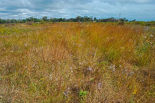
Northwest Indiana, nicknamed The Region after the Calumet Region, comprises Lake, Porter, LaPorte, and Newton counties in Indiana. This region neighbors Lake Michigan and is part of the Chicago metropolitan area. According to the 2020 Census, Northwest Indiana has a population of 831,080 and is the state's second largest urban area after the Indianapolis Metropolitan Area. It is also the home of the Indiana Dunes, parts of which have been preserved through conservation efforts. The town of Ogden Dunes houses the Hour Glass, a museum showcasing the ecological and conservation efforts of O. D. Frank.

Lake Chicago was a prehistoric proglacial lake that is the ancestor of what is now known as Lake Michigan, one of North America's five Great Lakes. Formed about 13,000 years ago and fed by retreating glaciers, it drained south through the Chicago Outlet River.
Powderhorn Lake, within Illinois but close to the state line, is a 48 acres (19 ha) lake that is part of the sand wetlands of the Indiana Dunes, most of which are located in the nearby state of Indiana. It is the centerpiece of the 192 acres (78 ha) Powderhorn Lake Forest Preserve, part of the Forest Preserve District of Cook County in Cook County, Illinois.

Adeline Jay Geo-Karis Illinois Beach State Park, part of the Illinois state park system, is located along Lake Michigan in northern Lake County in northeast Illinois. Together with lands to the north, including Chiwaukee Prairie, it forms the Chiwaukee Prairie Illinois Beach Lake Plain, an internationally recognized wet-land of importance under the Ramsar Convention. The park is broken into two units that encompass an area of 4,160 acres (1,683 ha) and contains over six miles of Lake Michigan shoreline. In 2010, it was renamed for former state senator Adeline Geo-Karis.

Ports of Indiana-Burns Harbor is an active maritime port owned by the State of Indiana. The state legislature created the Indiana Port Commission in 1961 to research and act upon opening maritime ports on Indiana's Lake Michigan shoreline as well as the Ohio River.

Cowles Bog is a 4,000-year-old wetland complex in Indiana Dunes National Park, near Chesterton, Indiana. It is named for Henry Chandler Cowles who did his pioneering work in ecology and ecological succession here. His work brought international attention to the area which led to efforts to preserve the Indiana Dunes. It was designated a National Natural Landmark in 1965. It contains bog, fen, marsh, wet meadow, swamp, and pond habitats.

The geography of Indiana comprises the physical features of the land and relative location of U.S. State of Indiana. Indiana is in the north-central United States and borders on Lake Michigan. Surrounding states are Michigan to the north and northeast, Illinois to the west, Kentucky to the south, and Ohio to the east. The entire southern boundary is the Ohio River.

The Kankakee Outwash Plain is a flat plain interspersed with sand dunes in the Kankakee River valley in northwestern Indiana and northeastern Illinois of the United States. It is just south of the Valparaiso Moraine and was formed during the Wisconsin Glaciation. As the glacier stopped at the Valparaiso Moraine, its meltwater was carried away to the outwash plain. On the south side of the moraine, where the elevation drops, the meltwaters eroded away valleys, carrying sand and mud with them. As the muddy meltwater reached the valley where the slope lessened, the water slowed, depositing the sand on the outwash plain. This created a smooth, flat, and sandy plain. Before its draining, the Kankakee Marsh, located on the outwash plain, was one of the largest freshwater marshes in the United States.

Miller Beach is a neighborhood of Gary, Indiana on the southernmost shore of Lake Michigan. First settled in 1851, Miller Beach was originally an independent town. However, the "Town of Miller" was eventually annexed by the then flourishing city of Gary in 1918. Located in the northeastern corner of Lake County, Indiana, the former town is now known as "The Miller Beach Community." Miller Beach borders Lake Michigan to the north, Porter County to the east, and is largely surrounded by protected lands, including Indiana Dunes National Park. Miller Beach is also the closest beach/resort community to Chicago, and has been a popular vacation spot since the early 20th century. As of the 2000 US census, it had a population of 9,900.

The Calumet Shoreline is an ancient shoreline of Lake Michigan located in the Lake Michigan Basin. It can be clearly seen as a sand ridge along Ridge Road south of Chicago. Closer to the lake from the Calumet Shoreline, there are the Tolleston shorelines and farther from the lake are the Glenwood Shoreline, the Tinley Moraine, and the Valparaiso Moraine. The shoreline is named after the Calumet Region of Northern Indiana.
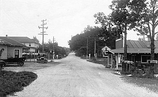
Tremont, Indiana, is a ghost town formerly located in what is now the Indiana Dunes State Park and Indiana Dunes National Park in Westchester Township in northern Porter County, Indiana. It was first established in 1833. It was located at the intersection of U.S. Highway 12 and County Road 100 East, near Indiana 49. The community is named for three massive sand dunes that are now contained within the State park. They are Mount Tom, Mount Holden 170 feet (52 m), and Mount Green 160 feet (49 m).

The Indiana Dunes comprise ten different habitats. Each provides for a unique combination of plants and animals. The range of the Indiana Dunes varies depending your source. The Indiana Lake Michigan Coastal Program uses the river drainage systems along the shoreline. This expands the area from the areas of lakeshore southward to the edges of the Valparaiso Moraine. This entire region has been dune landscapes since over 114,000 years before present (YBP). Traditionally, the Indiana Dunes area thought of as a narrow area along the shores of Lake Michigan, including the areas of Marquette Park in Gary, Indiana (1920), Indiana Dunes State Park (1926) and Indiana Dunes National Park,. The identified ten habitats can be found in these parks, where they have been preserved, but are also visible throughout the three counties of Northwest Indiana.

Brunswick is a neighborhood in northwestern Gary, Indiana, just south of Gary Chicago Airport. It borders Hammond and East Chicago to the west, and the Gary neighborhoods of Ambridge Mann to the east and Westside to the south. The borders are defined by the Indiana Toll Road on the north, Chase Street on the east, the Norfolk Southern railway on the south and Cline Avenue on the west. As of 2000, Brunswick had a population of 4,442 people, which was 84.6% African-American and 7.7% white. Like many Gary neighborhoods, Brunswick was a segregated white community until the early 1970s, when a massive white flight occurred.
Chiwaukee Prairie is a 485-acre (1.96 km2) prairie in Pleasant Prairie, Wisconsin managed by the Wisconsin Department of Natural Resources. It is located on Lake Michigan at the Illinois state line and includes grassy wetlands, wooded areas, and the Kenosha Sand Dunes at its northern tip. It is home to an abundance of wildlife. It was designated a Wisconsin State Natural Area in 1967 and a National Natural Landmark in 1973.
The Shirley Heinze Land Trust, originally known as the Shirley Heinze Environmental Fund, is a 501(c)(3) nonprofit land trust dedicated to the preservation of natural areas in Northwest Indiana. The Heinze Trust manages more than 2,800 acres of protected land in Lake, Porter, LaPorte, St. Joseph, Starke, and Marshall Counties in Indiana. Its preserves include a wide range of dune, wetland, prairie, and forest ecosystems.

The Grand Calumet River is a 13.0-mile-long (20.9 km) river that flows primarily into Lake Michigan. Originating in Miller Beach in Gary, it flows through the cities of Gary, East Chicago and Hammond, as well as Calumet City and Burnham on the Illinois side. The majority of the river's flow drains into Lake Michigan via the Indiana Harbor and Ship Canal, sending about 1,500 cubic feet (42 m3) per second of water into the lake. A smaller part of the flow, at the river's western end, enters the Calumet River, and through the Illinois ultimately drains into the Mississippi River.
Hessville is a neighborhood of Hammond, Indiana. Located in the southeast corner of Hammond, it adjoins the Hammond neighborhood of Woodmar to the west, the East Chicago neighborhood of Calumet to the north, the Gary neighborhoods of Westside and Black Oak to the east, and the town of Highland to the south. The neighborhood's boundaries correspond to Hammond's Planning District VI.
