Related Research Articles

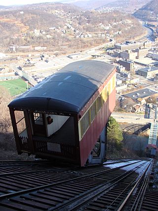
The Horseshoe Curve is a three-track railroad curve on Norfolk Southern Railway's Pittsburgh Line in Blair County, Pennsylvania. The curve is roughly 2,375 feet (700 m) long and 1,300 feet (400 m) in diameter. Completed in 1854 by the Pennsylvania Railroad as a way to reduce the westbound grade to the summit of the Allegheny Mountains, it replaced the time-consuming Allegheny Portage Railroad, which was the only other route across the mountains for large vehicles. The curve was later owned and used by three Pennsylvania Railroad successors: Penn Central, Conrail, and Norfolk Southern.

The Allegheny Portage Railroad was the first railroad constructed through the Allegheny Mountains in central Pennsylvania. It operated from 1834 to 1854 as the first transportation infrastructure through the gaps of the Allegheny that connected the midwest to the eastern seaboard across the barrier range of the Allegheny Front. Approximately 36 miles (58 km) long overall, both ends connected to the Pennsylvania Canal, and the system was primarily used as a portage railway, hauling river boats and barges over the divide between the Ohio and the Susquehanna Rivers. Today, the remains of the railroad are preserved within the Allegheny Portage Railroad National Historic Site operated by the National Park Service.
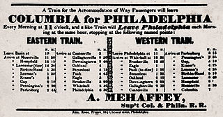
Philadelphia and Columbia Railroad (P&CR) (1834) was one of the earliest commercial railroads in the United States, running 82 miles (132 km) from Philadelphia to Columbia, Pennsylvania, it was built by the Pennsylvania Canal Commission in lieu of a canal from Columbia to Philadelphia; in 1857 it became part of the Pennsylvania Railroad. It is currently owned and operated by Amtrak as its electrified Keystone Corridor. The Philadelphia and Columbia Railroad's western terminus was located near the former ferry site known as Wright's Ferry, in the town once of that name, but now Columbia in Lancaster County. There the P&CR met with the Pennsylvania Canal—navigations and improvements on the Susquehanna River east bank approximately 30 miles (48.3 km) south of Harrisburg, Pennsylvania. Most of its right-of-way was obtained by the actions of the Pennsylvania Canal Commission which operated the railroad under the various enabling acts of the Pennsylvania legislature known as the Main Line of Public Works in support of a far sighted plan to link the whole state by canals. With an engineering study reporting back a finding that obtaining sufficient waters to flood the intended 80+ mile canal from Philadelphia to Columbia, the Canal Commission and legislature authorized the railway on the right of way intended for the canal.

The Duquesne Incline is a funicular located near Pittsburgh's South Side neighborhood, scaling Mt. Washington in the United States. Designed by Hungarian-American engineer Samuel Diescher, the incline was completed in 1877.

The Monongahela Incline is a funicular located near the Smithfield Street Bridge in Pittsburgh, Pennsylvania. Designed and built by Prussian-born engineer John Endres in 1870, it is the oldest continuously operating funicular in the United States.

The Knoxville Incline was a broad gauge inclined railway that ran between Pittsburgh's South Side and Allentown neighborhoods. The incline was built in 1890 and had a track gauge of 9 feet (2,700 mm).
The Keeling Coal Company (1861–1878) was a 19th-century coal mining company in Allegheny County, Pennsylvania. Its mines were located in the Pittsburgh Coalfield of western Pennsylvania.

The Castle Shannon Incline was a funicular railroad in Pittsburgh, Pennsylvania. It was originally part of the Pittsburgh and Castle Shannon Railroad route to the suburb of Castle Shannon. It replaced an earlier incline dating to 1825 that brought coal down from a mine in Mount Washington.
The Clifton Incline was a funicular that operated from 1889 to 1905 in what is now the Perry Hilltop neighborhood of Pittsburgh, Pennsylvania. It extended from its base at Sarah Street at the intersection with Myrtle Street to its top landing at Clifton Park near the end of Clifton Street.
The Fort Pitt Incline was a 10 ft gauge funicular railroad in the Bluff neighborhood of Pittsburgh. Opened in 1882, the incline ran from 2nd Avenue to Bluff Street, a distance of 350 feet (107 m), and a vertical distance of 135 feet (41 m). The designer was Samuel Diescher.
Samuel Diescher was a prominent Hungarian-American civil and mechanical engineer who had his career in the United States. After being educated at universities in Karlsruhe and Zurich in Europe, he immigrated to the United States in 1866 and settled in Cincinnati, Ohio. There he supervised construction of his first inclined plane. He later moved to Pittsburgh, Pennsylvania, where he worked with John Endres on the Monongahela Incline (1870), the first passenger incline in the city.

The Mount Oliver Incline was a funicular on the South Side of Pittsburgh, Pennsylvania. It was designed in 1871 by the Prussian-born engineer John Endres and his American daughter Caroline Endres, one of the first women engineers in the United States.

The Nunnery Hill Incline was a funicular located in Allegheny City, Pennsylvania, in what is now the Fineview neighborhood of Pittsburgh.

Castle Shannon Incline Number 2 was an inclined cable railway in Pittsburgh, Pennsylvania. It was originally designed by Samuel Diescher, and opened in 1892 as part of the Pittsburgh and Castle Shannon Railroad as a means of transporting passenger traffic over Mt. Washington in concert with the Castle Shannon Incline. From the top station at Bailey Street, adjacent to the Castle Shannon Incline top station, No. 2 ran down hill west of Haberman Avenue, ending at Warrington Avenue.
The St. Clair Incline, also known as the South Twenty-second Street Incline, was built in 1886–1888 and operated by St. Clair Incline Plane Company. It was a double track incline on the South Side Slopes of Pittsburgh from Josephine St. to Salisbury St. The lower station was near the intersection of S. 22nd Street and Josephine. The upper station was on Salisbury Street across from the former Fort Laughlin site eventually occupied by Arlington Playground. The incline was 2,060 ft (628 m) long, with a vertical rise of 361 ft (110 m). It was designed by engineer J. H. McRoberts. As it carried both freight and passengers over steep tracks laid on the ground, it could be considered to be a cable railway. Its path was not of constant slope but became progressively steeper toward the top, tracing a parabolic arc. It is uncertain exactly when the incline closed permanently, but it was reported as shut down in a 1932 Associated Press article about the "passing" of Pittsburgh's inclines. The structure was dismantled in 1934.
Pittsburgh, Knoxville & St. Clair Electric Railroad was one of the earliest electric street railways. A licensee of the Daft System, the line struggled with difficult terrain, required expensive bridges, and failed financially within just 3 years of opening.

The Troy Hill Incline, also known as the Mount Troy Incline, was a funicular railway located in old Allegheny, Pennsylvania, which is now the North Side of the city of Pittsburgh.

The Penn Incline, also known as the 17th Street Incline, was a funicular railroad that ran between the Strip and Hill districts in Pittsburgh, Pennsylvania. It operated from 1884 to 1953.
References
- 1 2 3 4 5 "A Passenger Incline Railroad". Railroad Gazette. 18 (53): 912. 31 December 1886. hdl:2027/mdp.39015013053692.
- 1 2 Rooney, Dan; Peterson, Carol (2013). Allegheny City: A History of Pittsburgh's North Side. University of Pittsburgh Press. pp. 103–104. ISBN 978-0-8229-4422-5.
- ↑ Bothwell, Margaret P. (Oct 1963). "Inclined Planes and People—Some Past and Present Ones". The Western Pennsylvania Historical Magazine. 46 (4): 339.
- ↑ "An Incline Burned". The Post. Pittsburgh. 31 May 1887. p. 2 – via Newspapers.com.

- ↑ Real estate plat-book of the city of Allegheny (Map). G. M. Hopkins & Co. 1890. Vol. 1, Plate 6.