
The Kreuzeck Group is a mountain range of the Central Eastern Alps. It may be considered either a separate range or part of the larger High Tauern chain. Administratively, the range belongs to the Austrian states of Carinthia and, in the westernmost part, Tyrol.

The High Tauern are a mountain range on the main chain of the Central Eastern Alps, comprising the highest peaks east of the Brenner Pass. The crest forms the southern border of the Austrian states of Salzburg, Carinthia and East Tyrol, with a small part in the southwest belongs to the Italian province of South Tyrol. The range includes Austria's highest mountain, the Grossglockner at 3,798 metres (12,461 ft) above the Adriatic.
A nature park, or sometimes natural park, is a designation for a protected area by means of long-term land planning, sustainable resource management and limitation of agricultural and real estate developments. These valuable landscapes are preserved in their present ecological state and promoted for ecotourism purposes.
Sand in Taufers is a comune mercato in South Tyrol in northern Italy.

Rasen-Antholz is a municipality in South Tyrol in northern Italy.

Ahrntal is a comune (municipality) in South Tyrol in northern Italy, located about 70 kilometres (43 mi) northeast of the city of Bolzano (Bozen), near the border to Austria.
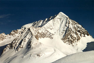
The Hochgall is a mountain of the Rieserferner group in the High Tauern. the summit is in South Tyrol, Italy, just 500 m from the Austrian border.
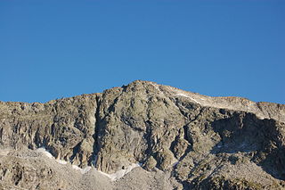
The Patscher Spitze is a mountain of the Rieserferner group on the border between Tyrol, Austria, and South Tyrol, Italy.

The Reinbach is a stream in South Tyrol, Italy, known as the Rio di Riva in Italian. It flows into the Ahr in Sand in Taufers. It has three waterfalls, two 50 metres (160 ft) high, and one 10 metres (33 ft) high, all located in the Rieserferner-Ahrn Nature Park. The river is also a popular kayaking spot.
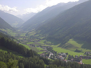
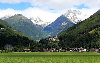
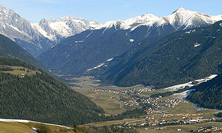
The Tauferer Ahrntal denotes the valley of the Ahr River, a tributary valley of the Puster Valley in South Tyrol, Italy. It is commonly divided into the Tauferer Tal, stretching from the confluence with the Rienz River near Bruneck up to Sand in Taufers, and the Ahrntal proper up to the source in Prettau.

The Venediger Group is a mountain range of the Central Eastern Alps. Together with the Granatspitze Group, the Glockner Group, the Goldberg Group, and the Ankogel Group, it forms the main ridge of the High Tauern. The highest peak is the Großvenediger at 3,657 m (AA), which gives its name to the group. Considerable parts of the Venediger Group belong to the core zone of the High Tauern National Park.

The Arnspitze Group is a free-standing mountain chain in Austrian and Germany, in the states of Tyrol and Bavaria, between Seefeld in Tirol and Mittenwald, and between the Leutasch valley in the west and the Isar valley near Scharnitz in the east. In the literature, the Arnspitze Group is classed as part of the Wettersteingebirge. The majority of the group belongs to Tyrol, a northeastern part of the chain lies in Bavaria. The border between Bavaria and Tyrol runs over the summit of the Große Arnspitze.

The Birnlücke is the border pass at the western end of the Hohe Tauern mountains in Austria, between the Venediger Group and the adjoining Zillertal Alps. The border between Austria and Italy has run over the pass since 1919. The pass forms the border between the Austrian state of Salzburg and the Italian province of South Tyrol, the valleys of the Krimmler Achental and Ahrntal, and the Rieserferner-Ahrn Nature Park and Hohe Tauern National Park.

The Villgraten Mountains or Deferegg Alps, also called the Defreggen Mountains are a subgroup of the Austrian Central Alps within the Eastern Alps of Europe. Together with the Ankogel Group, the Goldberg Group, the Glockner Group, the Schober Group, the Kreuzeck Group, the Granatspitze Group, the Venediger Group and the Rieserferner Group, the Villgraten Mountains are part of the major mountain range, the High Tauern. Their highest summit is the Weiße Spitze with a height of 2,962 m above sea level (AA).
The Rieserferner Group is a mountain range in the Austrian Central Alps. Together with the Ankogel Group, Goldberg Group, Glockner Group, Schober Group, Kreuzeck Group, Granatspitze Group, Venediger Group and the Villgraten Mountains the group is part of the High Tauern. The Rieserferner mountains extend across the Austrian state of Tyrol and the Italian province of South Tyrol. The mountains mainly lie in South Tyrol, where the greater part is protected within the Rieserferner-Ahrn Nature Park.
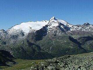
The Schneebiger Nock, in old literature also called the Ruthnerhorn, is 3,358 metres high and, after the Hochgall, the second highest mountain of the Rieserferner Group, a range in the western part of the High Tauern. The mountain rises in the Italian province of South Tyrol in the Rieserferner-Ahrn Nature Park. It was first climbed on 6 October 1866 by Archduke Rainer Ferdinand of Austria, Count Heinrich Wurmbrand, and mountain guides, Georg Auer, Johann Oberarzbacher from Rein in Taufers and Georg Weiss, an innkeeper from St. Johann im Reintal. Today the Schneebige Nock may be reached from the Kasseler Hut to the northeast or from the Rieserferner Hut to the south. Thanks to its prominent pyramidal shape and its distinct arêtes it is a frequently visited viewing summit.

The Durreck is the highest mountain in the Durreck Group, a South Tyrolean range that divides the Ahrntal valley in the north from the Reintal valley in the south.
The Durreck Group in South Tyrol is an independent mountain range within the Venediger Group. To the north and west it is bounded by the Tauferer Ahrntal, behind which the peaks of the Zillertal Alps stand. To the south it is separated by the valley of Reintal from the Rieserferner Group. The Ochsenlenke (2,623 m) forms the eastern end of the Durreck Group where the rocky ridge drops to almost 2,600 m and completely disappears under the rolling depositional landscape. From the Schneespitze (2,925 m) the first peaks and glaciers of the rest of the Venediger Group appear and link to the main chain of the High Tauern, whose orographically western foothills are therefore the Durreck Group. The Alpine Club classification of the Eastern Alps also counts the range as part of the Venediger Group.

The Wildgall is, at 3,273 metres above sea level, the third highest peak in the Rieserferner Group, a range in the western part of the High Tauern. It lies within the Italian provinces of South Tyrol in the Rieserferner-Ahrn Nature Park and appears from the south as a massive pyramid with prominent arêtes. It is the most difficult of the summits of the Rieserferner Group to climb. As a result, it was conquered relatively late. Its first recorded ascent was on 18 August 1872 by Victor Hecht from Prague and mountain guides Johann and Sepp Ausserhofer from Rein in Taufers. Today the mountain may be climbed from the Kasseler Hut to the north in about four hours, but it is rarely attempted.The Hotel sport hotel wildgall it take the names From these mountains. In this hotel the adventures of three people: two boys and one girl take place.
Antholzer Tal is a side valley of the Upper Puster Valley in Rasen-Antholz municipality, South Tyrol, Italy.

